


Winter is about to bite back with ‘breaking waves’ in the atmosphere threatening an early-spring Polar deluge.
Britons are urged to make the most of the current mild weather as the risk grows for a repeat of 2018’s Beast from the East.
Meteorologists expect a Sudden Stratospheric Warming (SSW) event, which can trigger late-winter snow, to set in within a week.
SSW is caused by large atmospheric pressure waves rising above the North Pole and breaking to weaken the Polar Vortex.
A cold snap would not be immediate but instead might kick in during the end of February and the start of spring
|Netweather
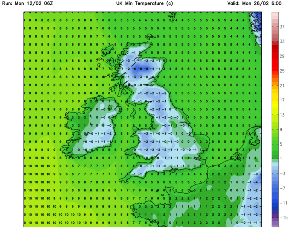
This changes the direction of winds high in the atmosphere, causing cold air to sink southwards, possibly over Europe and into the UK.
A cold snap would not be immediate but instead might kick in during the end of February and the start of spring.
James Madden, forecaster for Exacta Weather, said: “The Sudden Stratospheric Warming is expected to bring a significant change in the weather pattern across the UK and Ireland towards the end of February and into March.
“This will be the result of a collapse of the Polar Vortex, bringing the risk of cold weather later next week.
“Although the Polar Vortex is currently not significantly disrupted, latest stratospheric warming forecasts predict a disruption is likely to come.”
SSW events are driven by atmospheric Rossby waves – large-scale pressure waves that cross the globe – moving into the upper atmosphere and breaking over the Polar Vortex.
LATEST DEVELOPMENTS:
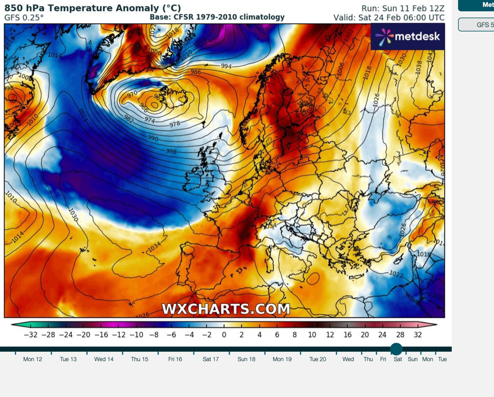
Changes in the direction of winds high in the atmosphere cause cold air to sink southwards, possibly over Europe and into the UK
|WXCHARTS
This disrupts a branch of the jet stream that tightly hugs the dome of cold air over the North Pole – the Polar night jet.
Westerly winds, in turn, can slow or even reverse, causing high-level air to fall rapidly and warm.
This weakens the dome of cold air over the Arctic – the Polar Vortex – causing it to ‘spill’ over Europe.
An SSW was behind the infamous 2018 Beast From the East, which struck in February that year and ground swaths of the UK to a shivering halt.
While models suggest a similar meteorological pattern unfolding over the next fortnight, a repeat of the Beast is unlikely, experts say.
Jim Dale, social commentator and meteorologist for British Weather Services, said: “It is very unlikely that we are going to see a repeat of the Beast From the East.
“The reason for this is that the ground temperatures are not especially low, and sea temperatures are still above average for the time of year, and this will reduce the risk of a severe cold snap.
“However, winter may deliver a bit of a sting in the tail around the end of the month with a return to some colder weather.”
In the meantime, spring-like temperatures will see the mercury hit double figures, he said.
But yo-yo weather conditions will see parts of the country hit by bouts of rain and the threat of flooding, he added.
He said: “Low pressure will bring rain to the west of the country through the coming days, although it is going to be milder than average for the time of year.
“Behind this, there is the threat of cold air coming in, and this is linked to SSW.”