


A TROPICAL supercharge from an Atlantic hurricane is about to drive a 30C mini heatwave as the start of autumn heralds the ‘hottest spell since June’.
Sizzling warmth will sweep in from the Continent this weekend, driven by the remains of Hurricane Franklin as they head towards northern Europe.
A record number of storms – including the devastating Idalia which mauled swathes of Florida this week – have in the past week been reported in the Atlantic basin.
All have the potential to shake UK weather patterns through the coming weeks, delivering stormy outbursts or blasts of unseasonable warmth.
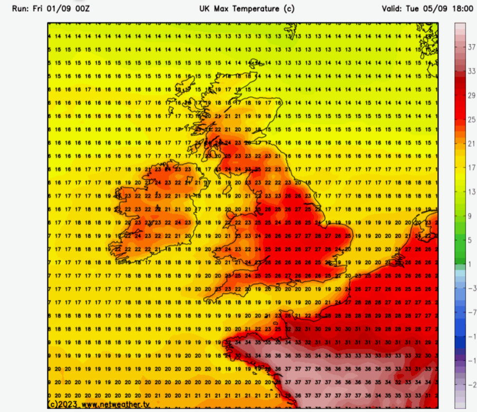
Temperatures to hit the high 20s next week with some forecasters predicting 30C
|Netweather.tv
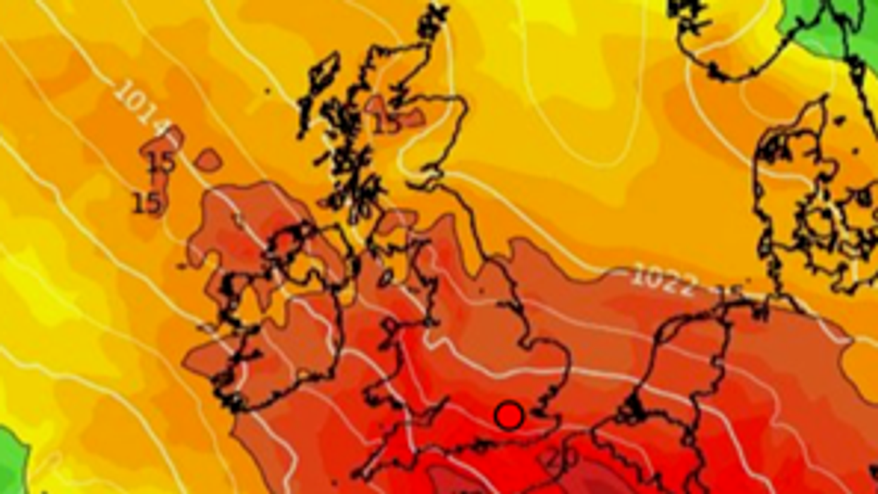
Temperatures next week are forecast to nudge 30C as tropical air from Franklin sweeps across the Atlantic, jolting the jet stream and driving high pressure and warm sunshine.
Jim Dale, meteorologist for British Weather Services, said: “The best of the weather will start to build through the weekend and the start of next week with temperatures in parts hitting the high-20Cs or even a possible 30C.
“High pressure is expected to build as the remains of Hurricane Franklin move to the north of the UK, shifting the jet stream and bringing warm air in from the Continent.
“I expect the very warm weather to last through the rest of next week with most of the country in for some very pleasant conditions.
“The best of the weather and the highest temperatures will be in the south of Britain, with Northern Ireland and southwestern regions likely to stay cooler with the chance of unsettled conditions towards the middle of the week.”
Huge amounts of energy and moist, tropical air whipped up by Hurricane Franklin will be the main ingredient in the latest weather twist.
Experts are also monitoring another three storms, Idalia, Gert, and Jose, and a tropical depression off the coast of Africa, during one of the busiest Atlantic hurricane seasons on record.
The unusually active Atlantic basin is throwing doubt over the weather closer to home, although forecasters predict more hot spells in the pipeline.
Mr Dale, author of ‘Weather Or Not?’, said: “September has the potential to be the new summer month, and with such a high level of activity in the Atlantic this year, there is every chance that we will see further spells of hot weather before the end of the month.
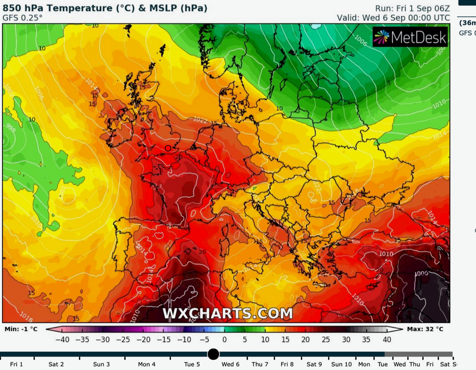
Warm air sweeps up from the Continent
|WX Charts
However, the longer-range outlook remains uncertain with the chance of further rain and unsettled weather.
Exacta Weather forecaster James Madden said: “A much awaited and substantial area of high pressure is now set to dominate our weather pattern from the early part of next week.
“Temperatures are likely to reach the low 20Cs and there a good chance these will rise as this week progresses.
“We could very well see maximum temperatures in the high 20Cs and 30C can't be ruled out.”
“The other scenario is that some of these systems could take a slightly southerly track towards the UK and bring more of an unsettled picture.
“In the meantime, though, Britain is about to get what is likely to be the hottest spell of weather since June.”
Met Office weather models also favour the remains of Hurricane Franklin bringing higher pressure and warm weather next week.
Its remnants will arrive laden with tropical energy which will ‘buckle’ the jet stream helping to drive the change, according to Met Office meteorologist Aidan McGivern.
He said: “The big question marks into next week are the degree to which the settled weather and the high pressure in the south affects the UK, and the affect to which the changeable weather affects the UK.
“That question mark hinges on the behaviour of these hurricanes, Franklin and Idalia.
“Hurricane Franklin is going to push north over the next few days, and the Met Office computer run has Franklin pushing into the North Atlantic and that has consequences for our own weather.
“It is going to push some energy and some warmth into the jet stream which in turn buckles the jet stream and allowing high pressure to build across the UK.”

Met Office’s Aidan McGivern explains how Franklin could bring warmer weather
|Met Office
In the meantime, southern regions will get the best of the weather this weekend while Scotland and northern England stay cooler and wetter, he added.
He said: “For the start of the high pressure, a ridge of high pressure in a ridge of the jet stream will lead to fine and settled conditions for the vast majority.
“It will feel warm in the sunshine, but there is some cloud around, so it is not completely blue skies.
“It is going to feel a bit warmer on Sunday with temperatures reaching 24C or 25C in the south, but cooler under the rain in the north.”
Independent weather forecasters agree the picture for the next week is for a glorious return to summer.
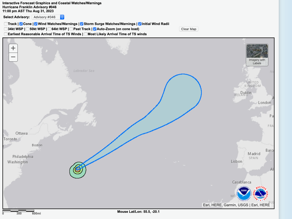
Path of Franklin makes a beeline for UK
|National Hurricane Center