


Storm Babet could be about to kick-start a fortnight of wind and rain hell with cyclonic assaults threatening to smash Britain into early November.
The UK is taking cover for the second named storm of this year’s season, poised to pounce within hours unleashing 70mph winds and torrential downpours.
Government forecasters have issued a splattering of warnings as the deep low-pressure system rips in from the south.
It could be the first of several to smash UK shores before winter as alarm bells are sounded for weeks of autumn storm misery and even heavy snow.
James Madden, forecaster for Exacta Weather, said: ““We could be looking at more extremely stormy periods of weather through the final third of October and into November.
“The more dominant theme will be for more unsettled weather this week and further ahead, which in essence will mean the UK is going to start feeling more typically autumnal.”
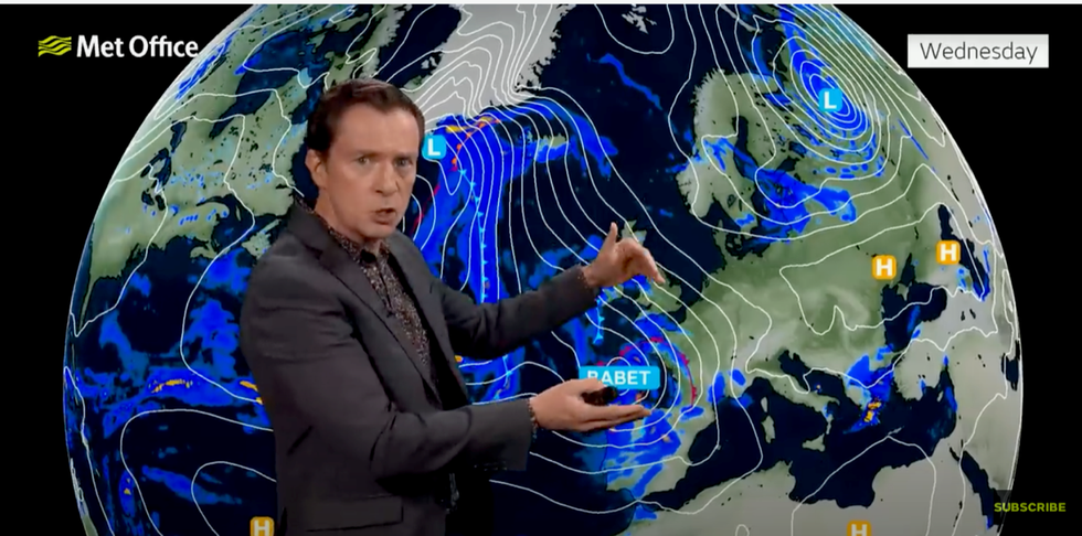
Met Office meteorologist Alex Deakin warns Babet is on the way
|Met Office
The storm could usher the first heavy snowfall of the year as it crashes into cold air wedged over Britain, he warned.
He added: “After temperatures have been warmer than average for the past couple of weeks, this pattern will change, and the heating will be coming on for the first time.
“We could see the first significant snow of the season across parts of the north, which is looking like good news for the ski resorts.”
The Met Office has a raft of alerts in place until the end of the week as Babet fires up to launch a three-day storm assault.
WATCH NOW: Met Office UK weather forecast
Wind and rain will whip up this afternoon with swathes of Scotland and eastern Britain in the firing line for the full force of its fury ahead of the weekend.
An amber warning for up to eight inches of rain is in force in Tayside and Fife, with a separate alert for rain in place across eastern Britain and another for wind in the Highlands.
Gales of 70mph threaten travel delays, damage to buildings and trees and huge coastal waves.
Heavy rain and floods could lead to power cuts and disruption to essential services such as gas, water and mobile phone signals, the Met Office warned.
Deputy chief meteorologist, Steven Keates said: “Storm Babet will bring impactful rain to many parts of the UK, but especially parts of eastern Scotland, Northern Ireland and northern England later this week.
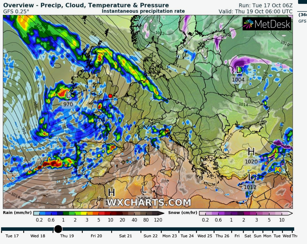
Spiral of rain to drench Britain
|WX Charts
“Heavy and persistent rain will fall onto already saturated ground bringing a risk of flooding.
“It is important to stay up to date with warnings from your local flood warning agency as well as the local authorities.
“As well as heavy rain, Storm Babet will bring some very strong winds and large waves near some eastern coasts too.”
Jim Dale, meteorologist for British Weather Services, added: “The weather is going to make a dramatic change during the middle of the week, with Storm Babet impacting the UK.
“This will bring wind and rain through Wednesday and Thursday.
“There will be a risk of flooding in Scotland, possibly Wales, and more widely across the UK, especially in the more prone areas.”
Storm Babet could bring the wettest day of the year so far, prompting bookmakers Ladbrokes to slash the odds on rain records falling.
Spokesman Alex Apati said: "Things are about to get a whole lot wetter with record-breaking rain ready to batter Brits."
Government forecasters have urged Britons to keep a close eye on weather reports with storm warnings expected to change through the coming days.
Babet will be slowed on its journey by a region of high pressure to the northeast, giving it time to dump its load across the UK.
Met Office meteorologist Alex Deakin said: “Storm Babet is on the way.
“As the storm system tracks northwards it will be picking up moisture, and it will also be turning quite windy, but it will be mostly the rainfall.
“It is being slowed by an area of high pressure over Scandinavia, and that could really stall the weather fronts, and they could drop several hours of heavy rain in some locations.
“The wind strengthens further as the storm tracks further north during Tuesday night and Wednesday.
“Keep up to date with the latest and check out the details of the weather warnings.”