


Britain is braced for a 10-day deluge as powerful jet-stream winds drag in a ‘tangle’ of rain-loaded weather systems.
Low-pressure, responsible for the autumn washout so far, will dominate the UK through the run up to November.
But, a south-westerly blast will bring a pulse of warmth to the nation after the weekend, pushing temperatures next week into the mid-teens.
However, the main theme for almost the next fortnight is going to be more rain, according to the Met Office.
Met Office meteorologist Alex Deakin said: “I can guarantee there will be more rain in the next 10 days.
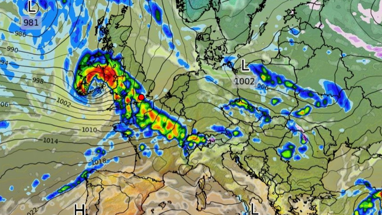
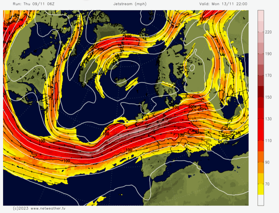
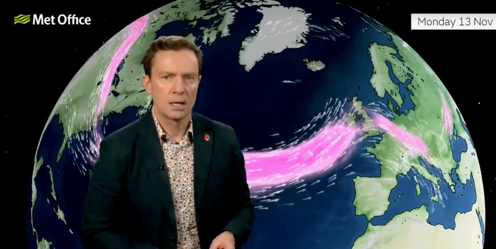
“The jet stream has been particularly active recently, and also particularly south-shifted, bringing low-pressure systems and wet weather across Spain and France as well as bringing them towards the UK.
UK weather warning: Jet Stream ploughs across UK
|Netweather
“There is another ribbon high in the atmosphere of active strong winds with the jet stream barrelling its way towards the UK for the new working week.”
Freakish pressure patterns will drive a mini-cold snap on Saturday as the UK is sandwiched between two lows and two highs–a so-called ‘col’.
Northern regions will see the worst of any frost as the UK enjoys a brief chilly calm in ‘weather no-man’s land’.
Mr Deakin said: “On Saturday there is a brief respite, we are in what’s known as a ‘col’, you are between two areas of low pressure and two areas of high pressure, it is a bit of a weather no-man’s land.
“There will be a bit of frost around this weekend, but on Saturday many places will have a dry and a bright day.
“There will be a more widespread frost for Sunday morning.”
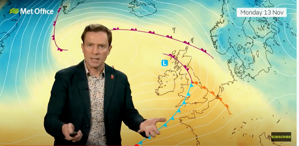
Met Office’s Alex Deakin warns of a ’tangle of fronts’
|Met Office
Storms threaten to deliver a greater threat through the second half of the month, according to some forecasters.
While rain will be the biggest problem through next week, strengthening low-pressure could see Storm Debi–the next named storm after Ciaran–after mid-month.
Jim Dale, social commentator and meteorologist for British Weather Services, said: “Rain is going to be the main story this weekend and into the start of next week.
“There is the potential for another storm to hit the UK around mid-month, and this is something we are now keeping a watch on.
UK weather: Jet stream sweeps Britain
|Met Office
“While this is not a certainty, we are in a regime of autumn storms which are coming in off the Atlantic, and this, for the moment, is showing no signs of change.”
Rain next week may be joined by the return of strong winds as the jet stream fires up over the UK.
If the jet takes on a wavy ‘meridional’ shape, the weather will be calmer, but if it straightens as it strengthens, the nation will be on alert for wind.
Mr Deakin said: “With the jet stream coming in like this, that means low pressure, and that is going to dominate our weather for the next several days.
“How strong the winds get will be determined by the exact shape of the jet stream and how it wiggles.”