
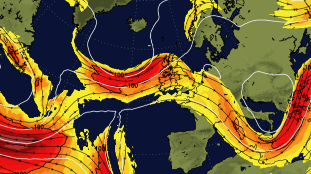


A ‘zonal’ jet stream will fuel another week of rain while energy ploughed into the atmosphere by mild weather drives thunderstorms.
Unsettled conditions are forecast largely through the next 10 days, although southerly gusts will start to push the mercury upwards.
The wet and windy picture is thanks to the jet stream picking up strength and taking on a straighter path across the Atlantic.
Colder, drier conditions over the past few days have been the result of a ‘meridional’ jet, a wavier form that allows high pressure to build in the loops.
Unusually mild weather through February–the mildest on record in England and Wales according to the Met Office–and warm sea temperatures will add a threat of thunderstorms, experts warn.
Jim Dale, meteorologist for British Weather Services and social commentator, said: “For the next ten days it is really going to be stop-start in terms of rain, and this is because the jet is in a zonal position, bringing low pressure and associated fronts in from the Atlantic.
“There will be a risk of thunderstorms because the overall milder weather through February and generally mild conditions through this month will put more energy into the atmosphere.
“With the higher sea temperatures around the UK, the ingredients are present for changeable and stormy conditions.”
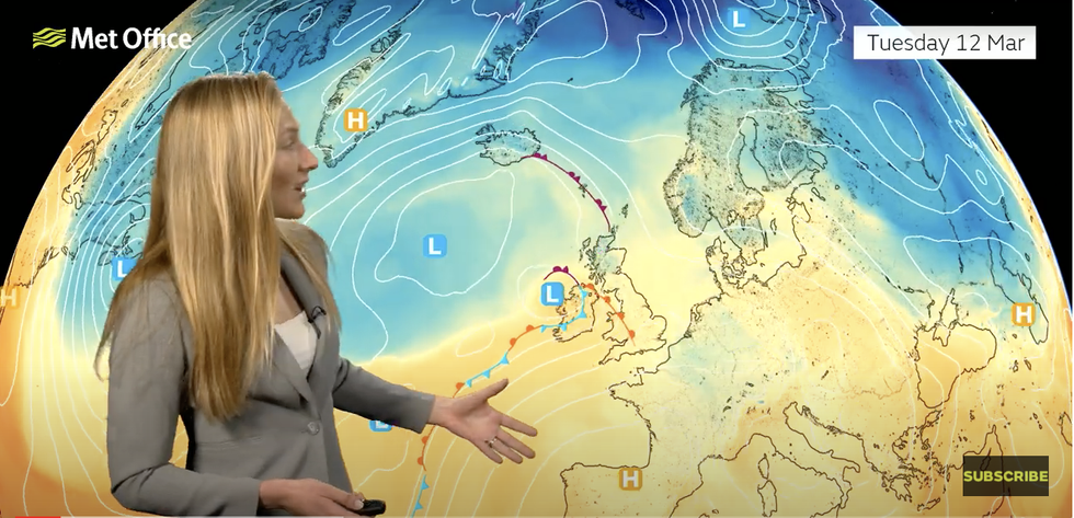
Annie Shuttleworth forecasts milder conditions
|Met Office
Meteorologists are forecasting a change in the weather from the middle of the week as the jet takes a more direct path across the UK.
Regions of low pressure to the west of the country will steer winds in from the south, pushing temperatures in parts into double figures.
Thermometers are expected to nudge 15C across southern England by the weekend, although Scotland and the north will hover just below 10C.
Met Office meteorologist Annie Shuttleworth said: “There will be further rain for many areas through the rest of the week, but there is also going to be some drier and brighter weather and it is going to start to feel quite a bit milder as the week goes on.
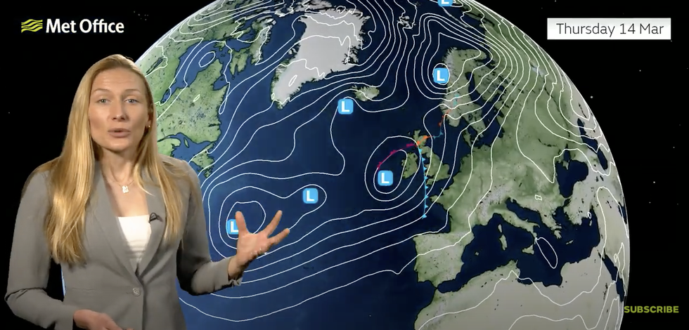
UK weather: With low pressure to the west of the UK
|Met Office
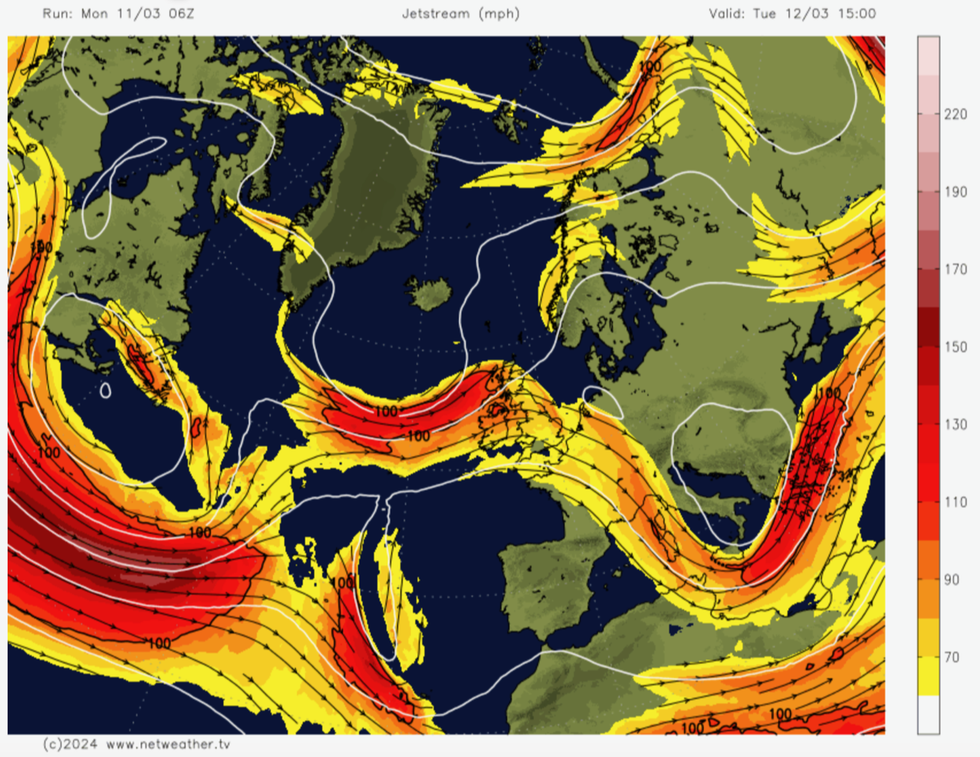
The jet stream is causing unsettled weather
|Netweather
“That’s as this milder air from the south arrives through the course of Tuesday behind a weather front.
“A string of weather fronts continue to bring outbreaks of rain through the rest of the week.
“We are expecting some pretty heavy rain through the course of Wednesday night, to many northern areas of England and then into southern Scotland by Thursday.”
Low pressure will be the driver for much of the unsettled weather through the week, pulled in from the Atlantic on the jet stream.
The systems are trailed by cold and warm weather fronts which, when they meet airmasses over the UK, trigger rainfall.
Temperatures, despite a stiff breeze, could hit 16C in the sunshine by the end of Thursday, Ms Shuttlewort said.
She added: “It’s a bit of a mixed bag through much of the week, and then it’s Thursday into Friday when an area of low pressure that has been bringing a string of fronts finally pushes through the UK, and that will bring a more widely settled and showery day on Friday.”