
US snow weather: Arctic winds plunge America into record freeze with 'enhanced' snow to last MONTHS

Temperatures plummet across eastern states
THE WEATHER CHANNEL

A freezing blast sweeping the United States is about to bring a ‘record’ cold snap with parts of the country facing snow until spring.
Temperatures will nosedive as Arctic winds plough east into the mid-west, the mid-Atlantic and New England states.
Great-Lake regions face ‘enhanced’ snowfall as moist air passes over waters still warm from summer into colder surroundings to unleash a winter deluge.
Eastern states could be buried under snow into spring thanks to global climate events extending winter conditions through the start of 2024.
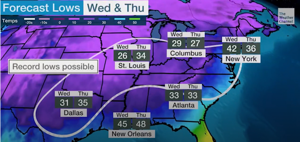
Record Low temperatures possible
THE WEATHER CHANNEL
A strong El Nino, the first for four years, will shift the spring snow risk from north-western states, which bore the brunt last winter, to the eastern United States.
Weather Channel meteorologist Jonathan Erdman said: “A stronger El Niño is likely to be in place through spring, and that could mean big changes in snow, rain and temperatures compared to last winter in the US.
“This year’s El Nino first developed in June and is the first in more than four years.
“Since the end of August, its warm temperature anomalies have pushed above the threshold of a strong El Niño, at least 1.5 degrees Celsius, or 2.7 degrees Fahrenheit, warmer than average.
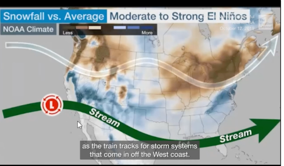
Jet stream pushed south by El Nino to bring snow to the east
THE WEATHER CHANNEL
“The two main changes in snowfall we may see this season due in part to this stronger El Niño are less snow in the Pacific Northwest, northern Rockies and upper Midwest, and more snow in parts of the mid-Atlantic states.”
El Nino will drive the jet stream further south increasing the risk of southerly snow, according to Weather Channel meteorologist Ari Sarsalari.
The jet will behave as ‘train tracks’ steering snow-bearing low-pressure storms in from the west coast, he said.
This will help bring an usually severe winter deluge to the central Rockies, the Seirra, and into mid-Atlantic regions, he warned.
He said: “When the jet stream is farther towards the south, it gives us a better chance of ending up with an area of low pressure off the southeast coast.
“A lot of cold air filters into the backside of the system, and you end up with more snow in that area.”
The warnings come as swathes of the east coast this week face freezing winds, frosts, ice and record low temperatures.
The region is braced for the ‘first taste of winter’ with the mercury to plummet in the run up to the weekend.
Lows of -4C are forecast for Bismarck, North Dakota; 5F for Detroit, 2C for New York, and 1.6C for Dallas.
Weather Channel meteorologist Domenica Davis said: “The first taste of winter is in the forecast and temperatures are going to get really cold over the next couple f days from the southern plains all the way to the northeast.”
Jim Dale, US weather correspondent and senior meteorologist for British Weather Services added: “Through the start of November, all the cold air will have moved form the west into the east.
“Snow will be a risk along a cold front which stretches all the way down to Texas, and across to Maine, New York, and New England.
“There is the potential in some of these states to see some record low temperatures for the time of year.”


