


Britain will be plunged back into winter this weekend with a -10C Nordic snow ‘shock’ threatening to keep the nation on ice until April.
An exceptional period of cold weather will drive a barrage of ‘large-scale snow events’ leaving parts of the UK under a 10-inch winter blanket.
Sub-zero winds will roar in on Sunday as the Polar Vortex–a mass of air circling the North Pole–plunges across Europe driven by a Sudden Stratospheric Warming (SSW) event.
The phenomenon, which drove the crippling 2018 Beast from the East almost five years ago to the day, was confirmed last month to have set in over the Arctic.
Air currents high above the North Pole will descend and disrupt the jet stream triggering unseasonably cold weather across the Continent through this month and possibly beyond.
Exacta Weather forecaster James Madden said: “Snow will start to hit broadly across the north and east of the UK by the end of the weekend before spreading across the country ahead of mid-month.
“There is then the potential for further large-scale snow events to hit the UK through the rest of the month which will prove a shock to the system for many, largely because it will be unexpected, but also because this time last year we were talking about an early heatwave.
“We should start preparing now for an exceptional period of prolonged cold with several widespread snow events which could reach lower regions of the country.”
Temperatures show little sign of recovering through the first month of spring as Polar air smothers the country, he warned.
He added: “March is likely to come in at much colder than average overall, and there is still the ever-growing risk of some potential cold weather records to be broken.”
The month-long freeze will strike in two stages beginning on Sunday as a surge of Arctic winds ploughs across Scandinavia and the Nordic regions into Britain.
Around mid-month a milder wind belt from the south will arrive laden with moisture and crash against cold air unleashing torrents of snow.
Long-range outlooks predict a lengthy stay in the chiller despite this week marking the start of the meteorological spring.
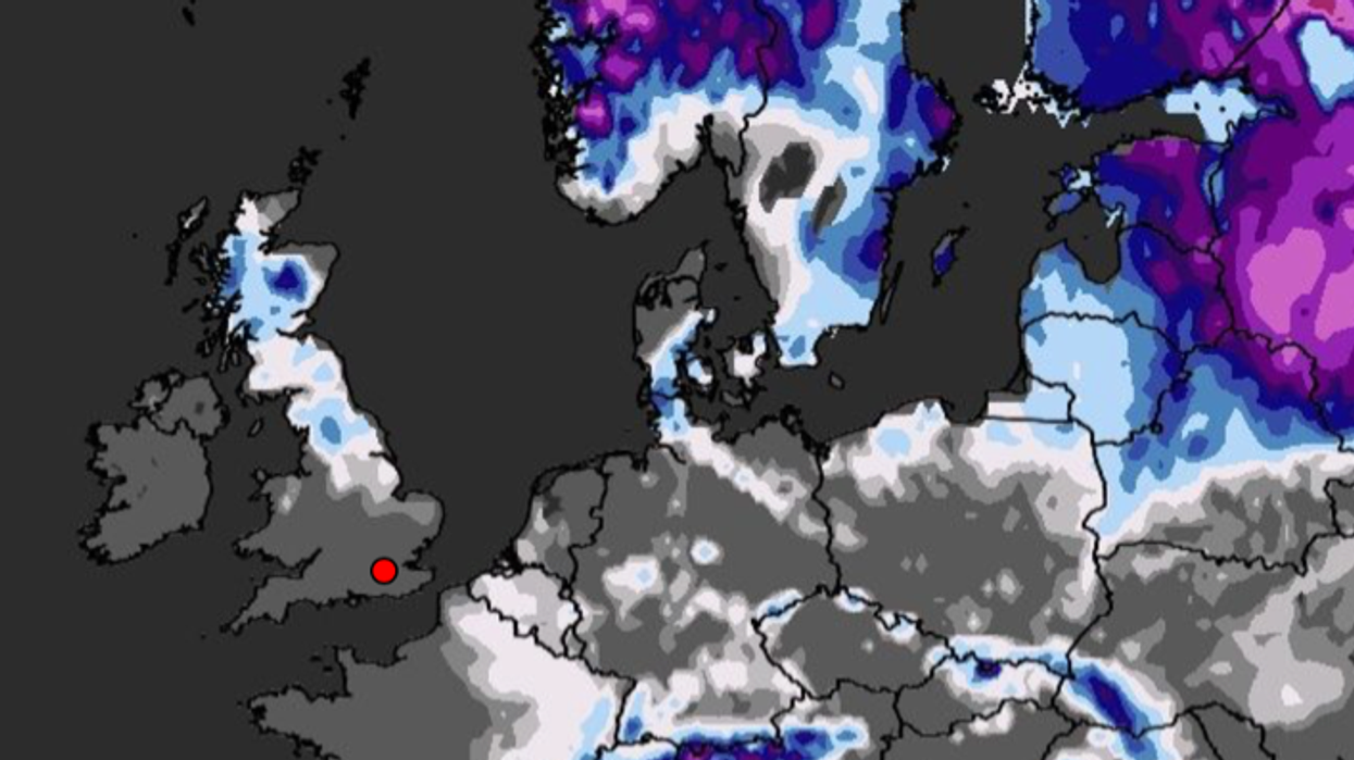
Snow is expected across widespread areas of the UK by mid-March
|WX Charts
Jim Dale, meteorologist for British Weather Services, said: “From Sunday onwards we are going back into the freezer, and I expect the cold weather to hold out for a fortnight at least.
“The first stage will be the arrival of cold air which will bring outbreaks of snow mainly to northern regions but potentially more widely.
“During this period, we could get the odd low-pressure system popping up to the south, and if that happens, we could see sudden heavy snow similar to the cold snap which happened just before Christmas.
“Without doubt we are about to take a leap back into winter."
Northerly winds will pour in from Greenland and the Arctic, brushing Scandinavia and the Nordic regions before engulfing northern Europe.
After the initial cold plunge, a period of heavy snow could be poised to strike Britain later this month as mild and cold air masses lock horns in battle.
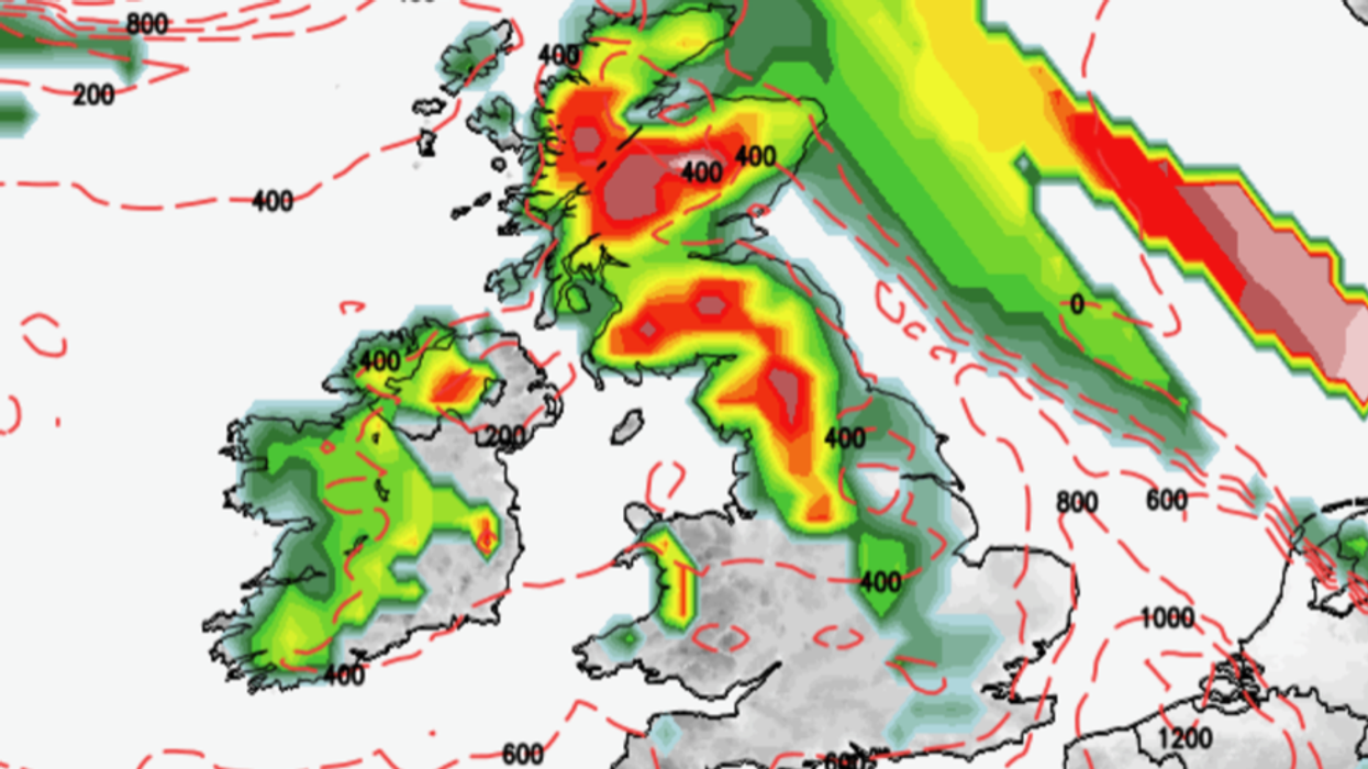
Heavy snow is expected across much of the UK within two weeks
|Netweather
Mr Dale, author of ‘Weather Or Not?’, said: “In the run up to mid-month we expect some frontal activity coming in from the Atlantic and the south-west and this is going to battle with cold air which will still be over the UK.
“There is a chance of further significant snow from this, again mainly in the north and over Scotland but it might reach further across the country.
“The past month has been relatively quiet for February, so what we are going to see is an example of the weather’s balancing effect, with a real taste of winter returning in March.”
Temperatures could hit -10C in Scotland and the north through the cold snap, with lows of between -2C and -6C likely elsewhere, he added.
Bookies have taken an abrupt U-turn on summer arriving early to slash the odds on a spring snow blast.
Ladbrokes is offering 5-4 on -10C recorded this week while giving 7-4 on the coldest March on record.
Spokeswoman Jessica O'Reilly said: "March is getting off to a miserable and freezing start, and unfortunately the odds suggest it's not going to get any better any time soon."
Government forecasters this week sounded the alarm for an imminent cold snap driven by the SSW event.
Met Office deputy chief meteorologist Mark Sidaway said: “We are expecting an area of high pressure to become increasingly established in an area toward Greenland.
“This will allow a northerly flow to feed colder air into at least the northern and eastern half of the UK bringing wintry showers.
“The extended outlook shows the possibility for a series of areas of low pressure to come across the Atlantic, and these bring the potential for some more widespread snowfall as they encounter the cold air.”
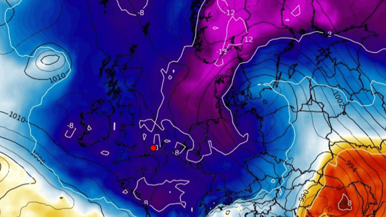
Weather models show temperatures plummeting to -11C in Scotland through the coming days and below freezing countrywide.
They reveal a wall of snow crashing in from the northeast with wintry showers through to mid-month threatening to dump 10 inches in parts.
The Met Office with the UK Health Security Agency (UKHSA) has issued a level-2 ‘alert and readiness’ cold weather health alert which will remain in force from Monday to Wednesday.
It warns a cold north to north-easterly wind and ‘frequent snow’ showers could put the elderly and vulnerable at increased risk.