
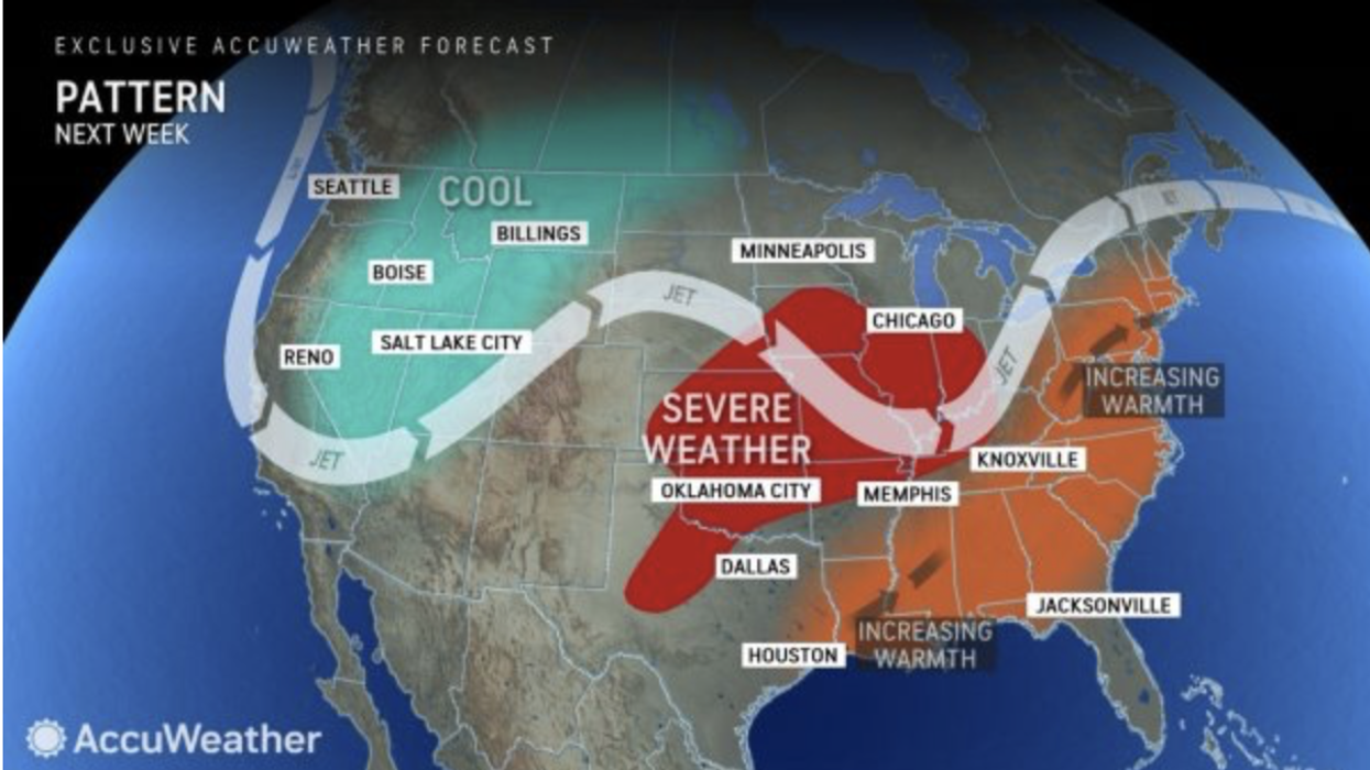


A 90F heat surge clashing with an Arctic pool left from winter will fuel a massive storm assault spanning 12 states.
America’s weather woes will deepen this week as ‘severe’ thunderstorms and 80mph gales threaten to "hit hard".
Eastern states from Texas through Arkansas, Iowa, Tennessee and Kentucky are first on high alert for tornadoes and hailstorms.
Powerful winds and torrential downpours will then head towards the Atlantic coast as clashing air masses destabilise the atmosphere.
The Midwest will also be hit hard
|AccuWeather
It is the latest round in a spate of brutal storms to hit the US since spring began, driven by the jet stream ploughing through atmospheric battle ground.
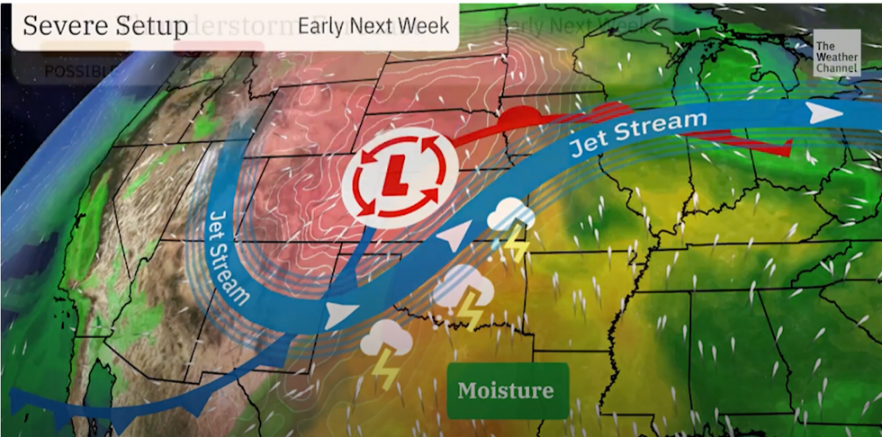
A meteorologist for The Weather Channel said: “The ingredients are in place for what could be a severe weather event early in the week across the Central Plains.
“This severe episode is likely to start on Monday afternoon, and the threat pushes east on Tuesday.
“We are keeping our eyes on this weather threat from the start of the week.”
Severe weather across America is being driven in part by tropical air from the south crashing against cold air to the north.
A pool of Arctic air left from winter remains over north-western states as the south welcomes tropical gusts from the Gulf of Mexico.
Where the two meet, the jet stream will fire up, helping strengthen and steer storms across the country.
LATEST DEVELOPMENTS:
Storms move west
|The Weather Channel
Families and businesses are warned to prepare for damage to buildings and travel chaos.
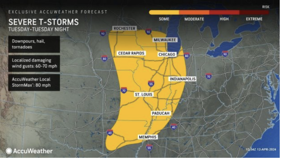
A spokesman for AccuWeather.com said: “Warm and humid air moving in from the south is forecast to clash with cooler and drier air approaching from the northwest, sparking thunderstorms in more than a dozen states early in the week.
“The threat of severe weather will start on Monday afternoon, with thunderstorms forecast to develop from the Texas Panhandle along the Plains to Nebraska.
“On Monday night, storms will move east through the Missouri River Valley and Iowa, and also into parts of Kansas, Oklahoma and northern Texas.”
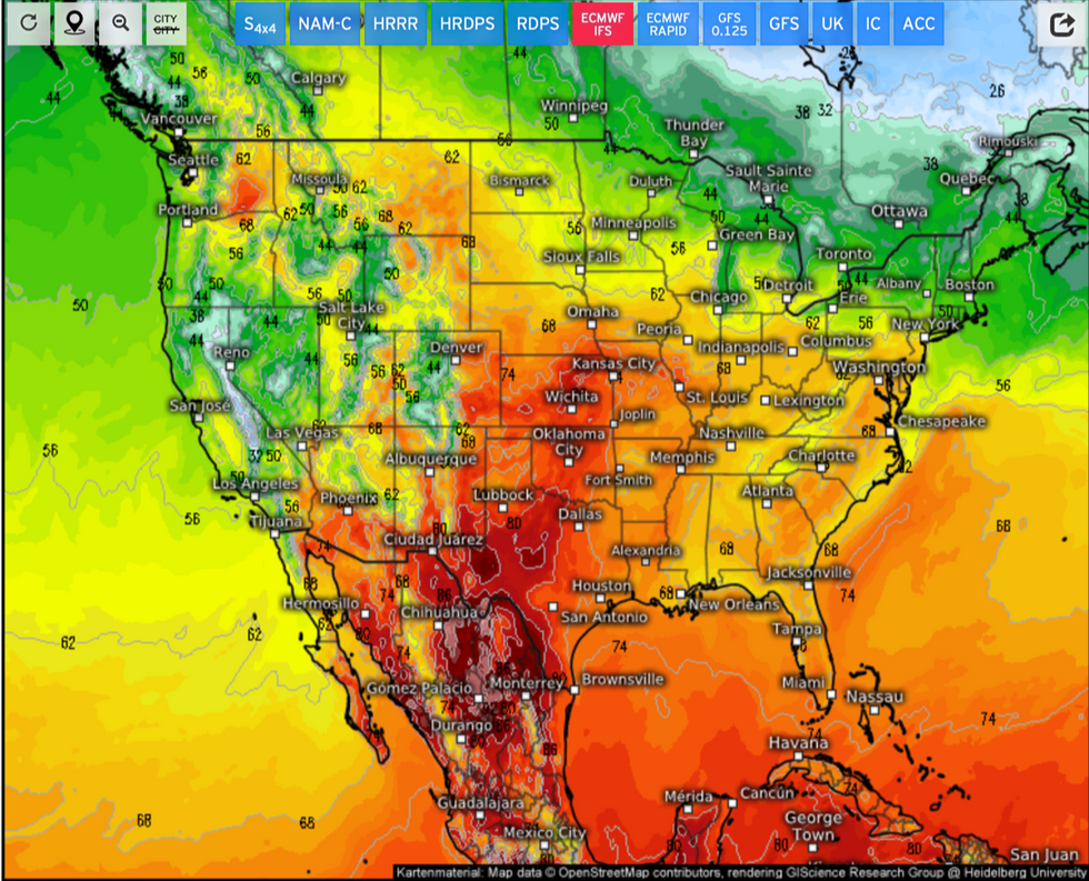
Unstable atmospheric conditions will be driven by huge temperature contrasts across the United States.
Thermometers are forecast to hit 90F in parts of the south this week while the northwest hovers around 40F.
Temperature contrasts across the US
|Weather.US
Low pressure storm systems will also strengthen as they tumble over mountains and hills–a process called lee cyclogenesis.
A spokesman for the National Weather Service (NOAA) said: “As the system spreads into the Plains, lee cyclogenesis will help to deepen the surface low pressure system, with intensifying moist southerly flow from the Gulf leading to widespread shower and thunderstorm development by Monday evening.
“A broad area of well above average temperatures will continue across the
Central and eastern US on Sunday and Monday.
“Some 90s will even be possible over the central and southern High Plains.”
Jim Dale, meteorologist and co-author of ‘Surviving Extreme Weather’ added: “These storms are being fuelled by cool air to the north meeting the hot, moist air coming up from the south, and they may spread outside regions where we usually expect to see them at this time of year.”