
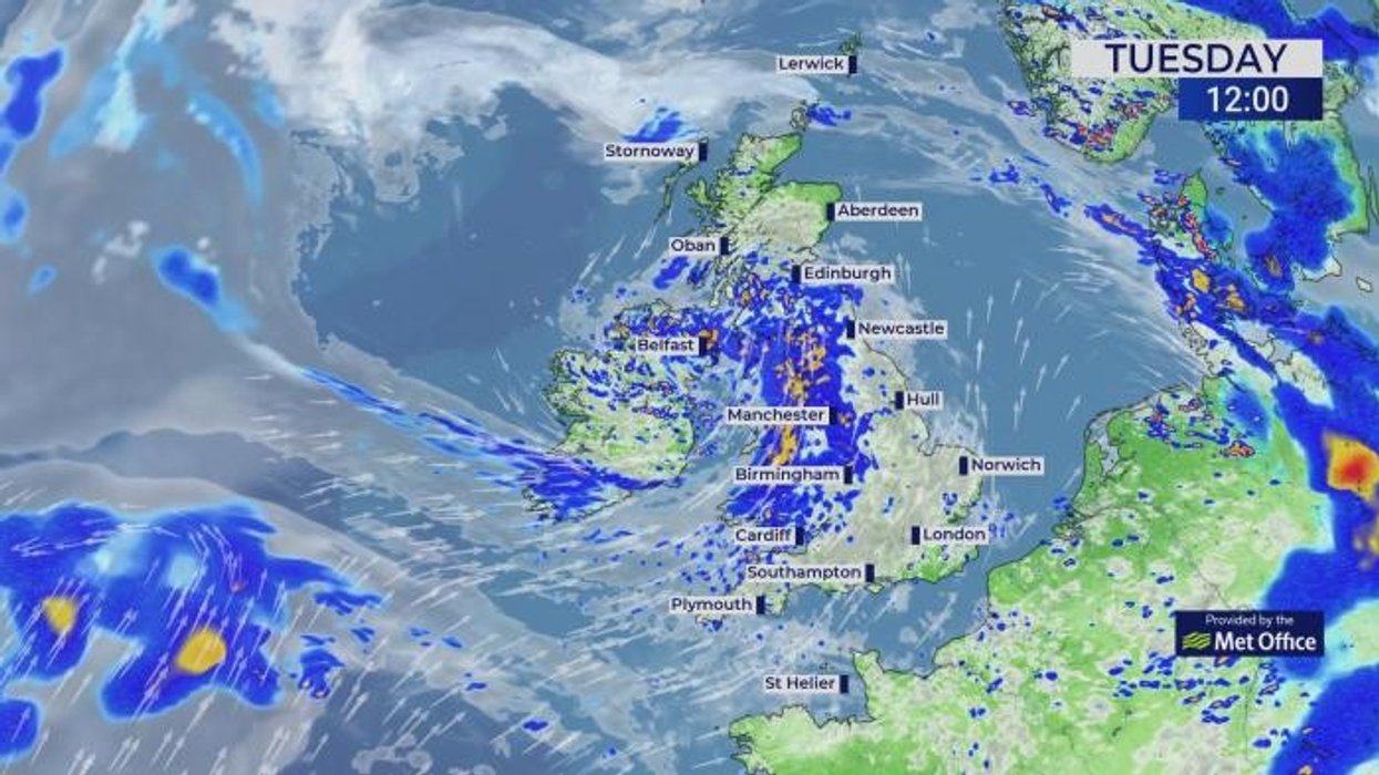


A cyclonic storm double whammy will pelt Britain with thundery downpours putting parts of the country on alert for floods.
Heavy rainfall will wash away the last dregs of the heatwave as the gates open to the turbulent Atlantic.
High pressure, the driver of hot, dry weather, will retreat in favour of low-pressure cyclonic storm systems.
After temperatures of 30C-plus through last week, the mercury will nosedive below average.

A cyclonic storm double whammy will pelt Britain with thundery downpours putting parts of the country on alert for floods
|NETWEATHER
Met Office meteorologist Greg Dewhurst said: “Low pressure comes in from the Atlantic and heavy rain pushes eastwards with longer spells of rain, heavy downpours and some rumbles of thunder.
“There will be some brighter spells around this area of low pressure, but a lot of rain, which is needed rain in places, and Tuesday will be feeling quite cool with temperatures below average in the north, so it will feel much cooler than of late.
“The rest of the week remains mixed, but temperatures do start to creep up a little as we end the week.”
Roller-coaster temperatures will see a cooler spell this week give way to another weekend warm spell.
Heavy rain will be driven by two low-pressure systems bookending the week as the heatwave heat-dome fizzles.
Temperatures in the 20Cs will sink into the teens mid-week before lifting again ahead of the weekend.
Jim Dale, meteorologist for British Weather Services and co-author of ‘Surviving Extreme Weather’, said: “We will be dipping in and out between cooler and warmer spells for the next week or so.
“But in the meantime, heavy rain and thunder will bring the risk of flooding to parts of the country, especially where the ground is dry from the recent heatwave, where rainwater will run off during heavy downpours.
“Two low-pressure systems will bring the unsettled weather, one at the start of the week and the next before the weekend.”
LATEST DEVELOPMENTS:
Energy in the atmosphere from the hot weather will ignite violent thunderstorms, he warned.
He said: “Ground and sea temperatures are high after the hot weather, and this puts a lot of energy into the atmosphere.
“This will help drive volatile conditions and the risk of thunderstorms through the coming days.”
Despite a cooler spell, bookmakers are watching thermometers for the return of the heat.

Heavy rainfall will wash away the last dregs of the heatwave as the gates open to the turbulent Atlantic
|WXCHARTS
Coral’s John Hill said: “With more heatwaves set to bake the nation later this summer, we make it odds-on for the UK’s highest ever temperature of 40.3C being broken this year.”
Much of the UK will feel cooler from today with rain turning more widespread through the middle of the week.
Jason Nicholls, lead international forecaster for AccuWeather, said: “It will be more widely cooler on Tuesday and Wednesday, and mid-week will bring a greater chance of scattered showers.
“While there will be sunny periods on Friday, isolated showers are still possible, with more rain likely at the weekend.”
As Britain cools from its third heatwave in as many weeks, experts say exceptional summer heat may be the new norm.
The Royal Meteorological Society’s latest State of the Climate report warns regular extreme weather events could result from a 0.25C rise in average UK temperatures since the 1980s.
Professor Liz Bentley, chief executive of the Royal Meteorological Society, said: “This latest edition of the State of the UK Climate report reinforces the clear and urgent signals of our changing climate, rooted in robust observational science.
“It documents changes in temperature, rainfall, sea level, and weather extremes that are affecting lives, infrastructure, and ecosystems across the UK.”