


Britain’s heatwave will fizzle in a tangle of cold fronts, plunging temperatures below the mid-summer norm.
Chilly gusts, rain and thunder will hit northern Britain and Scotland this week while the south holds on to the dregs of warmth.
Highs in the 30Cs will give way to temperatures in single figures while the warmest regions scrape the 20Cs.
A low-pressure twin system dragging cold fronts across the UK will spark heavy rain and thunder.
Jim Dale, meteorologist for British Weather Services, said: “We are going to see much cooler conditions for many for the start of the week, and while temperatures are likely to lift mid-week, we are looking at cooler, more showery weather.
“There are two low pressure systems with associated fronts that are going to influence the weather this week, bringing quite a change from the heatwave.
“Through the week, we are looking at swapping between cooler conditions and the odd burst of warmth.”
After weeks of clear, rainless skies in parts of the country, torrential downpours threaten the risk of floods.
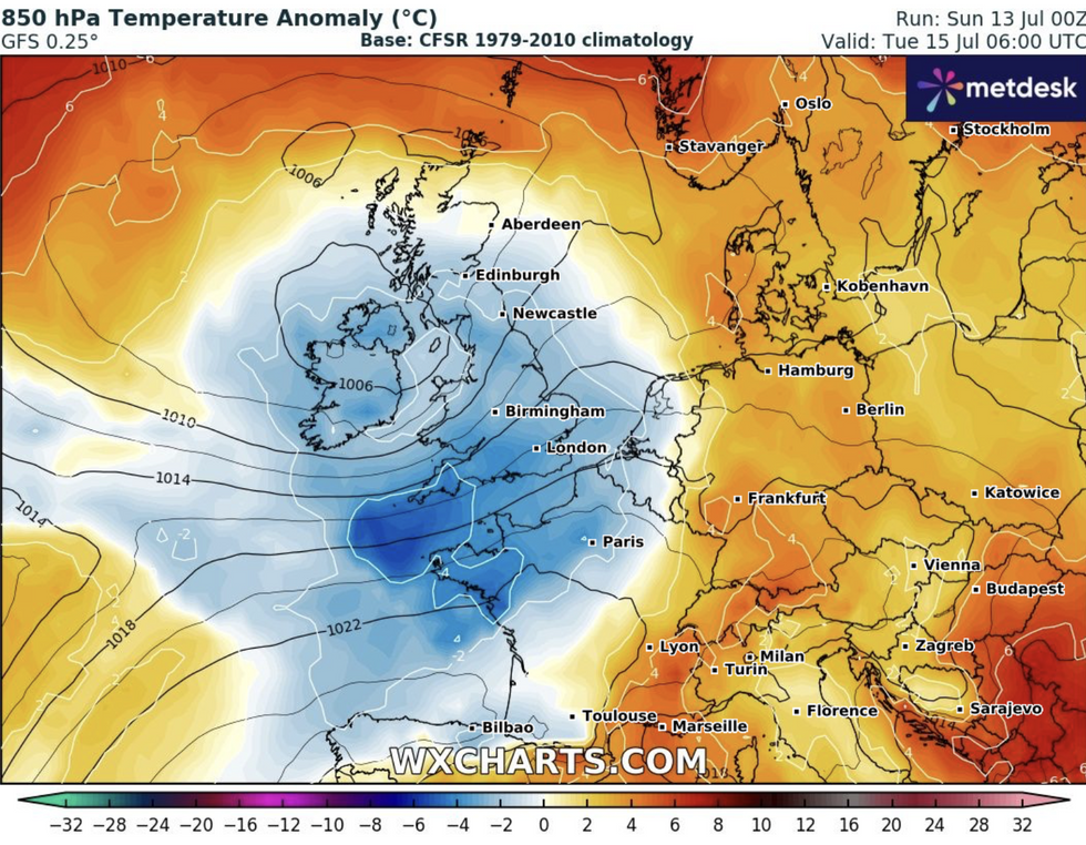
Britain's heatwave will disappear
|WX CHARTS
Energy in the atmosphere from the heatwave will also trigger thunderstorms, Dale warned.
He said: “The heat in the sea and ground left from the hot weather is going to mean a lot of energy feeding into the atmosphere and this is going to drive heavy rain.
“Through the start of the week, there will be the added risk of thunderstorms.”
Western and northern regions will be first in line for the cooler, wetter weather as cold fronts move in from the Atlantic.
Southern and southeastern England will be driest and warmest, with temperatures today nudging 30C.
LATEST DEVELOPMENTS: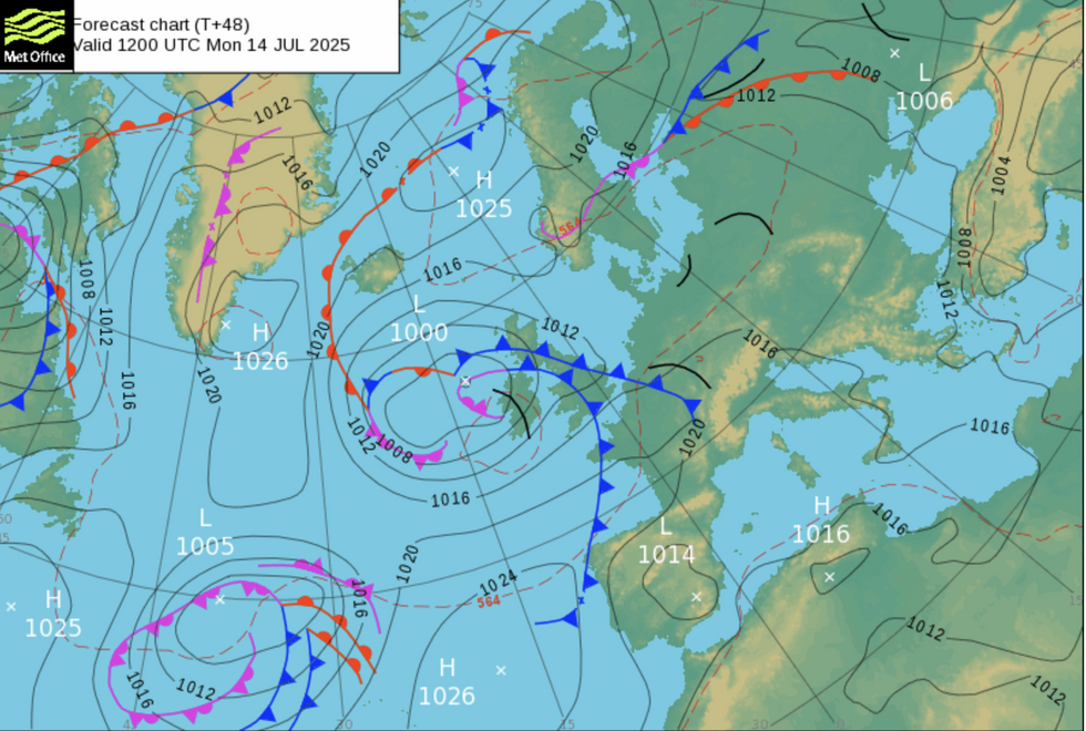
Weather fronts cross Britain
|MET OFFICE
Met Office meteorologist Kathryn Chalk said: “Showery outbreaks of rain will push their way eastwards, moving into northern England and Scotland, and here the rain is going to be heaviest and most persistent with the odd rumble of thunder and perhaps with some thunderstorms breaking out across central England.
“It will be driest across the southeast where it is still going to be feeling hot with temperatures around 29C or 30C, but in the west, cooler and fresher air will return temperatures closer to average at 22C to 24C.”
Scotland and northern England this week could see thermometers dip below the 21C average.
Unsettled Atlantic weather patterns will usher chilly winds and rain in the run-up to mid-week, experts warn.
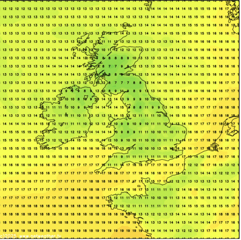
Temperatures dip
|NETWEATHER
Netweather’s Nick Finnis said: “Temperatures will be below average for many, reaching the high teens at best, maybe 20C with some brightness, after temperatures have been up to 10C above the average maximum over the last few days.”
Despite the chilly forecasts, bookies are still looking for a July scorcher with Ladbrokes slashing the odds on further records tumbling.
Spokesman Alex Apati said: “The scorching start to the month looks set to continue, and as a result, we've slashed odds on a record-breaking hot July.”
AccuWeather’s lead international forecaster Jason Nicholls said: “It is still warm in the south on Monday with thundery showers, mainly in the north and west.
“It will be cooler in the north on Monday and cooler across the UK on Tuesday and on Wednesday with scattered showers.
“Some of these will be thundery.”