


A massive -20C Scandinavian ‘cold pool’ will drive days of torrential downpours in what is feared could be a Storm Babet copycat deluge.
It shows a similar pattern Storm Babet last week, prompting the Met Office to issue further warnings for heavy rain, flooding, and possible disruption.
WATCH HERE: Nathan Rao discusses the aftermath of Storm Babet
Wet and windy weather will hold out through the weekend before cold air slides into Britain plunging northern regions into an early winter chill with snow over the hills.
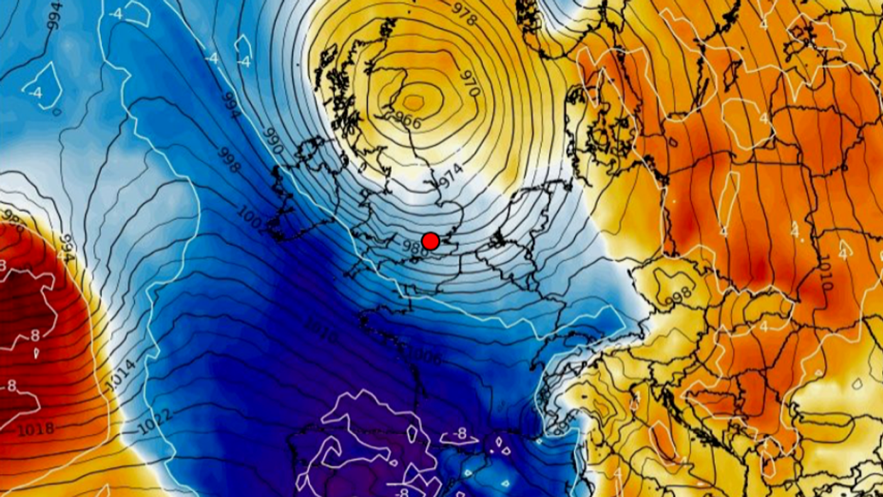
Jim Dale, meteorologist for British Weather Services, said: “There is a huge blocking high over Scandinavia associated with a pool of cold air which will be bringing temperatures of between -17C and -20C to the region.
“What this means for the UK is that when this low-pressure system comes in from the west, it will bump up against high pressure and stall over the UK.
“It is looking similar to Storm Babet, and that means there is going to be more rain, especially for Scotland.”
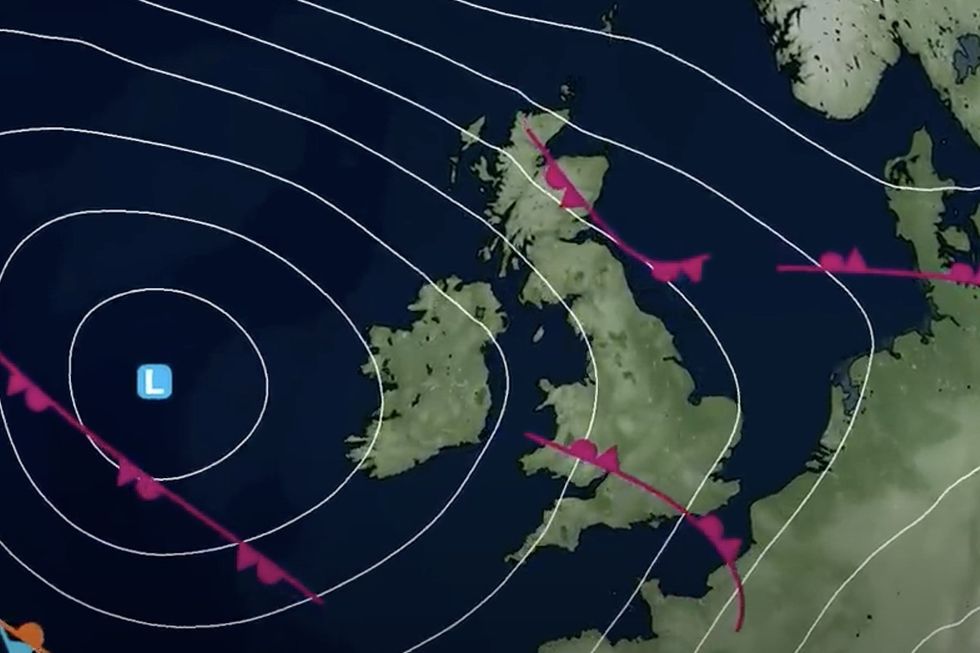
Cold pool over Scandinavia holds low pressure over the UK
|WX charts
Stormy weather will be driven by usually high sea temperatures ploughing volatile energy into the atmosphere, he said.
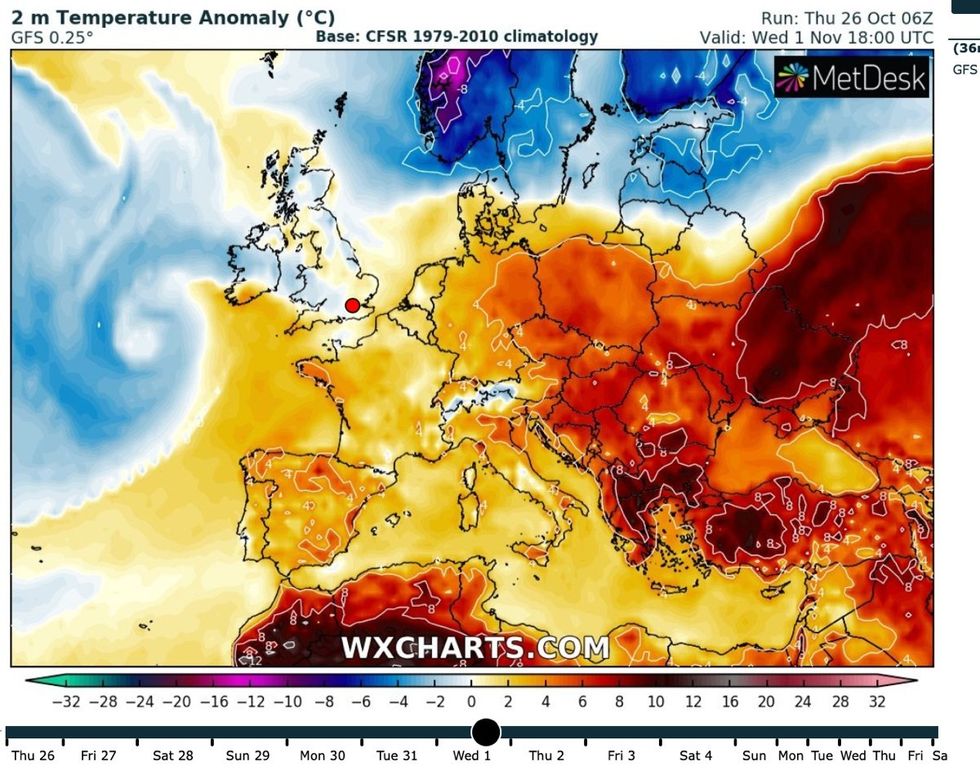
After wind and rain has cleared to the east of Britain on Monday, a plunge of cold air will follow in its wake.
Temperatures will nosedive across Scotland and northern Britain, bringing the risk of snowfall across high ground.
Mr Dale said: “The continued wet weather is the result of the sea temperatures remaining higher than normal after the summer heat.
LATEST DEVELOPMENTS:
Cold air comes down next week
|WX charts
“This ploughs energy into the atmosphere, and much like a pan of water on the stove, moisture evaporates and turns to rain.
“There is a bit of a wintry element to this, with northern regions including Scotland possibly going to feel colder as we go through next week with the risk of frosts and some wintriness over higher ground.”
The Met Office has issued weather warnings through the weekend for more than six inches rain across eastern Scotland.
A separate warning for rain is in force on Sunday across south-eastern England where almost three inches threaten flooding and travel disruption.
A further risk of 55mph gales could trigger power cuts and damage to buildings and trees, according to the Met Office.
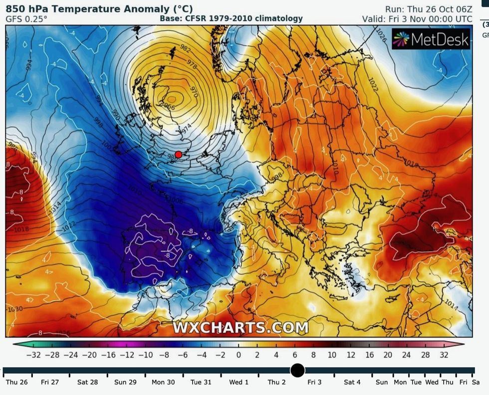
Meteorologist Alex Burkill said: “It is a mature low that is going to dominate the picture.
“Saturday is another unsettled picture, we are still under the influence of that mature low to the west and so it is going to stay blustery and windy at times and there will be further outbreaks of rain across the bulk of the UK.
“Lots of places are likely to see some significant rain as we go through the next few days.”
Met Office describes a huge low pressure system coming into Britain
|Met Office
Another low-pressure to the west could bump into a ‘blocking high’ to the east in a similar set-up to Storm Babet, he warned.
Although weather models are yet to agree on the exact meteorological set up with the impacts expected to be less severe than last week, he added.
He said: “If this does come off, it is not out of the question that we would get a blocking high towards Scandinavia which could stall the progress of this low moving across the UK, and that is what we had with Storm Babet.
“I’m not suggesting that it is going to be as extreme, but it could stall a little bit and rain could come over the north and the east of Scotland where we had that rain last week.”
Northern regions will feel the brunt of the colder weather while the south hangs onto the higher temperatures, he warmed
He said: “There is something a little bit colder spreading across northern parts as we head into next week, but we will be holding onto something a bit milder across southern areas.
“As we look further ahead, we are going to see a bit of colder air coming in especially across northern parts.”