


A gigantic bubble of hot air from the Mediterranean will smother Britain this weekend turning the thermostat up on another freak autumn heatwave.
A near-30C tropical blast could rival last week’s historic scorcher and once again put September records at risk.
A snaking ‘warm front’ stretching across the country will put southern regions in direct fire of the heat blast, experts say.
Wall-to-wall sunshine and balmy temperatures await sun-loving Britons, although a sting in the tail threatens violent thunderstorms.
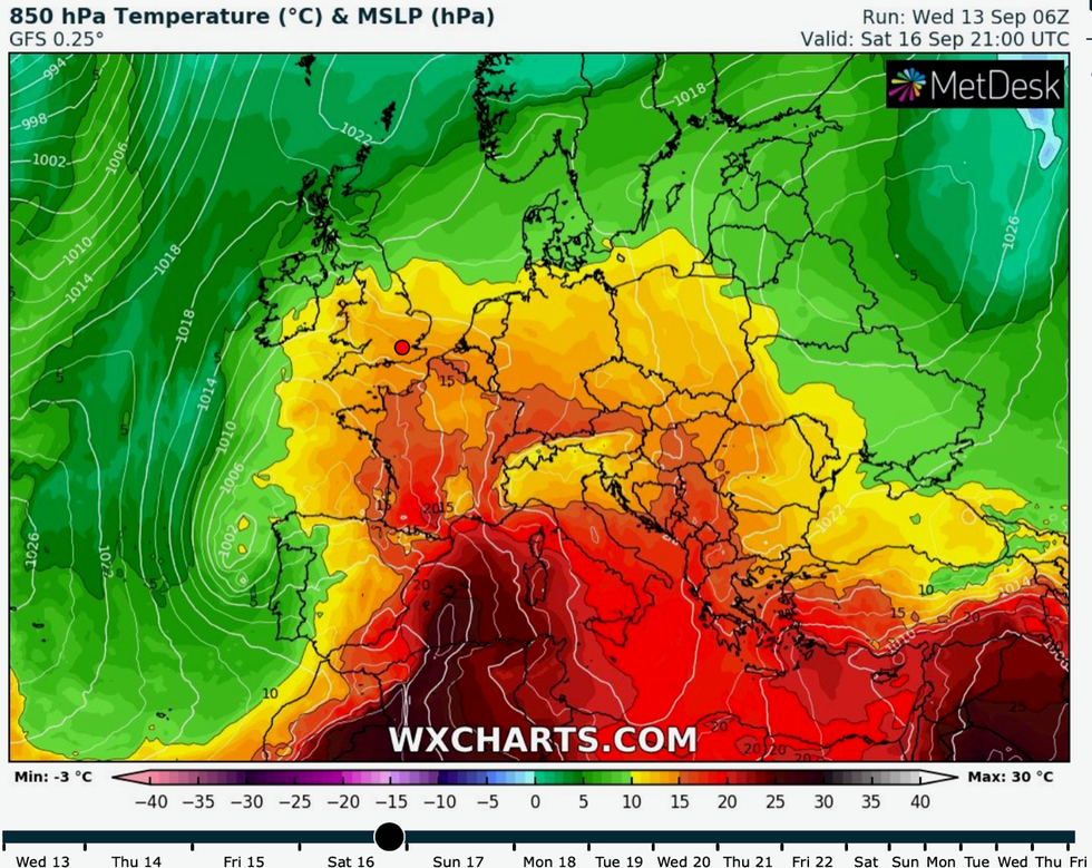
Heat builds at the weekend
|WX Charts
James Madden, forecaster for Exacta Weather, said: “Confidence is high for another influential area of high pressure to raise temperatures from the end of this week and through the weekend.
“We are looking at heat which could be similar in nature to the recent heatwave in terms of maximum temperatures and duration.
“Even later in the month there is the potential for high pressure to build and bath the country in further wall-to-wall sunshine and balmy temperatures.
“This could also see some more September temperature records fall by the end of the month.”
Heat will be pulled in from France and the western Mediterranean over the coming days as low pressure moves to the north of the UK.
A huge warm front stretching from Scandinavia to the French coast will steer the boiling air mass across southern Britain.
The mercury will start to rise from today with Friday and Saturday to bring the hottest temperatures.
Parts of the country could simmer in highs of 28C, and although experts think 30C may be just out of reach, it is possible.
Jim Dale, meteorologist for British Weather Services, said: “We are going back to sweaty nights and very warm days with temperatures on Friday and Saturday possibly reaching 28C, and while 30C seems just out of reach, you never know.
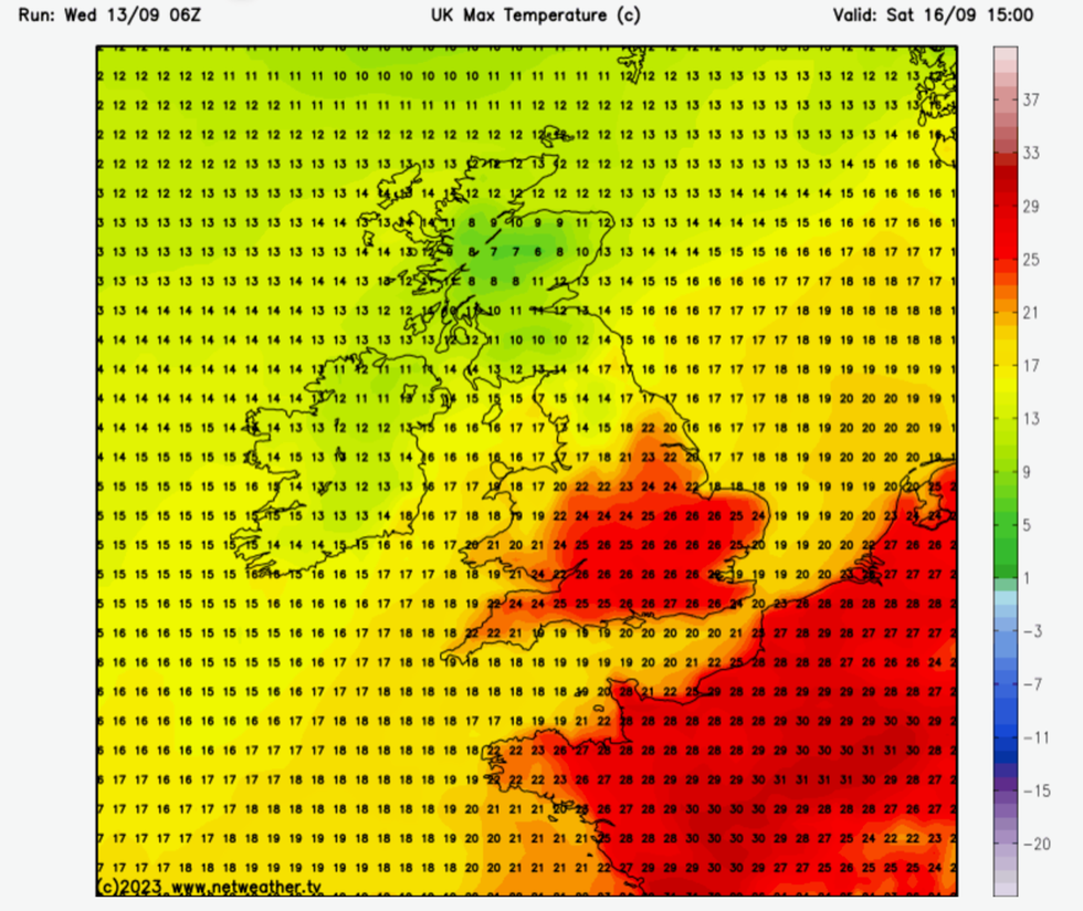
Temperatures in the high 20Cs
|Netweather
“Air is being pushed up from France and the western Mediterranean as a cold front moves across the country making way for a warm front, with the peak of the temperatures probably likely at the weekend.
“It is likely to turn cooler by Sunday, and then we are back to a pretty normal, mixed picture of September weather.”
But the sudden injection of extreme heat and moisture is likely to go bang with thunderstorms forecast ahead of next week.
Mr Dale, author of ‘Weather Or Not?’, said: “This hot spell is going to come with a sting in the tail, and there could be some heavy, thundery downpours on Sunday.
“It does start to go downhill later in the weekend, and while it may still be warm in the south and the southeast, the rest of the country will turn cooler and more unsettled.”
The highest temperatures will hit the southern half of the country, while Scotland and the north will stay cooler.
However, temperatures in parts of the south could nudge the 30C-mark, according to the Met Office.
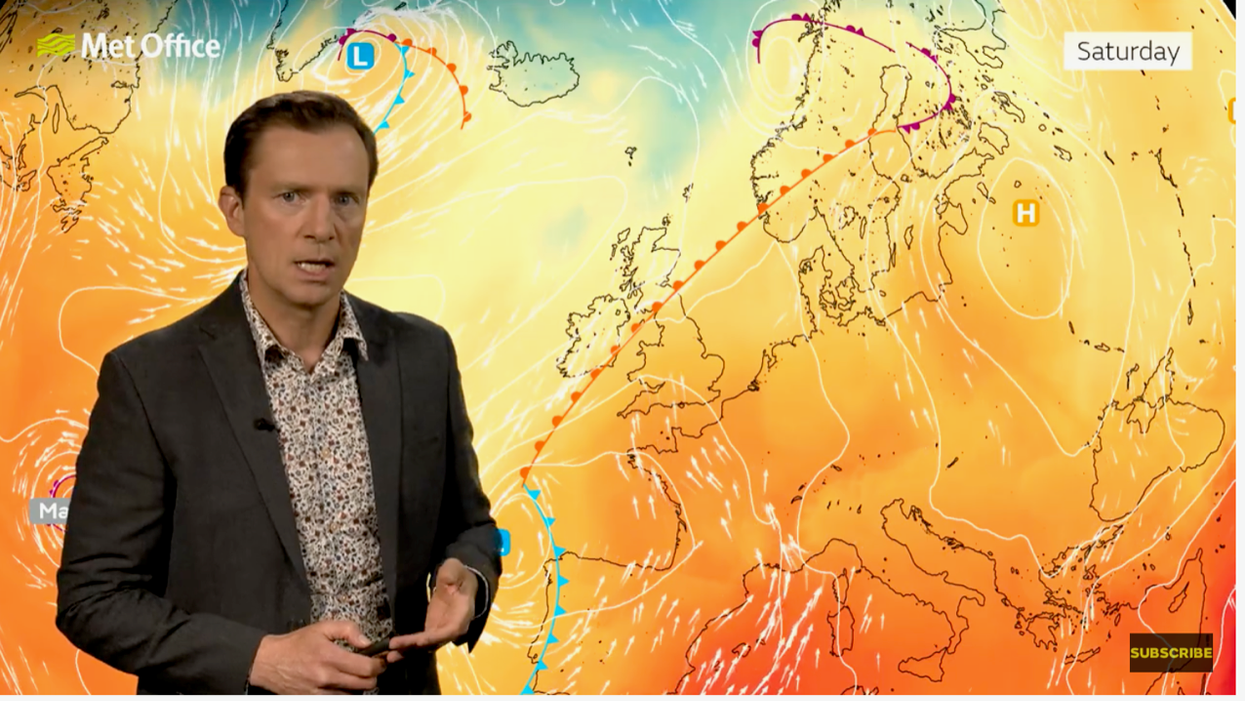
Met Office meteorologist Alex Deakin said: “The heat is really starting to build in the south.
“To the south of the weather front it is going to be warming up, temperatures will be getting into the mid-20Cs, and we could even approach 30C by Saturday although further north will be about 10C cooler.
“The jet stream is diving down in a trough and that is going to affect our weather as it will push up warmer conditions from the south.
“A combination of the heat building with a bit more moisture and the jet stream pushing northwards may well trigger some more thunderstorms.”