


A brief meteorological U-turn will bring ‘six hours’ of dry weather before Britain resumes the spin cycle.
A quarter-day window will offer pause from the endless deluge which has drenched swathes of Britain in rain every day this year.
But blink and you’ll miss the rain-free hiatus, they warn, earmarked for the early hours of Saturday.
Met Office meteorologist Aidan McGivern said: “We are talking about a six-hour period where the weather is drier and brighter on Saturday before the next system comes along.
TRENDING
Stories
Videos
Your Say
“There is a big change on the way into the weekend with a ridge of high pressure and a brief window of finer weather, but it is going to be chilly.
“Across parts of Scotland on Sunday night, there will be a period of snow mostly over the hills before it gets replaced by rain coming in from the west and milder air.”
Temperatures over the next 24 hours will plunge from the north, he warned, with southern England braced for a weekend winter blast.
Snow will fall mainly to the hills of Scotland and northern England, McGivern explained, with a slight risk of sleet to low ground.
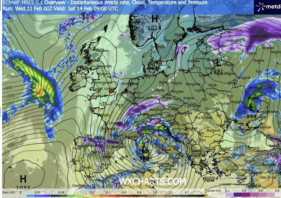
Temperatures over the next 24 hours will plunge from the north
|WX CHARTS
He said: “We are going to see cold air push in across Scotland, and then during Scotland and into Friday, that cold air sinks further south across all parts of the UK.
“That means that we are eventually going to stop talking about rain and start talking about hill snow.
“On Thursday night, more of that snow falls over the hills, and it is through Friday that we have a mixture of rain, sleet and hill snow.”
A ‘volatile’ mix of meteorological events over the next three days will bring snow, ice, freezing temperatures and more rain.
LATEST DEVELOPMENTS
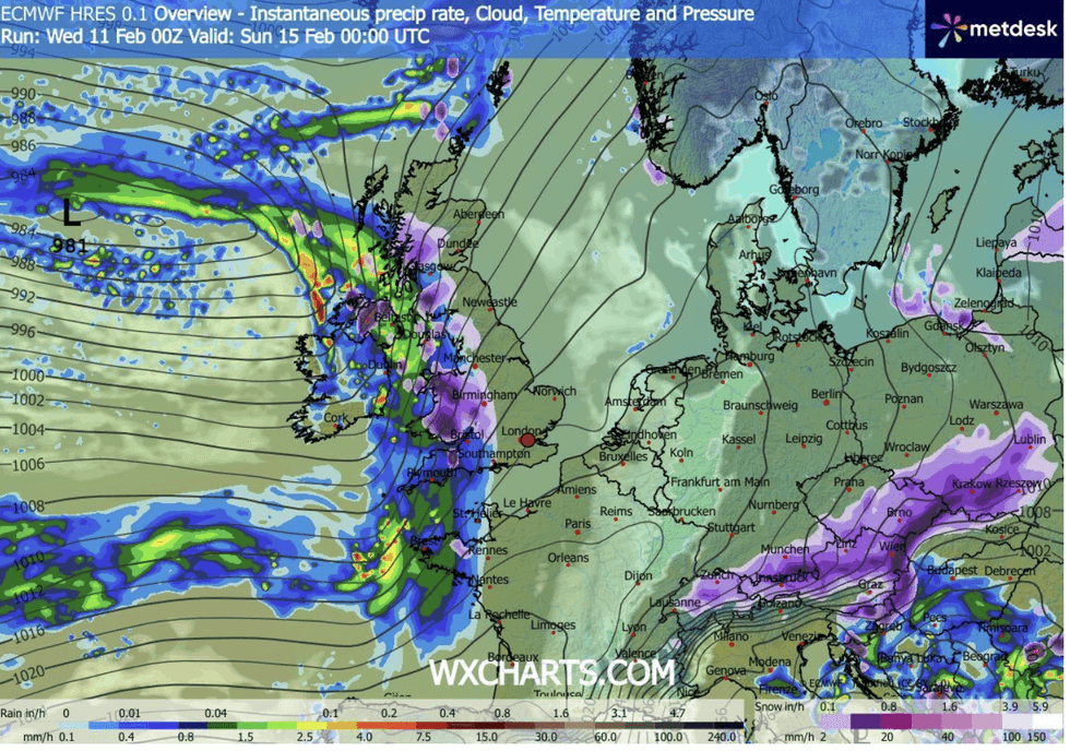
Plunging temperatures will fizzle passions on the most romantic night of the year
|WX CHARTS
Plunging temperatures, rain and snow this weekend will fizzle passions on the most romantic night of the year.
And the outlook beyond the middle of the month is for more downpours as Britain squelches through one of its wettest ends to winter.
Jim Dale, meteorologist for British Weather Services and co-author of ‘Surviving Extreme Weather’, said: “Valentine’s Day is looking like falling during the peak of the cold weather, so people should expect a freezing night.
“We could see temperatures of minus 10C over night, and lower with the wind chill, and with the risk of snow not only to high ground, but to lower levels.
“We also have low pressure coming in from the west bringing moisture into that cold air, so we are looking at a volatile mix of weather conditions through the end of the week and into the weekend.”
After the weekend, the weather will reset to bring another relentless deluge in from the Atlantic.
A Met Office spokesperson said: “Unfortunately, this break in the unsettled pattern won’t last long.
“The Atlantic is expected to reassert itself by early next week, pushing milder and more changeable conditions back across the UK.
“Nonetheless, Saturday offers a brief window for calmer, clearer weather before the next round of frontal systems arrives.”