


Britons will wade through another week of rain before the promise arrives of something "spring-like", meteorologists have claimed.
The shift in weather during late February will see the clouds eventually part in a blaze of glory.
The battle between cyclonic Atlantic storm systems and a calming "anticyclonic high" to the east is about to climax in a sunny breakthrough.
Met Office meteorologist Alex Burkill said: “As we go through the end of the week, there are signs of high pressure building to the southwest.
TRENDING
Stories
Videos
Your Say
“As we go through the end of February, there are tentative signs for high pressure building and the weather settling down, so there could be something a little more spring-like.
“This week, the cyclonic pattern, indicating lower than average pressure, is more likely, so we stick with the unsettled weather, but next week, towards the southwest, there are signs that high pressure could build.”
But after a season of unpredictable weather peppered with storms and Arctic outbreaks, continued uncertainty gives ‘no guarantees’, he added.
Meanwhile, Britain is buttoning raincoats for another five-day deluge, with persistent downpours forecast into the weekend.
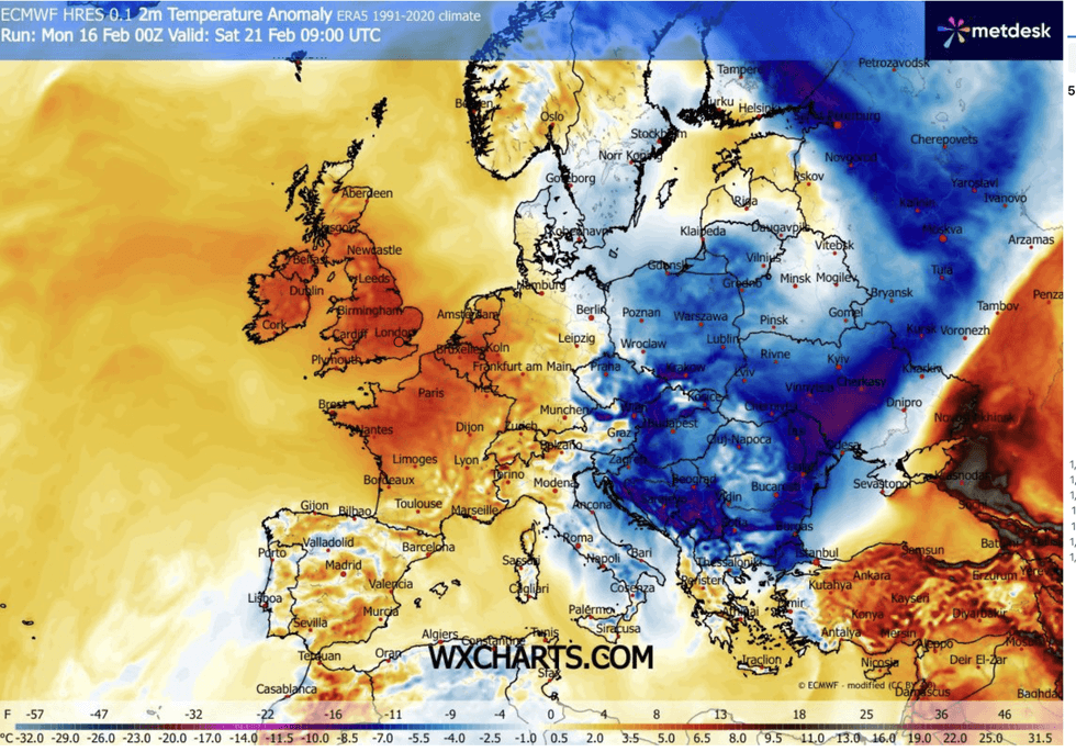
Warmer weather could arrive as early as the weekend
|WXCHARTS
Western regions already drenched from weeks of showers will enter the crosshairs for the soaking.
The Environment Agency has scattered the country with more than 200 flood alerts and around 80 more serious flood warnings.
A spokesman said: “Ongoing impacts from groundwater are probable for parts of the South of England through the next five days.
“Land, roads and properties could flood and there could be travel disruption.”
LATEST DEVELOPMENTS
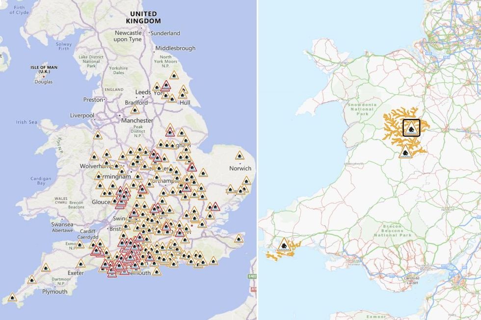
More than 200 flood warnings had been issued across England and Wales yesterday
| ENVIRONMENT AGENCY/NATURAL RESOURCES WALESWhile parts of the country brace for the downpours, elsewhere could feel the first flush of spring’s arrival.
Jim Dale, meteorologist for British Weather Services and co-author of ‘Surviving Extreme Weather’, said: “There will be some nice weather around this week, with some dry spells and sunshine.
“But the overall theme is for more of what we have seen over the past weeks, which is low pressure largely dominating with an unsettled changeable picture.
“Flooding will continue to be a risk across western regions which are in direct fire of low pressure carrying rain as it comes off the Atlantic.”
As rain moves into colder air over Britain, snow will fall over the Highlands of Scotland and northern England, he warned.
He said: “There is going to be the risk of snow in parts of the country through the week with widespread frosts, especially in the glens and highlands to the north.
“Temperatures in parts will really go downwards as we get the influence of Polar air still driving the cold weather in the UK.
“Towards the end of the week, however, there are signals for a change with temperatures rising and the rain easing.”
However, the long-term outlook is promising, with the Met Office promising a ‘quieter’ start to spring.
A spokesman said: “Looking further ahead, even beyond the ten‑day window, there are early indications that high pressure to the southwest could become more influential toward the end of February.
“While not guaranteed, this raises the possibility of quieter, more spring‑like conditions as meteorological spring approaches.”