


Britons will have just hours to enjoy the ‘sunniest day of the year’ before temperatures plunge ahead of the next deluge.
Despite a bitter start, Saturday will deliver a longed-for break in the rain as the clouds part in a blaze of cheer.
But the sun-starved nation will have just hours to soak up the rays with the rest of the weekend shaping up for more rain.
And couples heading out on Valentine’s night face plunging temperatures, ice and the risk of snow.
TRENDING
Stories
Videos
Your Say
Met Office meteorologist Alex Burkill said: “Most places on Saturday will have their sunniest day of the year so far, but it won’t last as cloud is building from the west with a frontal system, and with the fine sunny weather, there is going to be a chill.
“Valentine’s Day will have a cold frosty start, and we could get to negative double figures, and then it is looking largely dry.
“Later on, a weather front comes in from the west, and on the leading edge of that rain, we are likely to see some significant snow, and where we don’t see the snow there is rain in places, and a relatively modest amount of rain could cause some issues.”
Despite the sunshine, temperatures on Saturday could dip to minus 10C in northern Britain and below freezing further south.
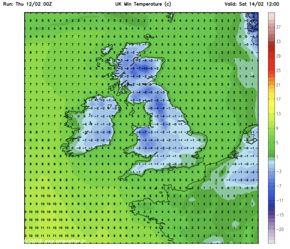
The sun-starved nation will have just hours to enjoy the rays
|NETWEATHER
Scotland is on notice for 10 centimetres of snow to settle over high ground with the risk of a flurry further south.
After the cold weekend, next week will see temperatures lift slightly as wet weather returns from the west.
Burkill said: “While temperatures may lift a little bit on Sunday, there will be some colder air coming in on Monday, and it looks like low pressure will be nearby.
“But we are switching it up a little bit, we are going back to what we are more used to with low-pressure systems making their way across.
LATEST DEVELOPMENTS
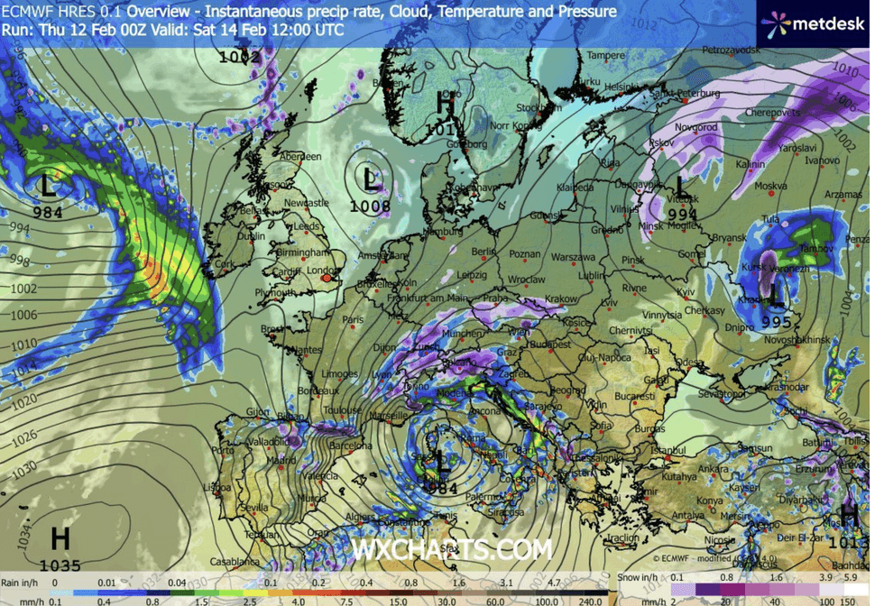
Britons are bracing for another deluge
|WX CHARTS
“During the middle of the week, there is one model that has a particularly deep area of low pressure that could bring some wet and windy weather across many parts.”
Courting couples face a miserable time on Saturday night ahead of the Valentine’s freeze which threatens a ‘proper winter blast’.
Unstable weather fonts from the west will clash with a plume of Arctic cold to bring a ‘volatile mix’ of rain, wind and snow.
Jim Dale, meteorologist for British Weather Services and co-author of ‘Surviving Extreme Weather’, said: “We are looking at a Valentine’s Day freeze, with temperatures dropping to minus 10C in parts.
“There will be a risk of snow to the north largely, but also further south, with more rain through the rest of the weekend.
“It is a particularly volatile mix of weather conditions going through the weekend and into the start of next week.”
The UK Health Security Agency (UKHSA) has issued a four-day Cold Weather Health Alert across northeastern England.
Plummeting temperatures threaten impacts on the elderly and vulnerable, with ‘minor impacts’ on health and social-care services.
A Met Office spokesperson said: “As winds turn more easterly, colder air will gradually sink southwards, reducing rainfall in the northeast and increasing the likelihood of hill snow across northern England, Wales and Northern Ireland.
“Lower levels may see sleet at times, but accumulations will be confined primarily to higher ground.”