


A five-storm cluster flung towards Britain on a hurtling jet stream threatens another imminent storm nightmare.
As swathes of the country reel from Storm Bram, the next assault is just hours away, experts warn.
Violent winds will drive torrential downpours across already flooded regions this weekend.
A knot of cyclonic low-pressure systems riding the jet stream will spit a dangerously volatile member towards Britain on Saturday.
TRENDING
Stories
Videos
Your Say
Met Office meteorologist Aidan McGivern said: “An area of low pressure is swinging in another frontal system with strong winds, and widespread heavy rain, particularly again to western parts of the UK.
“The Met Office weather models have in excess of 100mm [four inches] and this is worrisome, but other computer models don’t have this much.
“The jet stream is sending low after low through on Saturday and into next week, and Sunday is going to be another very unsettled day.”
Weather models vary on the intensity of the storm and how much rain it is going to deliver.
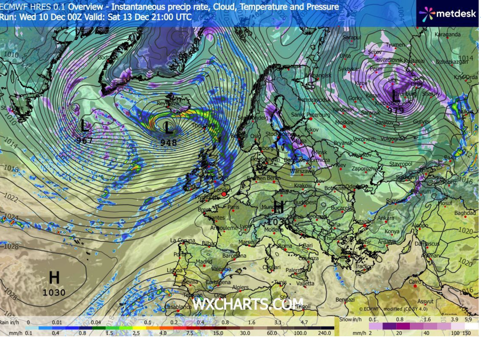
Britain in the firing line for barrage of storms
|WXCHARTS
UK Government models show up to four inches pounding western regions through the weekend, while others more sparing.
Tussling computer outputs are struggling to decide on the interaction between two low-pressure systems coming out of Canada.
How they interact with the jet stream and when they arrive to the North Atlantic will decide how much wind and rain hits Britain, McGivern explained.
He said: “There are two areas of low pressure coming out of Canada, and the Met Office model deepens the first one which arrives earlier, wheras the European model deepens the second one.”
LATEST DEVELOPMENTS
“It has the jet stream coming out of northern Canada and picking up a second low and deepening it, but the European model has it picking up a different low.
“This makes a difference, because by early Saturday, the European model has the rain much slower to arrive, and it is not as heavy.”
All forecasting models agree, however, that the outlook for the next week at least is for wind and rain instead of snow.
Britain’s unsettled outlook is being driven by an unusually fierce jet stream sucking power from an Arctic plunge hitting America.
As cold air to the north meets warm air to the south, jet stream winds are speeding up on their entry into the Atlantic.
These winds are forecast to pick up bunches of storms like a conveyor belt before flinging them at Britain.
Jim Dale, meteorologist for British Weather Services and co-author of ‘Surviving Extreme Weather’, said: “The jet stream coming out of America is particularly strong because of the cold weather hitting the US and Canada.
“I see no change in this for the next week, with more wet weather on the way, and it is the rain which is going to be the problem.
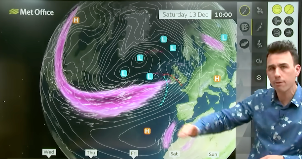
Met Office meteorologist Aidan McGivern explained how low pressure is swinging in another frontal system
|MET OFFICE
“Western parts of the UK are already saturated with rivers and water tables at breaking point, so we could be looking at a serious flooding issue in the run up to Christmas.”
With the wet and windy weather will come rising temperatures, with highs in the south hovering in double figures.
But despite hopes of festive flurries melting by the day, bookies are hopeful for that crucial flake on Santa’s sleigh.
Ladbrokes has cut the odds on a White Christmas to 1-2, although the hottest December on record is now at 3-1.
Spokesman Alex Apati said: "With temperatures dropping and a record-breaking cold December looking more likely, we wouldn't be surprised if there's a White Christmas on the cards this year."