


The Met Office has issued multiple rare amber weather alerts as a jet stream-fuelled Storm Bram prepares to smash into Britain.
From tonight, strong winds and heavy rain will lash the UK’s western coast, sparking multiple warnings over potential closures of roads and transport services.
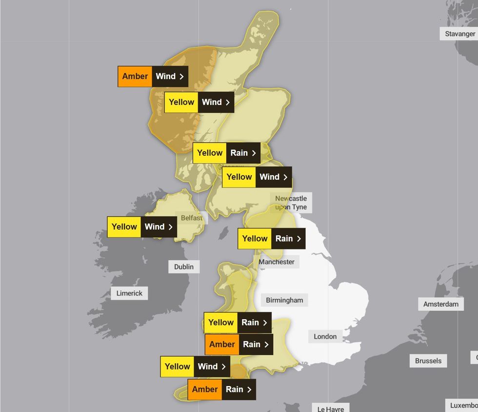
Two amber rain alerts will come into force across parts of South West England and Wales from midnight tonight and are scheduled to last until 10am on Tuesday.
A separate amber wind alert has been issued for northwestern Scotland, affecting Highlands & Eilean Siar, and Strathclyde from 4pm tomorrow until midnight.
TRENDING
Stories
Videos
Your Say
Half a dozen other yellow warnings are in force extending across all of Scotland, down Britain’s west coast as far as Land’s End in Cornwall and as far east as Portsmouth.
Britain’s national forecaster warned: “Storm Bram will bring a spell of very strong and disruptive winds to northwest Scotland on Tuesday night.”
“A short spell of very strong southwesterly winds are expected to develop as Storm Bram passes close to northwest Scotland on Tuesday evening and night.
“Gusts of 70-80 mph are expected for a few hours with a chance that a few places may experience gusts of up to 90 mph.
“Heavy rain will accompany these strong winds and may exacerbate impacts.”
Met Office alerts are in force across the country, including multiple amber alerts across the UK's west coast
|MET OFFICE
To prepare for the looming storm, Britons have been told to check for loose items outside homes and plan how to secure them.
Items including bins, garden furniture, trampolines, tents, sheds, and fences, could be blown away in the high-powered storm.
There is also likely to be disruption to travel with the forecaster urging Britons in affected areas to check bus and train timetables, and to amend travel plans if necessary.
It also urges that if driving, to check road conditions and ensure you have essentials in your car (warm clothing, food, water, a blanket, a torch, an in-car phone charger).
LATEST DEVELOPMENTS:
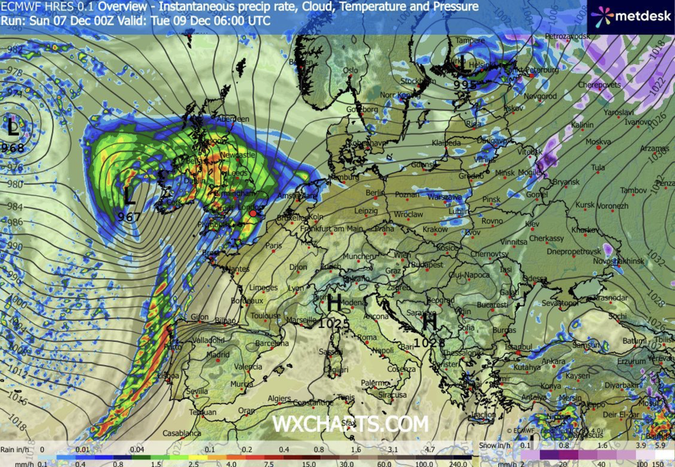
WX Charts map shows a Storm Bram hurtling towards Britain
| WX CHARTSThe Met Office continued: “If you are on the coast, stay safe during stormy weather by being aware of large waves, even from the shore, large breaking waves can sweep you off your feet and out to sea.
“Take care if walking near cliffs; know your route and keep dogs on a lead. In an emergency, call 999 and ask for the Coastguard.”
Yellow wind warnings in other parts of the UK will affect Grampian, Orkney & Shetland, Central, Tayside & Fife, North East England, North West England, SW Scotland, Lothian Borders, Wales, Northern Ireland, and South West England.
Yellow rain warnings will concurrently affect Central, Tayside & Fife, SW Scotland, Lothian Borders, Strathclyde, Yorkshire & Humber, North West England, North East England, South West England, Wales, and parts of the West Midlands.
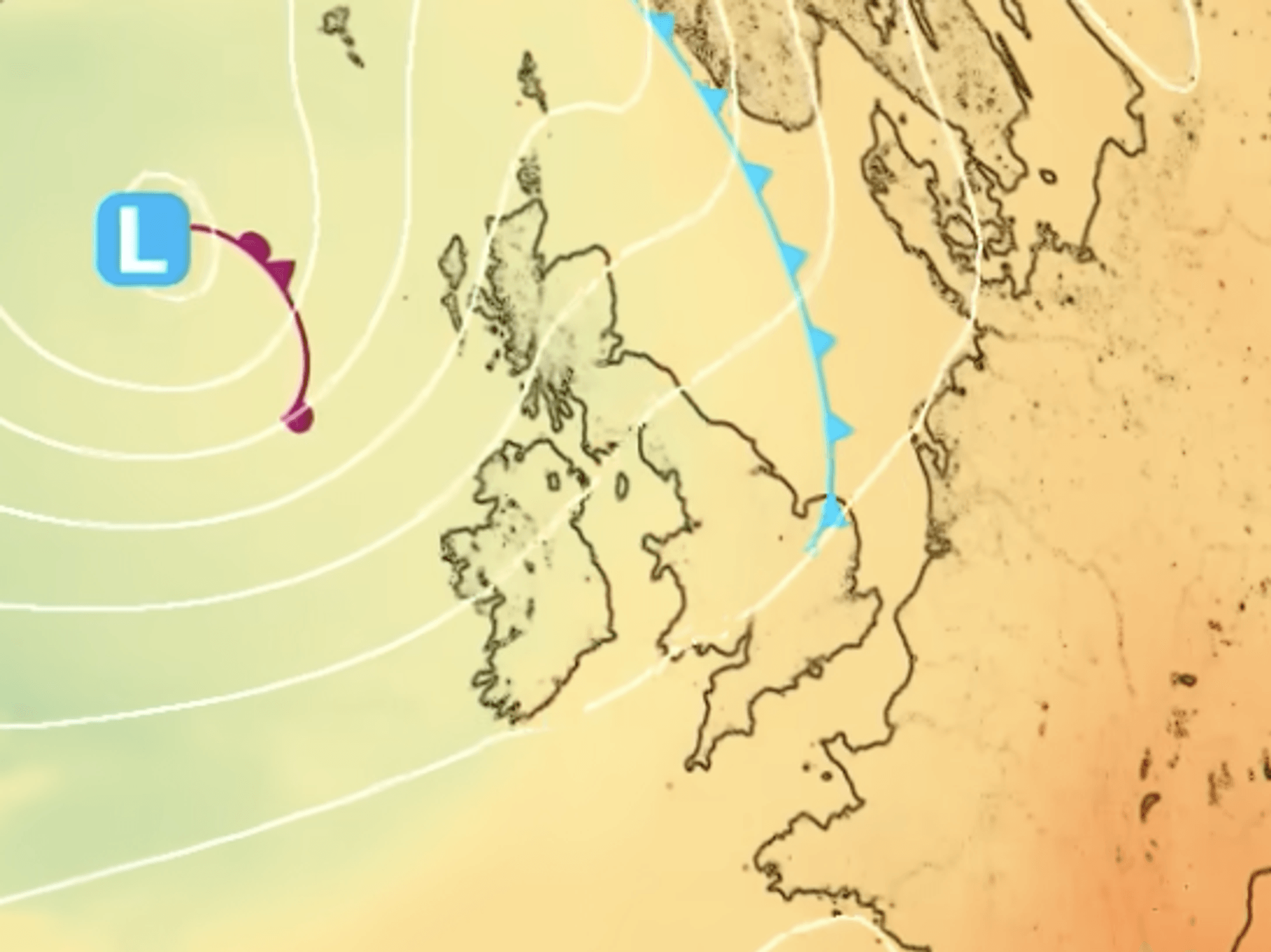
Met Office meteorologist Alex Burkill said: “As we go into Tuesday, there is an area of low pressure that is coming towards us and it looks like tracking across Ireland and northern Ireland and then Scotland.
“It could be particularly deep, and even some inland parts could see some windy and potentially damaging weather.
“We could also get some heavy rain, and with saturated ground, this could cause some issues.”
Our Standards: The GB News Editorial Charter