


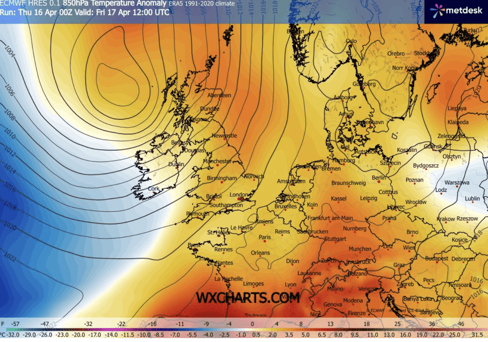
A pressure dome about to smother Britain will split the nation between summer-like sunshine and icy easterly winds.
Rain is off the agenda from this weekend, with temperatures under clear skies to rocket in parts to late-August highs.
But winds sweeping around a "dominating" lid of high pressure will plunge eastern coasts into foggy, autumnal mornings.
Met Office meteorologist Annie Shuttleworth said: “It is from Sunday that high pressure starts to dominate from the south, pushing northwards to dominate the whole country, and it looks like it will dominate through next week.
“In the sunshine, it is going to be pretty warm, with the strength of the sun is equal to late August at this time of year.
“Easterly winds, however, are not a particularly warm direction, so it is not going to be particularly warm out of the sunshine.
“Across the East Coast, we could see some sea fog bringing particularly cold mornings.”
High pressure will turn off the taps on heavy rain which is forecast to douse western regions ahead of the weekend.
Pressure dome smothering Britain will split nation between summer-like sunshine and icy winds
|WXCHARTS
Such ‘"anticyclonic" weather patterns are notoriously stubborn to shift, meaning dry weather will hold out into late April.
It will follow a wet and windy end to the week, with up to 60mph gales gearing up to batter northwestern coasts.
Ms Shuttleworth said: “On Friday, an area of low pressure pushes to the north of the UK, and it is going to be a pretty windy day to the north and the west, and a spell of wet weather will push through the country through the middle of the day.
"Parts of Northern Ireland and the far west of Scotland could see gusts up to 50mph, possibly 60mph, and it will be an unsettled day.
LATEST DEVELOPMENTS
“For most of us, there will be plenty of dry weather to come, and there is a good chance that it could last into next weekend.”
Temperatures for many will lift above average by the weekend, with highs of 20C possible in the south.
Jim Dale, meteorologist for British Weather Services and co-author of Surviving Extreme Weather, said: “It is going to feel pleasant going into the weekend, with a spell of what I would call proper spring weather on the way.
“High pressure is going to become dominant, meaning that apart from the far northwest of Scotland, there will be no rain.
“Temperatures are widely expected of 17C, 18C or 19C, with 20C possible in the southeast.”
However, sun-lovers should make the most of the warmth, with the end of April threatening something chillier.
Ms Shuttleworth said: “Beyond next week, the area of high pressure starts to move.
"And we could have more northerly winds pushing in, which means it could turn more unsettled but also more cold.”
Our Standards: The GB News Editorial Charter