


A rare "super El Nino" simmering in the tropical Pacific could be about to turn the burners up on Britain’s summer.
El Nino, which happens when waters around the coast of South America turn unusually warm, can have catastrophic global impacts.
While its effects in the UK are limited, it has been linked to hotter summers and colder winters.
Current forecasts from the US National Oceanic and Atmospheric Administration (NOAA) suggest a potential El Nino during the second half of 2026 could be one of the strongest ever recorded.
TRENDING
Stories
Videos
Your Say
If all the ingredients come together, Britain could feel the effects later in the season, according to long-range forecasters.
Jim Dale, meteorologist for British Weather Services, said: “Although this will take time to get going, it might make summer interesting in terms of temperatures.
“El Nino tends to increase the chance of hotter weather over Spain and the Continent, which means if we get a southerly airflow we will catch some of that.
“There is a good chance if this does come off as forecast, that we could be looking at some very hot temperatures this summer.”
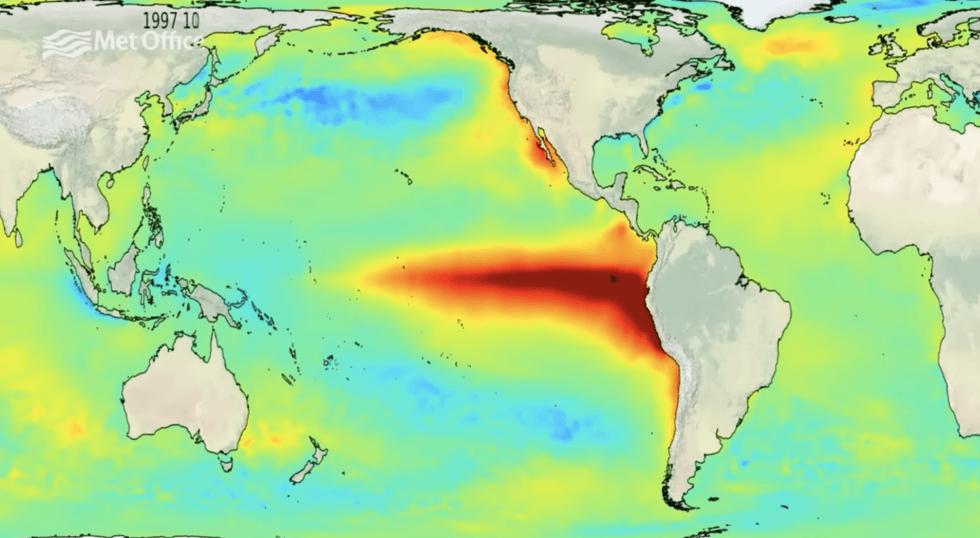
The phenomenon is triggered when winds across the Pacific slow or change direction, altering the water currents across the ocean
|MET OFFICE
The last El Nino happened in 2023, and led to changes in weather patterns, including monsoons, largely across the tropics.
The phenomenon is triggered when winds across the Pacific slow or change direction, altering the water currents across the ocean.
Warm water begins to accumulate around the Peruvian coast, leading to an increase in sea temperatures in the region.
While devastating local communities, such as hitting the fishing industry, it can jolt weather patterns around the world.
LATEST DEVELOPMENTS
In the UK, El Nino (ENSO) and its cooling counterpart, La Nina, have been linked to hotter summers and cooler than average winters.
Its greatest effects are seen at either end of the season, with colder weather more likely during January and February.
A Met Office spokesman said: “ENSO can impact the UK weather.
“The impacts of El Nino and La Nina on the UK are moderated by competing global climate drivers, however in general, La Nina increases the risk of a cold start and mild end to the winter.
“El Nino increases the risk of a windy and mild start and cold end to winter.”
Meteorologists are watching Pacific temperature forecasts with El Nino expected to be confirmed during summer.
David Dixon, meteorologist for Covering Climate Now, said: “An El Nino is expected to form by mid-summer.
“NOAA Climate scientists have also highlighted the real possibility that this upcoming event may be strong, to very strong, dependent on wave patterns in the Pacific through the summer months.
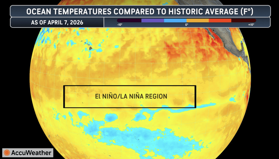
Ocean temperatures have increased in recent years
|ACCUWEATHER
“El Nino is one of the biggest shapers of year-to-year weather across most of the planet.”
Tom Di Liberto, media director for Climate Central, said: “We have much warmer than average water that is slowly making its way from west to east, and that is the reason why there is an El-Nino watch.
“The stronger an El Nino, the more consistent the impacts we see across the globe, and there is about a one-in-four chance of this being a very strong El Nino.”