


Britons will need to get T-shirts and shades ready for another blast of near-70F spring sunshine.
Temperatures over the coming days are forecast to climb as tropical winds sweep in from the south.
Tussling weather patterns will deliver a wet and windy run-up to the next warm spell, with northern and western Britain facing heavy downpours.
The second half of April, however, could bring a nationwide change as calming high pressure takes control.
TRENDING
Stories
Videos
Your Say
Jim Dale, meteorologist for British Weather Services, said: “We could see temperatures in parts by the weekend back up to 20C.
“It is going to be pretty decent as low pressure comes into the north and drags a plume of warmer air up from the south.
“We are also expecting high pressure to build in from the south, and that will bring clearer skies and sunshine.”
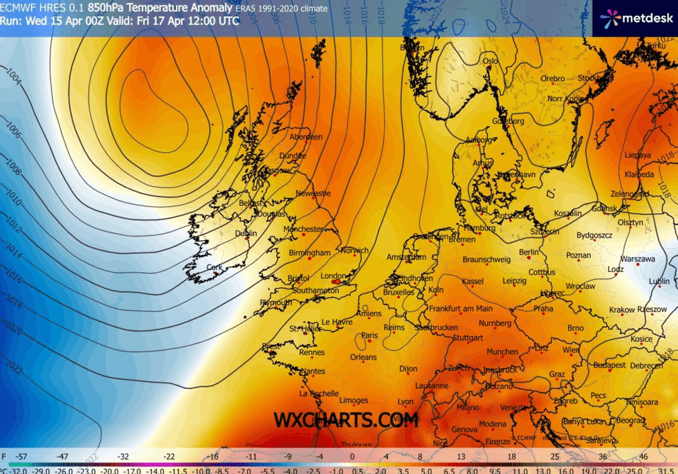
Temperatures over the coming days are forecast to climb as tropical winds sweep in from the south
|WXCHARTS
Britain’s weather is currently being driven by a ‘col’ of four competing weather systems straddling the country.
Low pressure to the north and south, and high pressure either side, has split the nation with rain to the north and clear skies to the south.
Stormy low-pressure cells from the Atlantic will continue to push into northern and western regions through the end of the week.
LATEST DEVELOPMENTS
But it is all expected to change by the weekend with warmer, sunnier weather possible through the end of the month.
A Met Office spokesman said: “As we head into Saturday, low pressure is expected to move away northwards, but showers may still affect western areas.
“There are, however, signals that a 'chunkier' area of high pressure may start to edge in and influence the weather later in the weekend.
“If that develops, conditions would become drier, brighter and more settled for more places, with Sunday offering the best chance of fine, dry and sunny weather.”
Thermometers will rise day to day, hitting the high teens in eastern counties by the end of the week.
To the west, stormier Atlantic blasts will bring heavy rain and the risk of strong winds to coastal areas.

Thermometers will rise day to day, hitting the high teens in eastern counties by the end of the week
|WXCHARTS
Met Office meteorologist Alex Deakin said: “Another low gains a bit of strength on Thursday night into Friday, and it is likely to bring a band of rain into the west and some fairly stiff winds.
“Temperatures in eastern England could get into the high teens, and for most places it is a fairly mild day.
“Then low pressure exits to the north, and an area of high pressure may just waddle in, and that would bring some fine, dry and sunny weather.
“And then, there is the potential for high pressure to nudge in as we get to the weekend.”