


An "erratic" weather front riding a wildly snaking Pacific jet stream threatens an 27C thunderstorm eruption.
Britain’s weather is about to be thrown to the mercy of a cluster of freakish weather patterns sending temperatures rocketing as the heavens open.
A storm in the Eastern Pacific jiggling the jet stream on its path across the Atlantic will cause it to fracture into a troublesome ‘cut-off’ feature.
This will "wander around" the UK in the run up to the weekend whipping up bouts of unsettled and potentially disruptive weather.
Met Office meteorologist Aidan McGivern said: “The jet stream is coming from the Pacific, where there is an area of low pressure deepening quite quickly, and that pulls the jet stream south, and forces a ripple in the jet that travels downstream.
“It allows the jet stream over Canada to move north, and it goes north into the Arctic and causes to dig down and propagate and a portion of it gets cut off into a cut-off upper low.
“These cut off lows can wander around aimlessly, and so there is uncertainty next week with the position crucial for determining the weather into next week.”
Britain’s weather through the coming days will pendulum swing from wet and windy, to unseasonably warm before temperatures once again plunge.
LATEST DEVELOPMENTS:
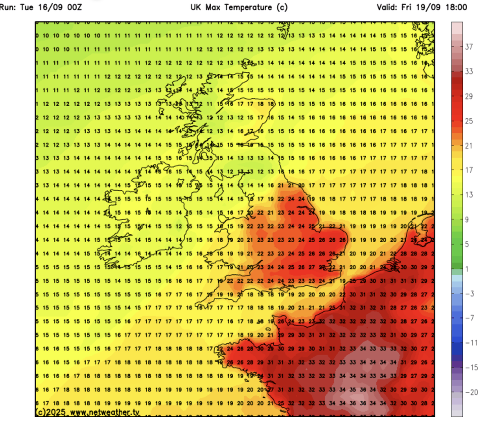
Friday will see the hottest temperature, with the mercury reaching as high as 27C
|NETWEATHER
Southern and southeastern Britain could hit a summer-like 27C over the coming days as a plume of tropical air sweeps in from the Continent.
However, bands of heavy rain will sweep across on a frenetic weather front sweeping the nation.
McGivern said: “As we go through the next few days, there are changes in the amplification of the jet stream, and it goes more wriggly over the North Atlantic.
“It brings up warmer weather to the southeast on Friday and into Saturday with the chance of Thunderstorms, and it pushes the wettest weather to the northwest of the UK.

Britain’s weather is currently heavily influenced by the track of the jet stream as it heads across the Atlantic
|MET OFFICE
“A weather front is going to wriggle erratically over the UK, and there is a zone of rain which turns increasingly heavy over the weekend as the cut-off low causes the air to rise and causes the rainfall to turn heavier.
“It will draw up warmth across the south and the southeast, and there is the possibility of 25C or 27C across the southeast.”
Britain’s weather is currently heavily influenced by the track of the jet stream as it heads across the Atlantic.
In a straighter west-to-east ‘zonal’ pattern, it pulls in stormy low-pressure systems bearing heavy rain and winds.
An expected switch to a wavy, north-to-south ‘meridional’ pattern will allow high pressure to build in its folds, although with the risk of spawning cut-off features.
High ocean temperatures after the hot summer are also, in part, driving the changeable weather.
This is likely to be the theme through the rest of the month as high pressure tussles low pressure.
Jim Dale, meteorologist for British Weather Services and co-author of ‘Surviving Extreme Weather’, said: “The sea temperatures are still high around the UK, and this puts energy into the system and causes instability in the atmosphere.
“This means we are going to be ebbing and flowing between these changes in weather patterns, and there is also the risk that when we get storms this autumn, they may be vigorous or more frequent.
“In the immediate forecast, low pressure will continue to bring unsettled weather in the run up to the weekend, but we are also going to see temperatures rise as warm air comes in from the Continent.”