
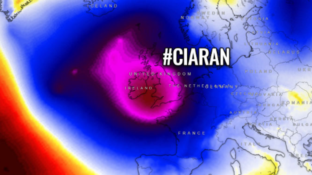


Britain will be battered by hurricane-force 90mph winds this week, as newly announced Storm Ciarán lashes the country.
On Thursday, Storm Ciarán will bring strong winds and heavy rain across the southern coast of England.
While UK waters technically aren't warm enough to support hurricane systems, a powerful extra-tropical cyclone - with hurricane strength winds - is forecast to hit southern Britain.
This is similar to what happened in the Great Storm of 1987, when powerful sustained hurricane-force gales of up to 86mph and gusts of more than 100mph.
The storm of '87 was caused by a cyclone that tore through Britain.
90mph winds are expected, with particularly significant waves likely to form along the coast.
According to experts at Severe Weather Europe, major storm Ciaran will blast the UK and Europe with violent hurricane force winds.
WATCH NOW: Today's weather forecast
Marko Korosec wrote: "The unusual weather pattern established over the North Atlantic and Europe over the last few weeks will continue and worsen as we head into November.
"The historically warm North Atlantic ocean water temperatures will support violent extratropical storm development towards Europe."
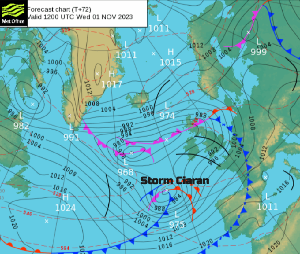
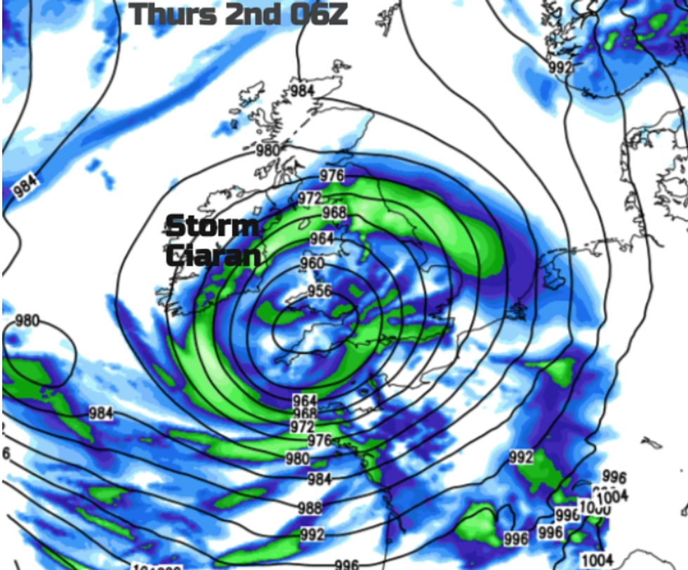
He added: "The first Atlantic storm Ciaran is coming up Thursday this week, with rapid cyclogenesis occurring before the major impact with violent, hurricane-force winds and heavy rain squalls blast into Ireland, the UK, the English Channel, northern France, and Benelux on Thursday."
Met Office Deputy Chief Meteorologist, Chris Almond, said: “Winds associated with Storm Ciarán are likely to gust to 80mph along the south coast of England, with a small risk of somewhere exposed seeing 90mph, and winds could even gust up to 50 or 60 mph further inland.
“This deep low-pressure system will also bring heavy rain to much of the UK, but the heaviest rain is expected in southern and western areas with 20 to 25mm quite widely across the region but up to 40 to 60mm potentially over higher ground.
“Heavy and persistent rain will fall onto already saturated ground bringing a risk of further impacts such as flooding in areas that are already struggling to clean up from the heavy rainfall we have seen over the last week or so.”
Flood warnings have been put in place across the UK.
Five different regions - East of England, London and South East England, South West England, Wales and the West Midlands - have been put under alert for fast-flowing water as a result of the heavy rainfall.
Areas impacted include Bath, Bristol, Cardiff, Cornwall, Devon Essex, Greater London, Herefordshire, the Isle of Wight, Hampshire, Kent, Newport, Oxfordshire, Plymouth, Southampton and Surrey.
The storm was officially named by the Met Office yesterday.
WEATHER LATEST:
The storm was named yesterday
|Met Office
On Thursday, two yellow warnings are in place in regions along the southern coast - one is for wind and the other is for rain.
The weather office said: "Heavy rain associated with Storm Ciarán is also likely to bring further disruption."
They warned of delays and cancellations to public transport.
Damages to buildings due to heavy flooding is also expected, which could cause "danger to life".
Hurricane-force winds are expected across parts of the UK
|Netweather
Flying debris as a result of the powerful winds could also endanger people.
The Met Office added: "There is a small chance that injuries and danger to life could occur from large waves and beach material being thrown onto sea fronts, coastal roads and properties."
Ahead of the arrival of Storm Ciarán, much of the UK is already facing wet weather conditions.
There are currently a number of weather warnings covering parts of the UK, with Wales and Scotland affected.
Persistent rain is continuing for north east England and much of Scotland with heavy bursts.
The severe weather conditions coincide with half-term at schools, meaning many travel plans for students could be negatively impacted.