


The Met Office has ramped up its weather warnings for the UK ahead of Storm Ciarán making landfall in a matter of days.
Yellow weather warnings for rain have been upgraded to amber by the national weather agency, with Britons warned "persistent heavy rain will lead to further flooding and transport disruption".
For Northern Ireland it says "extensive flooding of homes and businesses is possible" and that communities could be completely cut off "for several days".
The orange rain warning will last for 12 hours, coming into effect from 9.00pm tonight and lasting until 9.00am tomorrow.
WATCH NOW: Today's weather forcecast
It is place for parts of Northern Ireland, including County Antrim, County Armagh and County Down.
The weather office warnings come with a "danger to life alert".
It says: "Fast flowing or deep floodwater is possible, causing a danger to life".
The heavy downpour of rain could cause result in damages to buildings and homes.
WEATHER LATEST:
- UK HURRICANE warning: 90mph violent WINDSTORM Ciaran to smash Britain as heavy rain squalls spark hundreds of flood alerts
- UK weather warning: Storm Ciaran threatens to batter Britain with rain just days after flood hell
- Britain set to FREEZE as -20C Scandinavian ‘cold pool’ threatens to blanket UK in snow
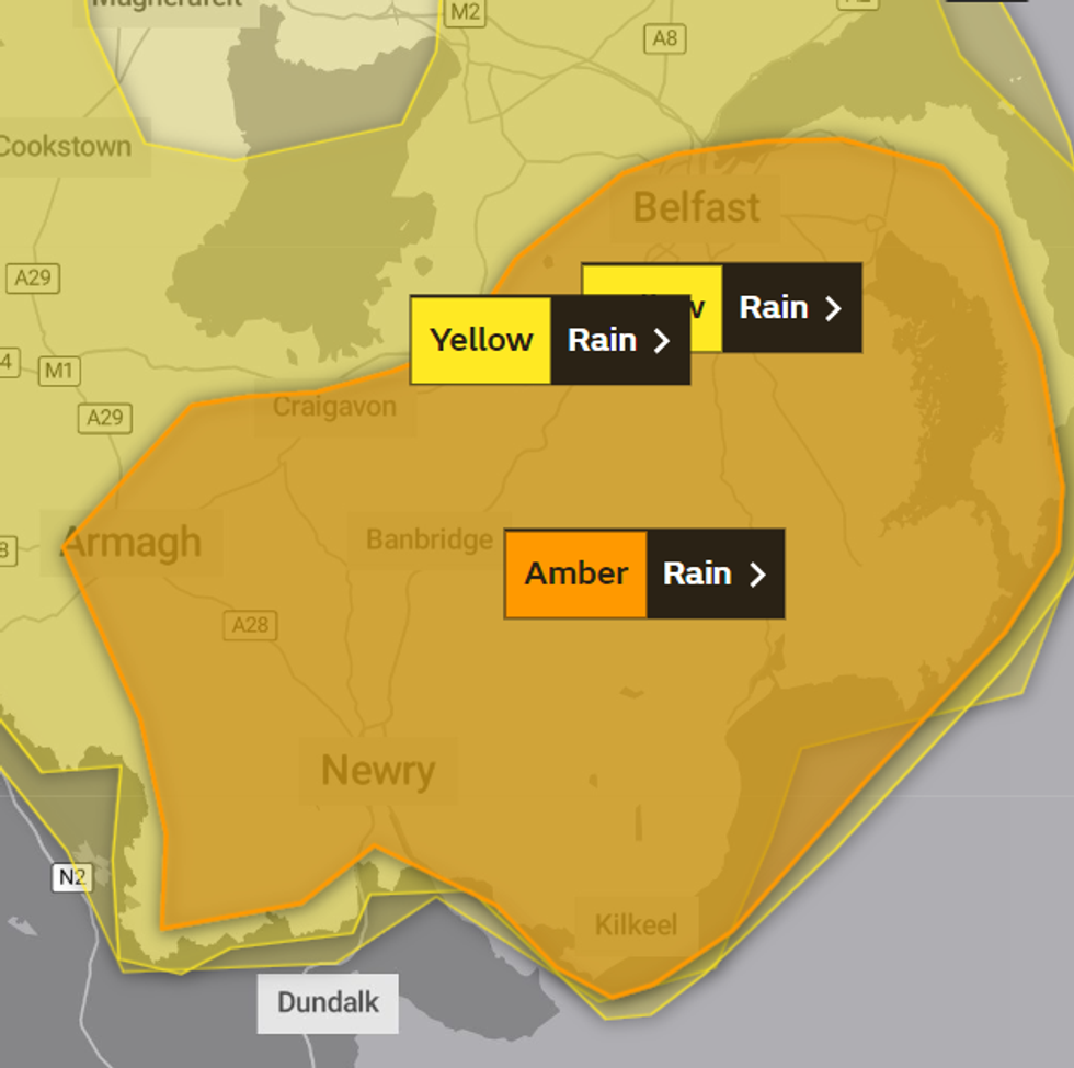
The amber rain warning is in place across parts of Northern Ireland
|Met Office
Damaged buildings may collapse, the weather office has cautioned.
The Met Office said: "Roads may potentially close, along with bus and train service delays and cancellations."
"Dangerous driving conditions might occur, because of spray and flooded roads," they continued.
The heavy downpours could also result in power losses, across a range of amenities, including gas, water and mobile phone services.
The floodwater could result in communities being completely cut off for days, the weather office has warned.
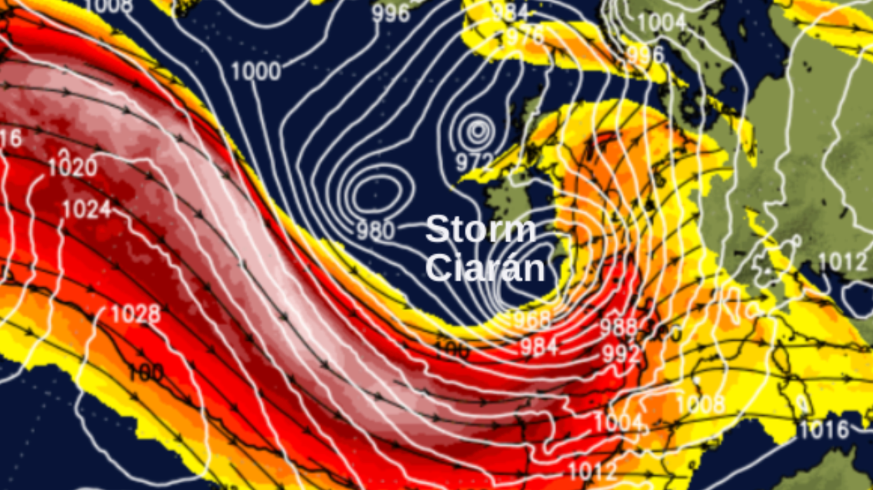
The upgraded warnings come just days before Storm Ciarán is set to batter the UK.
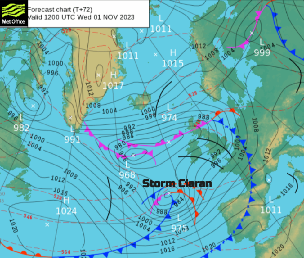
Storm Ciaran was named yesterday
| Met OfficeOn Thursday, Storm Ciarán will bring strong winds and heavy rain across the southern coast of England.
Hurricane-force gales are expected, with particularly significant waves likely to form along the coast.
Five different regions - East of England, London and South East England, South West England, Wales and the West Midlands - have been put under alert for fast-flowing water as a result of the heavy rainfall.
Met Office Deputy Chief Meteorologist, Chris Almond, said: “Winds associated with Storm Ciarán are likely to gust to 80mph along the south coast of England, with a small risk of somewhere exposed seeing 90mph, and winds could even gust up to 50 or 60 mph further inland."
"This deep low-pressure system will also bring heavy rain to much of the UK, but the heaviest rain is expected in southern and western areas with 20 to 25mm quite widely across the region but up to 40 to 60mm potentially over higher ground.
"Heavy and persistent rain will fall onto already saturated ground bringing a risk of further impacts such as flooding in areas that are already struggling to clean up from the heavy rainfall we have seen over the last week or so."