


A ‘severe storm’ flexing its muscles to tear through America threatens brutal winds, hail downpours and the risk of ‘snownadoes’.
Southern and north-western States are most at risk of the freak assault which could dump up to a foot of snow in parts.
Severe weather will persist through the week and into the weekend sparking warnings for travel chaos.
WATCH HERE: UK weather outlook
Weather Channel meteorologist Domenica Davis said: “We have a late week storm that is going to bring severe back into the picture.
“An area down to the south is where we could see those severe storms develop.
“Not only do we have that element, but the winter weather aspect of this storm, too.
“As we go through the weekend, there is the snow through the Rockies, moving to the east, and that rain-snow line starts to set up through the Central Plains and into parts of the Midwest, and that could develop some tricky travel throughout the weekend.”
US LATEST: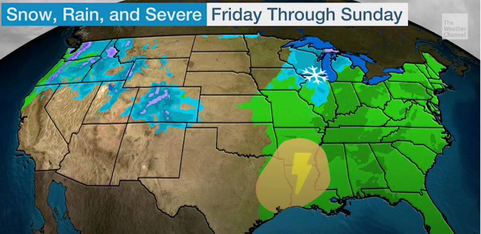
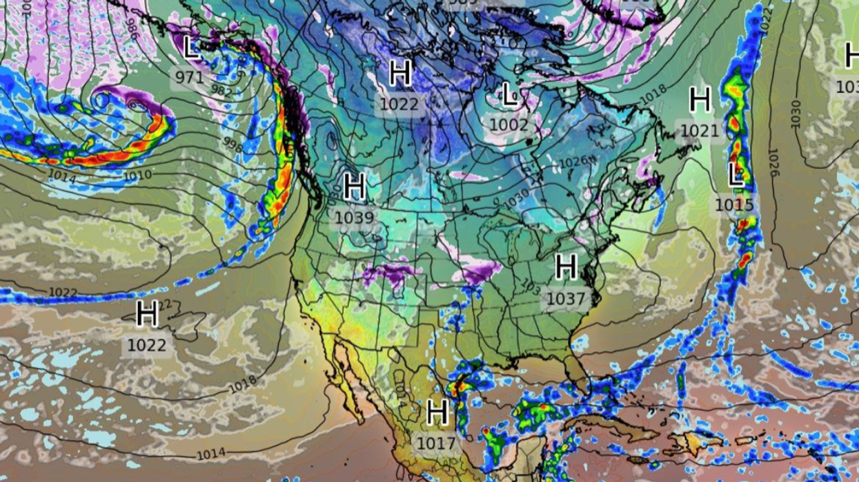
Warnings issued by The Weather Channel
|The Weather Channel
Volatile atmospheric conditions could drive see tornadoes whip up in parts of the country, according to the Weather Channel.
If temperatures drop in the same regions, spiralling columns of snow could add to the misery.
This could trigger the formation of a snownado, or ‘snow devil’–a rare phenomenon seen when snow is whipped up with a tornado.
In the northwest, ‘waves’ of heavy downpours driven by an atmospheric river threaten flash flooding.
Ms Davis said: “For the northwest the atmospheric river isn’t ending any time soon, and the flooding and heavy rain threat is going to continue through the rest of the week and even into the weekend.
“We are going to keep seeing these waves, not only are we looking at heavy rain on the coast, but we will have that snow pile up in the higher elevations further inland.
“Into the weekend, and the hits keep coming, we should get a break on Sunday, but until then, we are looking at a lot of rain.
“Snowfall-wise, we could be looking at a foot, or even more, in some parts.”
The US National Weather Service (NOAA) advised people in the Pacific Northwest to avoid travel during heavy rainfall.
It said warm air acting with the atmospheric river will bring ‘very high snow’ levels to parts mid-week.
A spokesman said: “A strong atmospheric river impacting the Pacific Northwest is expected to continue soaking the region with heavy rain through Wednesday.
“Warm air associated with the stream of moisture extending from the subtropical Pacific will continue to allow for very high snow levels through early Wednesday, which will exacerbate the flooding potential due to snowmelt and increased runoff.
“Flood Watches, Warnings, and Advisories have been issued for this part of the country. Residents are advised to never drive through flooded roadways and have a plan if within an area that typically floods.”
Jim Dale, social commentator and US weather correspondent, said: “It is wet and windy and in all, a bit of a mess.”