


Winter will take its first bite this weekend as a "Icelandic anticyclone" hits Britain with sub-zero tempretures.
Forecasters said a "big change" in the weather will swap mild temperatures with below-average lows.
While northern regions face the greatest risk of snow, flurries could sweep further south next week.
A high pressure "anticyclone" sweeping in from Greenland and Iceland will make parts of the country feel close to -12C.
Met Office meteorologist Alex Burkill said: “There is a big change in our weather through the next 10 days, because we are going to see something markedly colder and the risk of snow for many places.
“As we go through this weekend and next week, our air will come from a northerly direction, and this will see our temperatures dropping.
"High pressure is developing from the west, and this is going to dominate our weather through the latter part of the weekend and next week.”
Scotland and northern England will feel the first shiver as northerly winds push in from the Arctic.
Cold northerly winds are pushing in from the Arctic
|MET OFFICE
The rest of Britain will not be far behind, Mr Burkill warned, with wintery showers possible across southern regions.
He said: “High pressure drifts down from Greenland, and that is going to lead to a real change in our wind direction.
“Cold Arctic air will push its way southwards through the weekend and into next week with temperatures plummeting as Arctic air makes its way across the whole country.
“By Monday, with Arctic air plunging all the way across the country, temperatures are going to be several degrees below average, and this is going to mark a change after it has been so mild.”
LATEST DEVELOPMENTS
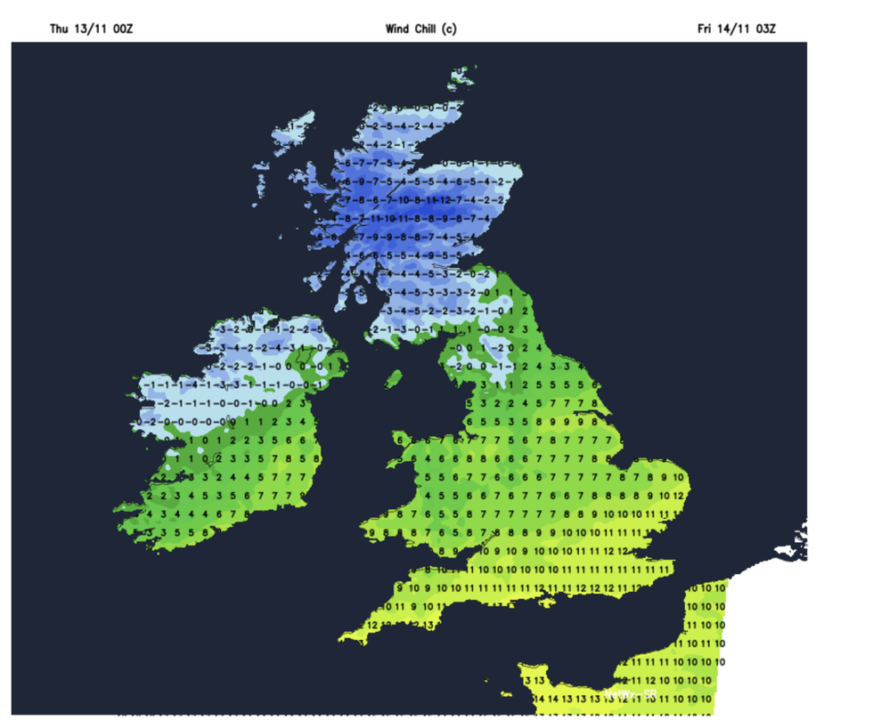
Weather models show temperatures across northern Britain nudging minus 10C
|NETWEATHER
Weather models for the middle of next week show temperatures across northern Britain nudging -10C.
“By Wednesday, a weather system could push its way southwards, some models have this coming from Iceland, and this would bring some rain, but on the northern side, it could bring some sleet and some snow across some parts,” Burkill said.
He added: “This is likely to feed south on Wednesday, and we could see some wintry weather pushing southwards.”
Next week shows high confidence of marking the coldest spell of the year since last winter.
As ‘real’ temperatures – those measured just above ground level – fall to -10C, feel-like temperatures could hit -12C.
Jim Dale, meteorologist for British Weather Services, said: “We are going to see a major change in the weather, and this is going to be the talking point as we go through the weekend and into next week. We are looking at temperatures in minus double figures and the first proper snow of the season. The most likely location for wintry showers is across high ground of Scotland, although there is a growing risk of flurries lower down.”
As temperatures nosedive, bookies are taking the axe to the odds on a White Christmas.
Coral’s John Hill said: “Temperatures are taking a nosedive next week, and that has prompted a rush of bets for a White Christmas this year. We have also slashed the odds on snow falling on any major UK city next week.”
Our Standards: The GB News Editorial Charter