


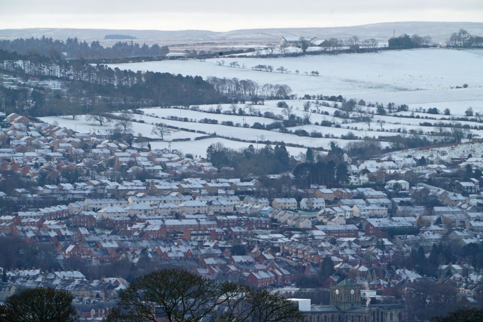
A bitter Arctic chill this weekend will bring an early taste of what experts fear may be a cold and harsh winter.
Meteorologists have sounded early alarm bells for shifts in the atmosphere driving sub-zero temperatures.
A Sudden Stratospheric Warming (SSW), the powerhouse behind 2018’s notorious Beast from the East, is a growing risk, forecasters warn.
Pressure fluctuations across the Atlantic, the so-called North Atlantic Oscillation (NAO), also hint at prolonged chill.
TRENDING
Stories
Videos
Your Say
In his European outlook, which covers the UK, Dr Todd Crawford, meteorologist for Atmospheric G2, said: “Climate models that handle SSWs and their impacts better are suggesting a relatively early SSW, with the biggest potential cold impacts in January.
“Even with another warm winter forecast from the models, there are some things that suggest we may have some significant colder volatility. In particular, we think there are very good odds for an SSW this year, which suggests colder risks later in the winter.”
An SSW would disrupt the Polar Vortex – the huge body of air that circulates over the North Pole.
When the Polar Vortex weakens, as during an SSW event, it can slip south over Europe and Britain.
A bitter Arctic chill this weekend will bring an early taste of winter
|NETWEATHER
Dr Crawford said: “The polar vortex is a large, cyclonic circulation of strong westerly winds that forms in the stratosphere over the poles each winter.
“A strong Stratospheric Polar Vortex during winter keeps cold air locked at Arctic latitudes, favouring mild winters in mid latitudes.
“Whereas a weak or disrupted vortex, often due to SSW, allows colder air to sink southwards leading to cold outbreaks, such as ‘the Beast from the East’ in Europe in February-March 2018.”
Experts have agreed on an "imminent disruption of the Polar Vortex" shooting the northern hemisphere with freezing waves of cold.
LATEST DEVELOPMENTS
Forecasters has provided a verdict on when snow and ice to return
| PAThe United States and Canada could be first in the firing line with the impact on Europe still under discussion.
Severe Weather Europe’s Andrej Flis said: “A significant disruption of the Polar Vortex is about to start, due to an unusually early Sudden Stratospheric Warming Event.
“The forecasts show a collapse of the polar circulation in the second half of the month, with cold weather and snow to follow across the United States and Canada, but with less clear impacts over Europe for now.”
Meanwhile, the UK is gearing up for a stormy end to the week before the mercury dips into winter lows.
The Scottish Highlands are braced for the first snow of the season with England to enter the freezer next week.
Jim Dale, meteorologist for British Weather Services, said: “After the weekend, there will be shift in the weather with things turning much colder and the risk of snow over the Highlands. This week, as low-pressure fronts come in from the west, the risk is rain, and with this will come the risk of flooding.”
Met Office chief forecaster Neil Armstrong added: “Low pressure is dominating our weather this week, with multiple warnings in force and more unsettled weather to come.
“We are keeping a close eye on already saturated ground as this could lead to some flooding. Difficult travelling conditions are also expected, with delays and the increased possibility of accidents.”
Our Standards: The GB News Editorial Charter