


Summer will blast back in an eruption of thunderstorms and spectacular "cloudscapes" as Britain braces for 30C heat.
Yet another colossal shift ahead of the weekend will send the mercury rocketing from below to above average.
After the record-smashing spring heatwave gave way to dull skies and chilly winds, the UK weather is once again poised to crank gears.
But the heat will arrive with a bang as pressure patterns collide to unleash summer storms and towering cloud formations.
Met Office meteorologist Alex Deakin said: “The showers and the cloud will soon start to bubble up on Wednesday, and there are some beautiful cloudscapes this week, and the showers are likely to be heavy and frequent across central and eastern England and Scotland, with hail and thunder possible.
“The pressure is slowly starting to build, and many places are much drier on Friday with a better chance of seeing some bright and sunny spells coming through, and the temperatures will be ticking up to 20C, so closer to average for the middle part of June.
“Warmer air will waft up with high pressure, and there are strong signals that this high pressure will bring drier and warmer weather as we head into the weekend, and it is slowly going to turn sunnier.”
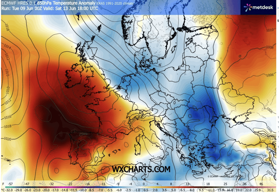
An Atlantic low-pressure system steered by a looping jet stream will fuel the mid-week storm eruption, Mr Deakin warned.
Summer will blast back in an eruption of thunderstorms and spectacular ‘cloudscapes’ as Britain braces for 30C heat
|WXCHARTS
He said: “Low pressure is the dominant feature, being controlled by the jet stream which is south shifted and in a U-shaped ‘trough’ not moving very far very quickly, allowing low pressure systems to generate thunderstorms and showers on Wednesday.
“Then high pressure is trying its best to edge up from the south by the end of the week. But before, there is plenty more rain.”
Temperatures under grey skies will hover around three to five degrees below average before rocketing at the weekend, he added.
He said: “Some of the rain on Thursday could be on the heavy side as it moves through, and probably not much sunshine with it staying pretty grey and cloudy for most of the day.
LATEST DEVELOPMENTS

Met Office meteorologist Alex Deakin said: “The showers and the cloud will soon start to bubble up on Wednesday'
|MET OFFICE
“Temperatures will generally be about three to five degrees below average for the time of the month.”
While a repeat of May’s record ending is unlikely for now, thermometers in June could nudge back into the 30s.
Jim Dale, meteorologist for British Weather Services and co-author of "Surviving Extreme Weather", said: “It is going to be a sea change to warm and then very warm.
“The change is likely after the middle of the week, with the weekend looking very warm in places. We could be back to 30C in parts of the country.”
Our Standards: The GB News Editorial Charter