


A "pressure cooker" of blazing sunshine, tumbling ‘foehn’ winds and simmering sea waters will push parts of the country into a record heatwave.
Britain is about to boil in the third blowtorch blast of summer with thermometers widely about to breach 30C.
Hot weather will hold out into next week in what is forecast to be the most widespread heatwave of summer.
Temperatures will rocket under the Azores High, pounding the air like a pressure cooker under the steer of the jet stream.
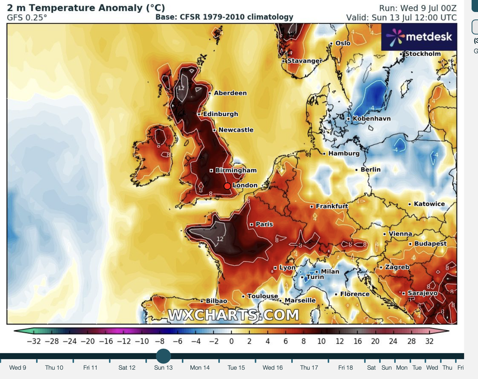
Temperatures could soar across Europe
|WXCHARTS
Adding to the sizzling mix will be unusually high sea temperatures and to the far north, gushing mountain winds.
Met Office meteorologist Alex Deakin said: “High pressure is building in from the southwest, squashing air and that is heating things up, and the sun is beating down, so temperatures are ticking up day by day.
“On Sunday, in the Moray Firth there is a higher chance of reaching over 30C and that is in part due to the foehn effect with the breeze coming in over the mountains and lifting the temperatures, and that would potentially push station records.
“The sea temperatures at the moment are anomalously high, and we are experiencing a marine heatwave with temperatures are well above average through the channel.”
 Cooler conditions are expected across the UK this weekend and into early next week | GETTY
The Azores High–a high-pressure system stretching from the tropical Azores Islands near Portugal–will settle across Britain through the coming days.
A frequent driver of summer heatwaves, it will build under the ‘warm side’ of the jet stream pushing temperatures to 30C-plus.
Hot weather will hold through the weekend and in parts into the middle of next week, Deakin warned.
He said: “The models are in really good agreement that we are going to see high pressure moving in and bringing hot weather for the vast majority into the weekend.
 |
| WXCHARTS
“We have been on the cooler side of the jet, that is why we have had some relief from the heat, but we are now merging onto the warmer side of the jet.
“Although it may turn a little cooler as we go into next week, the warm air may stay close by and temperatures could easily stay in the mid- to high-20Cs.”
Feeding into Britain’s warm weather is a freak marine heatwave driven by higher-than-normal ocean temperatures.
Southern coastal waters are around 1.5C warmer than average, with sea surface temperatures of 14.6C more typical of August, according to the Met Office.
 Some parts of England could reach up to 40C | PA
A spokesman said: “The south of the UK is currently experiencing a significant marine heatwave (MHW), with sea surface temperatures in the Celtic Sea, English Channel, and Southern North Sea registering anomalies of 1.5C to 3C above the 1982-2012 average.
“These conditions, classified as moderate to strong marine heatwaves, are expected to persist and intensify, particularly in the Celtic Sea and western English Channel, over the coming week.”
Warm ocean temperatures will help drive hot weather this summer, with even hotter weather likely through the last third of the season.
Jim Dale, meteorologist for British Weather Services and co-author of ‘Surviving Extreme Weather’, said: “Higher-than-average sea temperatures after hot weather through spring and the start of summer will help drive further hot weather through the rest of summer.
“We could see temperatures in the high-30Cs or even above through the latter part of this month.”