


A Polar-heatwave clash hurling a powerful jet stream out of America will lash Britain with a week of stormy weather.
Huge temperature contrasts across the United States, fuelling ferocious jet winds that will send cyclonic storms hurtling across the Atlantic.
Low pressure, the driver of unsettled weather, will dominate the weather through the coming week, experts warn.
Western regions face the brunt of the autumnal blast as the doors fling open to the Atlantic.
Met Office meteorologist Honor Criswick said: “On Monday, we have an area of low pressure swirling to the west of us, and this continues through the early part of next week.
“This is being fuelled by a strong jet stream, really adding to these areas of low pressure skirting in from the west.
“Next week looks changeable with spells of rain, some showers and potentially some strong winds.”
Low pressure will be steered towards Britain by the jet stream – a rapid ribbon of air high in the atmosphere circling the northern hemisphere.
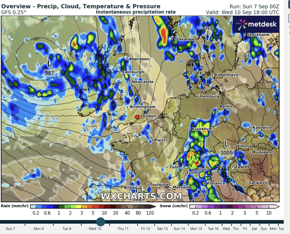
WXCHARTS has warned Britons could face a washout on Wednesday
|WXCHARTS
The jet is powered by temperature contrasts aloft, particularly over North America where temperatures to the north are in freefall while hitting the 80Fs further south.
A strong jet stream helps steer low pressure storm systems towards Britain, strengthening them en route.
Jim Dale, meteorologist for British Weather Services and co-author of ‘Surviving Extreme Weather’, said: “The jet stream is driven by cooler air moving into warmer air, and we are seeing this over the United States, which is usual for this time of year.
“However, that will send a strong jet across the Atlantic, and this will help drive unsettled weather towards Britain.
LATEST WEATHER STORIES:“For the next few days, there will be some considerable rain some of which could be heavy, and that will bring the risk of flooding to parts.”
Eastern Britain will get off lightly, he explained, with a nationwide split brining the worst of the weather to the west.
He said: “The main risk is going to be across the west of the country, while in the east it is going to be relatively quiet.”
An Atlantic low-pressure regime will kick off an unsettled start to the week, triggering five days of rain.

Netweather shows strong jet streams crossing the Atlantic
|NETWEATHER
Met Office meteorologist Alex Burkill said: “We are heavily under the influence of a low-pressure centre, and it is going to be at its deepest as we go into Monday, so there is some very unsettled weather to start the working week, and that is the theme through the week.
“The most likely set up has low pressure to the northwest, and as we go towards Wednesday, it is most likely that the low pressure is a bit closer towards us, so a wetter day, and it is a similar story on Thursday and Friday.”
A muggy weekend will see eastern fringes through the start of the week cling to 20C-plus temperatures.
Western and northern Britain will feel cooler as the mercury falls in chilly Atlantic winds.
A Met Office spokesman said: “It will remain unsettled with showers and longer spells of rain possible at times for all regions.
“It will be generally wettest in the west, and often breezy, with temperatures trending down a little bit.”