
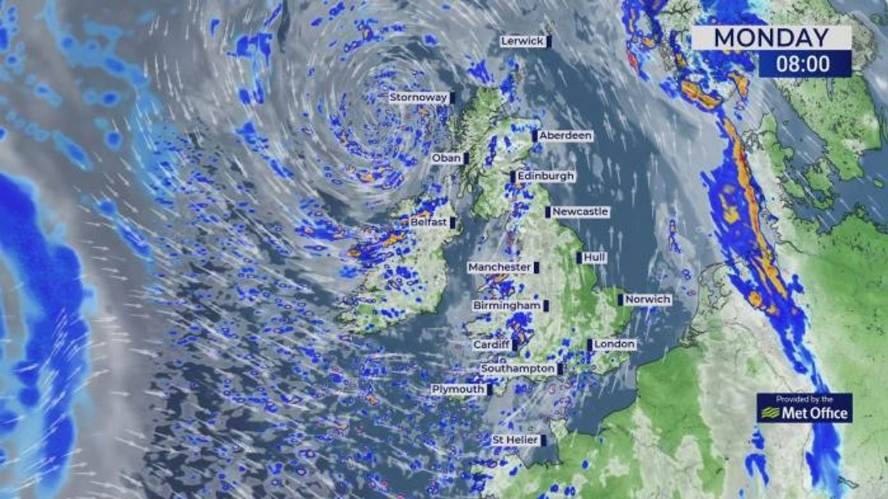


Polar winds blowing from the north Atlantic will drench Britain in the wettest spell of weather since before summer.
Torrential downpours will "pile in" this week as autumn’s arrival is rattled by cyclonic weather systems.
After months of minimal rainfall, relentless rain and gusty wind will batter swathes of the country.
Although unsettled weather will arrive on the tail of northerly winds, temperatures will hover close to average.
Polar winds blowing from the north Atlantic will drench Britain in the wettest spell of weather since before summer
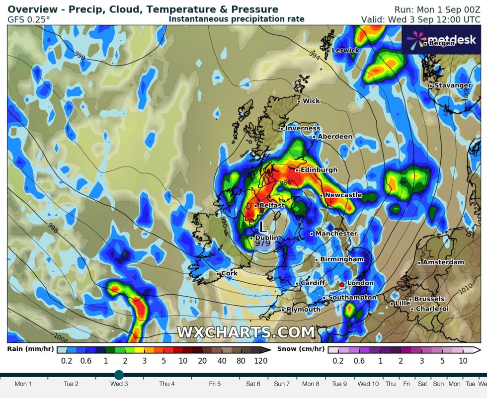
|WXCHARTS
Met Office meteorologist Alex Burkill said: “We end up in a Polar maritime air mass with showers coming in from the northwest.
“Western parts are bearing the brunt of the heaviest rain, whereas towards the east and the southeast, there is a greater chance of staying dry.
“There is a bit of a ridge of high pressure and so a bit of a lull into Tuesday, before more unsettled weather comes as various low-pressure systems and frontal systems make their way in from the Atlantic.
“It does look like they are going to pile in from the west and we are going to have some further spells of unsettled weather.”
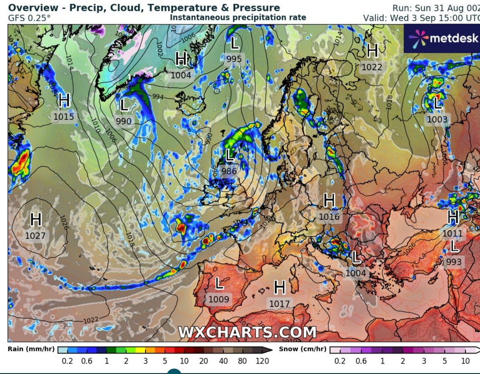
The change in weather will be driven by high pressure, dominant through summer, giving way to low pressure.
The drier-than-average summer will give way to a wetter-than-average start to autumn, Burkill warned.
He said: “It is more likely that we see lower-than-average pressure for the week, and that goes in line with that unsettled theme as we are expecting as we go into the start of meteorological autumn.
“Rainfall anomaly models suggest that it is going to be wetter than average, a very different story than we have been used to over summer, and western areas look significantly wetter than average, and even in the east it does look a bit wetter than average.”
After months of minimal rainfall, relentless rain and gusty wind will batter swathes of the country
|WXCHARTS
The change will come after an unusually dry spell which kicked off with one of the driest springs on record.
England parched in its driest spring for more than 100 years, according to the Met Office, while Wales saw its sixth.
Parts of the country this week could see the most rainfall for months, with no let up for more than a week.
Jim Dale, meteorologist for British Weather Services and co-author of ‘Surviving Extreme Weather’, said: “The weather is trending towards the wettest spell we have seen for a while, at least for the next 10 days.
“Western regions will see heavy and persistent rain, and this comes after weeks of very dry weather.
“In the east, however, it is a different story as here will be quite dry and sunny at times.”
Turbulent weather arrives just as the Met Office has released its league of autumn storm names.
Amy will be the first to strike this season, followed by Bram, Chandra, Dave, Eddie and Fionnuala.
Names have been submitted by weather watchers across Britain in a bid to raise the alarm when there is a risk of dangerous weather.
Met Office chief meteorologist Rebekah Hicks said: “Naming storms isn’t just about giving them a label, it’s about making sure people take notice.
“When a storm has a name, it becomes easier for the media and public to talk about it, share information, and prepare.
“It’s a simple step that can make a big difference in helping communities stay safe, protect their homes, and make informed decisions ahead of severe weather.”