


A "battleground" between a "Scandinavian anticyclone" and rain-laden storm fronts is about to deluge parts of Britain.
The UK will become a nation divided this week, with heavy rain and winds forecast for Scotland and the north and sunshine for the south.
The topsy-turvy outlook will be driven by the Scandinavian High – a region of anticyclonic high pressure wedged over northern Europe – and the last dregs of the Atlantic storm season.
Met Office meteorologist Honor Criswick said: “We could have high pressure sat out to the east, and this is a Scandinavian high.
TRENDING
Stories
Videos
Your Say
“There will be a real battleground between the northwest and the central south and southeast.
“The northwest will often catch the wet and windy spell as weather fronts push in and bump up against high pressure, so they often push northwards and don’t push south-eastwards.”
A chilly start to the week, which will bring some showers to southern regions, will give way to above-average temperatures, she added.
She continued: “On Tuesday, there are some heavy showers pushing into the south, and elsewhere there will be sunshine and showers.
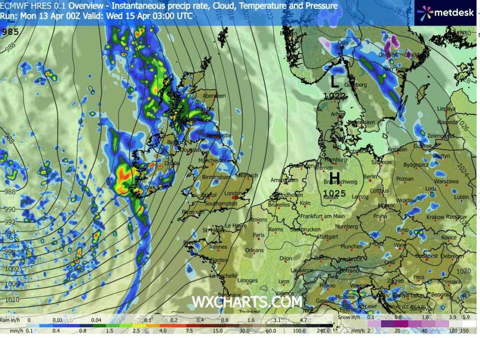
The UK will become a nation divided this week, with heavy rain and winds forecast for Scotland and the north and sunshine for the south
|WXCHARTS
“The warm spell was only a brief one, but as we head further into April, there is the chance we could see something a little bit warmer.”
While spring gets going across much of the country, Scotland and the northwest face a drearier picture.
Heavy rain pushing in from the Atlantic will hold out through much of the week, experts warn.
Southern regions will escape with sunshine and showers before temperatures rise mid-week.
LATEST DEVELOPMENTS
Jim Dale, meteorologist for British Weather Services and co-author of ‘Surviving Extreme Weather’, said: “Scotland and the northwest will get the rainfall this week, and it is going to hang around.
“To the southeast, it will be drier, though not completely settled.
“In terms of temperatures, it is turning warmer, but there will be a couple of days this week when there is still the risk of a little bit of frost.”
Met Office meteorologist Greg Dewhurst added: “At the start of this week, low pressure moves out of the way, ahead of another area of low pressure bringing some rain on Tuesday.
“Slowly through the day, bands of cloud and showery rain push eastwards, and temperatures are rising a little higher as we import some warmer air.
“Through the rest of the week, it remains changeable with showers and longer spells of rain, and temperatures are generally above average.”
Britain’s weather this year has been dominated by competing pressure patterns, yo-yoing between storms and hot spells.
High pressure is expected to take a greater role further into spring, bringing a calmer entry to summer.
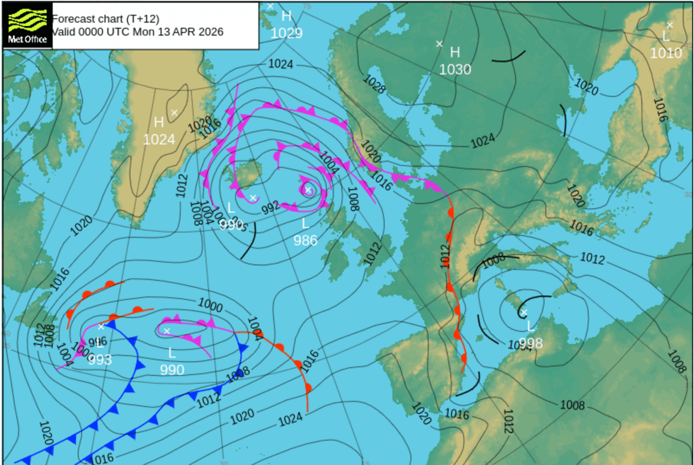
High pressure is expected to take a greater role further into spring, bringing a calmer entry to summer
|MET OFFICE
Met Office meteorologist Annie Shuttleworth said: “The most likely pressure pattern is for low pressure to sit to the north but high pressure dominating to the south and the east of the UK, and that will likely pull in drier and slightly warmer weather.
“However, up to the northwest is where we are more likely to see wetter and cooler weather.
“During the last week of April, the pressure pattern changes and high pressure becomes more dominant towards the north of the UK, and across the vast majority of the UK we have high pressure dominating so we could see prolonged dry weather.”