


Britain’s first summer scorcher could be just a fortnight away with a roasting 30C blast at the end of April promising to set the nation ablaze.
Sun-lovers are on notice to get T-shirts ready and barbecues fired up for a mid-spring mini-heatwave.
Thermometers will rise through the coming days, with a ‘pleasantly warm’ Easter weekend on the cards for many.
Surging African winds then threaten to push the mercury to boiling point before summer dishes up some ‘serious heat’.
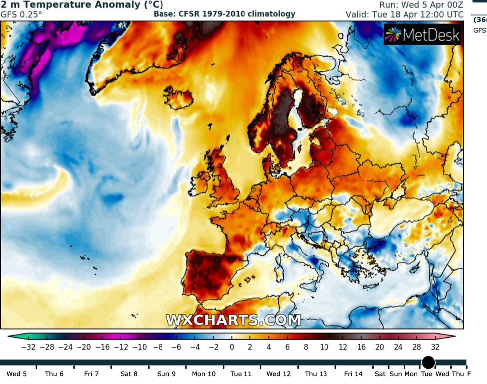
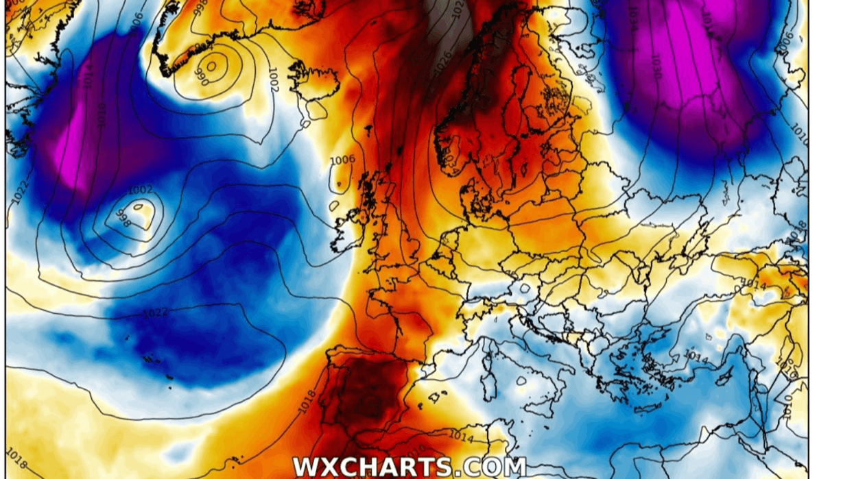
Heat from the Continent reaches the UK
|WX Charts
James Madden, forecaster for Exacta Weather, said: “It is starting to look good for later in April and into May when we could see temperatures reaching into the high-20Cs or even 30C in some spots.
“During summer, we expect an influence from the Azores High and African plumes dragging air up from the south, bringing some very warm weather.
“This could drive two to four very hot periods through summer, with the greatest chance during mid-June and mid-July.
“It is important to note that with this heat, there could be some periods of very humid, muggy weather with stubborn cloud cover, but this will need to be looked at closer to the time.”
In the meantime, Britons can look forward to a warm and pleasant Easter under clear, sunny skies.
Madden said: “We are not looking at a scorching Easter, unfortunately, but it will be settled with sunny spells.
“However, there will be some chilly evenings and mornings with the increased risk of showers as we go through the end of the weekend.”
Britons heading out in the sun should make the most of the first three days of the long weekend, experts say.
Friday, Saturday and Sunday could see temperatures nudge 20C in the sunshine, while Monday promises cooler temperatures and showers.
Jim Dale, meteorologist for British Weather Services, said: “We are looking at three days of reasonable, temperate, British weather, and while temperatures could reach 17C in some spots by Sunday, there will be chilly mornings.
“If people are heading out and about, they should probably avoid Monday as we expect to see a breakdown in the weather bring a wetter, cooler picture.
“Then, as we head into mid-month, we are looking at temperatures largely heading upwards, again with some cooler interludes, before it gets going by the end of the month.”
Late April could see the nation plunged into ‘sunburn weather’ as a plume of warm air wafts in from the Continent, he said.
As summer approaches, Britons should brace for ‘serious heat’ as the temperature rise accelerates, he added.
He said: “I would fully expect there to be some spikes of heat during the coming months.
“In terms of whether we will see a repeat of last year’s 40C-plus temperatures, the climate changes behind this have not changed, and while there could be some unsettled weather during the period, I expect to see some serious heat in the mix.
“Last year was an anomaly, and I would think the odds are against another 40C, but it is something we will have to watch over the coming months.
“But it will accelerate during the second half of April, and then we are into sunburn season.”
Bookies are getting in on the act, with Coral slashing the odds from 6-4 to 3-1 on records boiling over this month.
Spokesman John Hill said: “We are set for a pleasant Easter weekend, and although temperatures are unlikely to break any records over the bank holiday weekend.
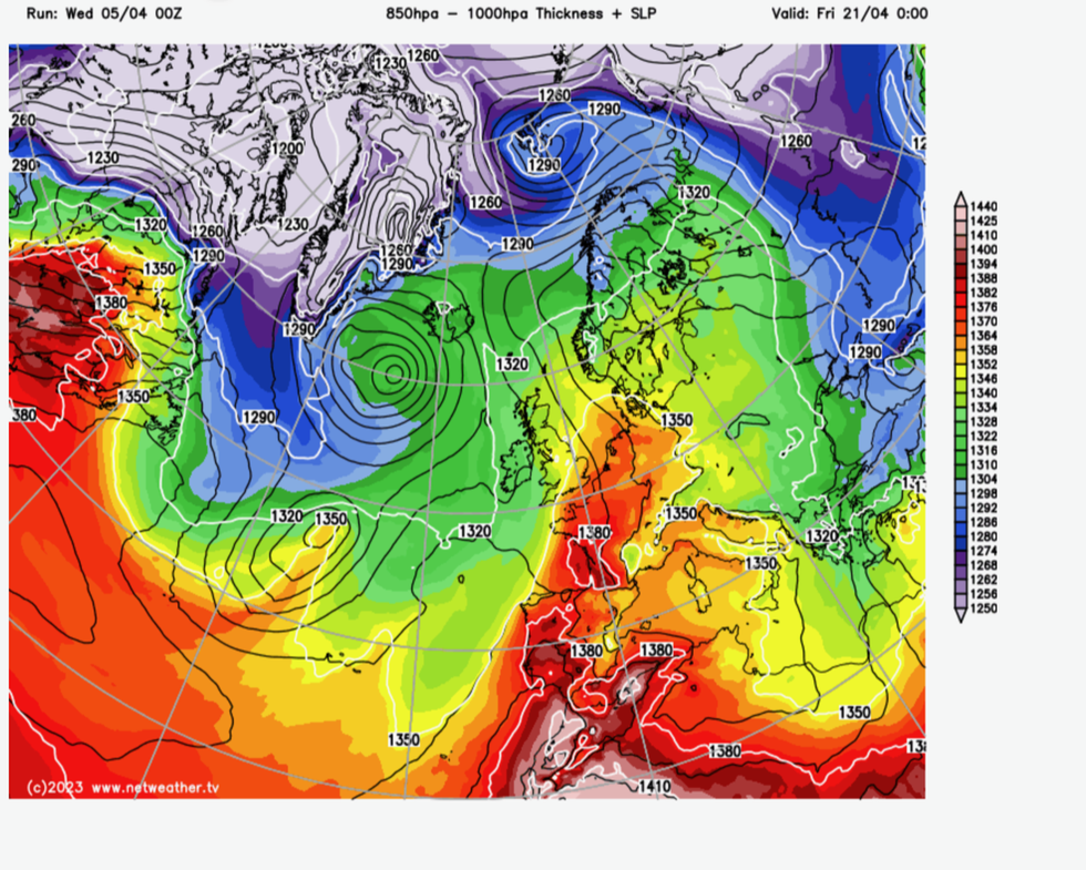
Weather charts show first signs of African plume
|Netweather
“If they continue to rise over the next couple of weeks, we could be set for the hottest April of all time.”
Scotland could be in for the best of the weather during the coming days, with eastern regions feeling cooler, according to the Met Office.
High pressure will keep things settled through the first three days of the holiday before the threat of more unsettled conditions.
Met Office meteorologist Aidan McGivern said: “Our weather is really going to slow down this Easter weekend.
“We have one area of low pressure to the west and one area of high pressure to the east, and that high pressure will bring easterly breezes to the east and the low pressure will bring south-westerlies into the northwest.
“For much of the UK, it is high pressure dominating things until we get to Monday.
“Things are looking very different from March.”