


Britons hoping for some more warm sunshine will soon be disappointed, as the UK is about to feel a sharp temperature plunge and feel “much cooler”, the Met Office has said.
The weather office has declared that the recent spell of balmy weather with unseasonably high temperatures is officially over, with the mercury soon set to drop around the country.
On May 1, the month kicked off to a glorious start, with highs of 28C recorded in south west London.
It marked the hottest start to May on record, but just a few days later, the mercury will take a dramatic turn.
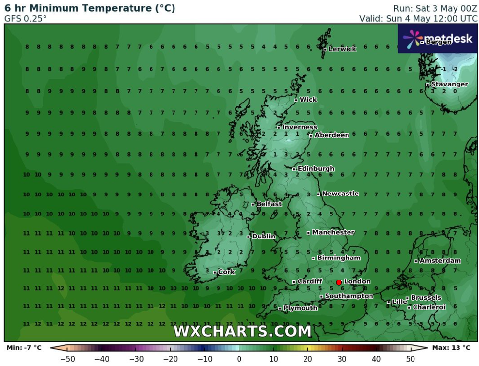
On May 4, high temperatures will 'subside' and be replaced with 'cooler weather' across the UK
|WXCharts
On May 4, high temperatures will “subside” and be replaced with “cooler weather” across the UK.
Met Office meteorologist Honor Criswick explains: “The main theme over the next few days is that it's going to be feeling much cooler [...] particularly across central and eastern areas, and some locations could see a good 10C difference if you compare the temperatures to 24 hours earlier.”
She added: “There is going to be more clouds across Scotland, some showers feeding through across the very north”.
Meanwhile, the southwest will see clouds and showers rising from the south, which could "turn quite heavy, particularly through the course of the day”.
WEATHER LATEST:
She added that “there's a chance they could turn thundery”.
Met Office Deputy Chief Meteorologist Tony Wisson explained: “The recent very warm weather for the time of year is subsiding over the weekend as a weak cold front moves over the UK. We expect cooler temperatures as the front pushes south.
“This cooler air will also help introduce isolated showers across eastern parts, but it should stay drier further west.
“Sunday will feel much cooler compared to recent days, with temperatures falling slightly below average for the time of year. We can expect mid-to-low double figures for many, and even single figures for those further north.”
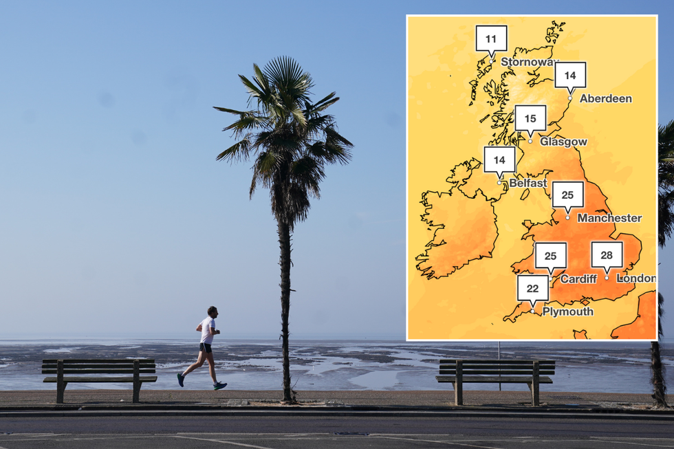
The Met Office has confirmed May 1 is the hottest start to May on record
| PA/Met OfficeWisson said that the coldest temperatures will be felt on Sunday and Monday, with a slight increase beginning on Tuesday - though nowhere near as high as recent days.
“High pressure will continue to dominate the UK weather next week, bringing largely dry weather and variable cloud amounts,” he said.
Thursday’s heat surpassed the previous May Day record of 27.4C, which was recorded at Lossiemouth, Moray, on May 1, 1990.
The high temperatures are particularly remarkable when compared to last summer, which wasn't even close to being this hot.
Last year's summer saw average temperatures of only 14C, making today's May heatwave all the more extraordinary.