


Bitter winds from the Arctic will plunge parts of northern Britain into the coldest day of spring with sub-zero temperatures, frost and snow.
Scotland and northern England will get the first bite of winter’s brief return before the whole UK is back in jumpers and coats tomorrow.
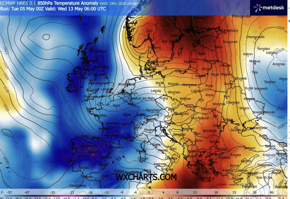
A sharp U-turn in the weather today will bring northerly winds across the country, pushing the mercury in parts to -5C.
Gardeners and farmers are warned to prepare for "damaging frosts" as showers over high ground turn to snow.
Met Office meteorologist Tom Morgan said: “Gardeners and growers should stay alert to the forecast over the next few days because we have some chilly nights, partly due to winds switching to a northerly direction on Tuesday and Wednesday brining in colder air from the Arctic.
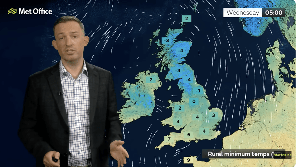
“On Wednesday, in more northern parts of the UK, minus 4C or minus 5C is possible in some prone rural spots, so there could be some damaging frosts.
“It will be a cooler, chillier day for all, and temperatures are going to be some 5C or 6C below average for the middle part of May.
“Showers blowing in on that northerly breeze are falling as snow across the Highlands and Grampians, so there is a bit of a wintry feel here.”
Winds will plunge Britain into the coldest day of spring
|WXCHARTS
The cold snaps follow an unusually mild start to spring with above-average temperatures so far this spring.
Highs pushing the mid-20Cs pushed March into near-record territory, making it the tenth warmest for more than a century.
Southerly winds helped nudge the mercury as the jet stream pushed northwards, allowing high pressure to dominate.
This week’s change will bring gusts down from the North Pole, although the cold snap should be brief, Mr Morgan explained.
LATEST DEVELOPMENTS
Gardeners and farmers are warned to prepare for ‘damaging frosts’
|MET OFFICE
He said: “It will be the coldest day of the week on Wednesday.
“Thursday will be a windier day for the northwest of the UK, but elsewhere it is a largely dry day with the odd isolated shower mostly in the west, and temperatures are back up to 14C or 15C in the south, although still no better than 9C or 10C across the very far north of Scotland.”
Rising temperatures will arrive with showers ahead of a wet and potentially windy weekend.
Low pressure over the Continent will push cold gusts back towards the Arctic while pulling in showers.
Jim Dale, meteorologist for British Weather Services and co-author of Surviving Extreme Weather, said: “We are seeing something showery and the rain song to be the main feature as we end the week.
“This is going to be most prominent across parts of Wales and western Britain, and some of this could be accumulating rainfall.”
Our Standards: The GB News Editorial Charter