


Britain could be weeks away from the first 30C-plus heatwave as forecasters predict a three-month summer sizzler.
As the nation shivers in a late-spring cold snap, meteorologists predict a season of unusually high temperatures.
They blame climate change and the risk of a ‘super El-Nino’ warming of the Pacific Ocean.
The Met Office’s three-month outlook predicts a 40 per cent chance of a ‘hot’ summer – double the normal odds.
Independent forecasters agree this year may push temperature records with another 40C ‘entirely possible’.
Jim Dale, meteorologist for British Weather Services, said: “I would expect that by the time we get to July and August, we could be back in the territory where there is a fair chance of seeing another 40C.
“If there is a heatwave over Spain and the Continent, all it would need is a push northwards for us to tap into these very high temperatures, and it is entirely possible we could reach or hit the record.
“This is going to make things very interesting as we go through summer, particularly when it comes to heat and humidity.”
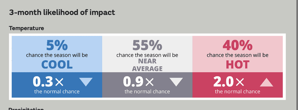
The Met Office’s latest three-month outlook predicts a 40-per-cent likelihood of ‘hot’ weather lasting into July
|MET OFFICE
The Met Office’s latest three-month outlook predicts a 40-per-cent likelihood of ‘hot’ weather lasting into July.
The driver, it says, is global warming, although other meteorological factors such as El Nino may contribute.
A Met Office spokesperson said: “Consistent with our warming climate, the next three months are more likely to be warm than cool.
“An increased chance of warm conditions implies a greater-than-normal chance of heatwaves, similar to that in recent years.
LATEST DEVELOPMENTS:
“Drivers of the UK weather for May to July include El Nino, which is likely to develop during early summer, and at this time of year, the effect is small but it does increase the chances of unsettled weather.”
Meteorologists have begun to sound the alarms for a growing threat through the coming months of a ‘super El Nino’.
El Nino events happen every two to three years when sea surface temperatures in the eastern Pacific rise.
This causes significant changes in the tropical-monsoon season and can jolt weather patterns across the world.
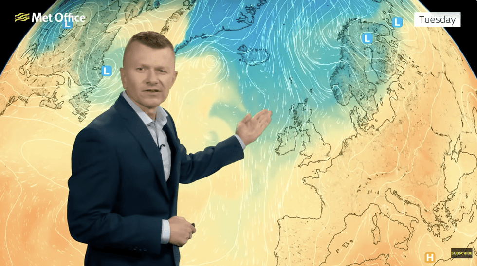
Met Office’s Greg Dewhurst warns of northerly winds
|MET OFFICE
In the UK, El Nino is associated with colder-than-average weather at the end of winter, but it experts think it may be linked to increased summer temperatures.
An El Nino event this year, however, is more likely to impact the weather next summer.
AccuWeather meteorologist Paul Pastelok said: “The sea surface temperatures are quickly changing in the equatorial Pacific, so fast that this El Nino could begin in June.
“Tremendous warming of sub-surface water temperatures across the central and eastern Pacific.”
Meanwhile, Britons are warned to wrap up for a brief chilly hiatus to the warm end to spring.
Temperatures through the middle of the week will dip to single figures across northern counties as the south hovers in the mid-teens.
Met Office meteorologist Greg Dewhurst said: “A change is on the way this week, a colder northerly airflow will set in towards the middle of the week but it shouldn’t last too long before milder air returns. And we will notice a chill in the air as we move through the week.
“There will be a chillier start to Tuesday morning for most of us, with showers most frequent in Scotland, falling as snow over the mountains.
“Temperatures will be widely close to, if not below, average on Wednesday, but slowly recovering towards the end of the week and into the weekend.”