


An undulating jet stream billowing out of America’s big freeze threatens flooding next week as bitter winds turn rain to snow.
Regions at risk of serious flooding after a triple storm assault this month face further heavy and relentless downpours.
Behind the assault is the jet stream, supercharged on its trek across the Atlantic by a historic big freeze gripping the United States.
The start of February will deliver more wet weather as flood warnings escalate, particularly across Scotland, northern and southern England.
TRENDING
Stories
Videos
Your Say
Met Office meteorologist Alex Deakin said: “The jet stream is lively and south-shifted across the Atlantic, and a reason is North America keeps getting cold plunges of air, and cold clashing with warmth fuels the jet stream and helps push it south.
“Over the next few days, the jet stays south shifted and continues to push low-pressure systems our way bringing further spells of rain.
“The rain is the greatest cause for concern, and we are concerned for four main areas, eastern Scotland, Northern Ireland, Wales and Southwest England, because here we are going to see the rainfall totals totting up.”
As the jet stream ploughs low pressure in from the west, high pressure building to the east will put up a chilly defence.
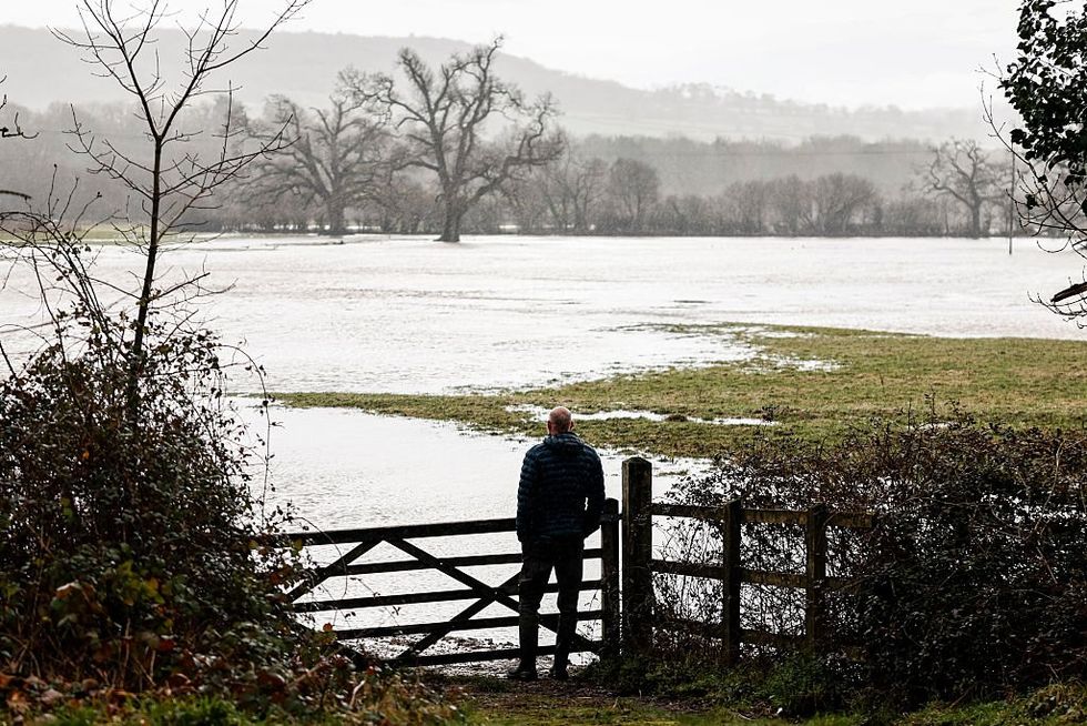
Regions at risk of serious flooding after a triple storm assault this month face further heavy and relentless downpours
|GETTY
The Scandinavian High, which for the past week has driven one half of the battle behind Britain’s fluctuating cold, wet and windy weather, remains on guard.
As mild, moisture-laden winds push into easterly winds, snow will fall at the clash point.
The midlands is most at risk with the heaviest flurries predicted over high ground, although not out of the question is a low-level dusting.
Mr Deakin said: “Low pressure is pushing up against a blocking high area of high pressure and that is why the weather is stuck in this cycle.
LATEST DEVELOPMENTS
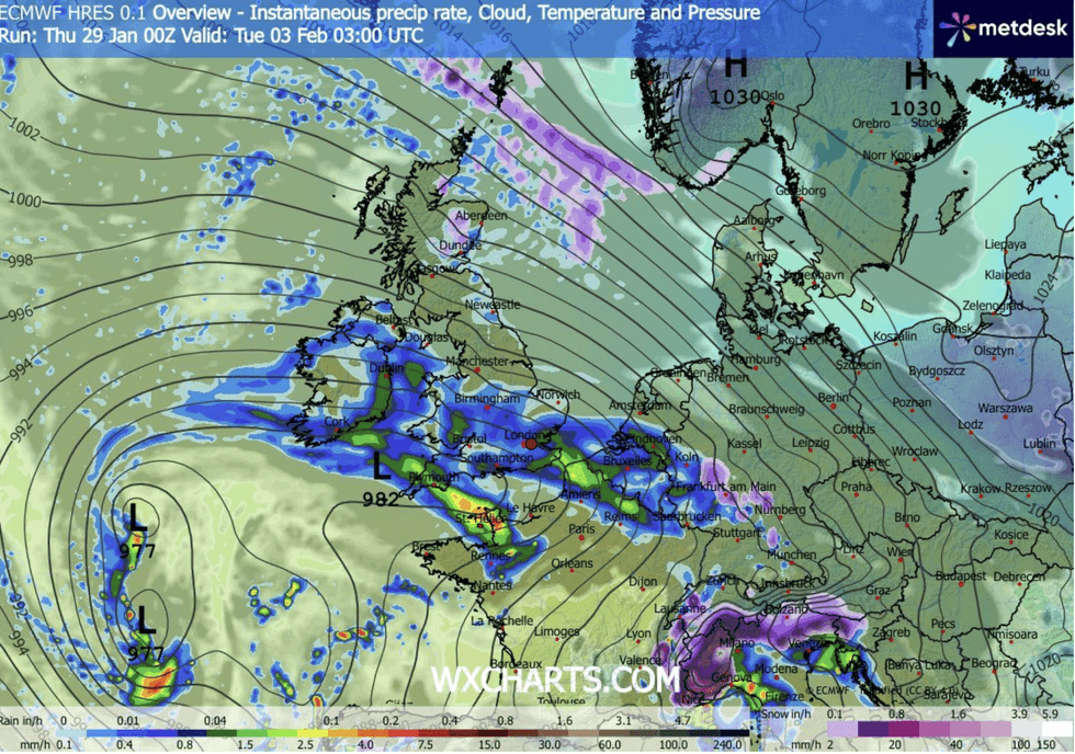
Behind the assault is the jet stream, supercharged on its trek across the Atlantic by a historic big freeze gripping the United States
|WXCHARTS
“There will be some snow, not just over the hills but there could be some to low levels across northern England and Scotland on Friday for a time.
“The pressure pattern through next week is back to where we were with low pressure to the west of the UK and generating south-westerly winds, and , eastern Scotland, Northern Ireland, Wales and Southwest England will bear the brunt of the wettest weather.”
As the battle between west and east rages, long-range forecasters warn rain next month could eventually yield to a bitter cold snap.
Jim Dale, meteorologist for British Weather Services and co-author of ‘Surviving Extreme Weather’, said: “We are still in a battle between the east and the Atlantic, and for the next week, we expect to see more of the same in terms of wet and unsettled weather.
“But there is every chance that during February, it will turn more settled from the west, but we get a colder, easterly influence.
“This could bring more in the way of snow.”
A Met Office warning remains in force across Northern Ireland tonight as the latest band of rain moves through.
“Friday will bring further rain and blustery showers to the west and southwest, with colder conditions further north and slightly milder air in the south," a spokesman said.
“Brighter spells are expected between showers, while Scotland may see additional hill snow.”
Our Standards: The GB News Editorial Charter