


Heavy and ‘relentless’ downpours boosted by an ‘El Nino winter’ threaten one of the wettest periods in US history.
A persistent deluge driven by a spate of storms smashing into California brought San Diego’s fourth rainiest day on record, according to the National Weather Service.
Southern regions face further heavy rain through the rest of the week as officials ramp up a raft of flood alerts.
Thunderstorms will offload almost three-quarters of a foot of rain sparking warnings for dangerous torrents laden with debris from summer wildfires.
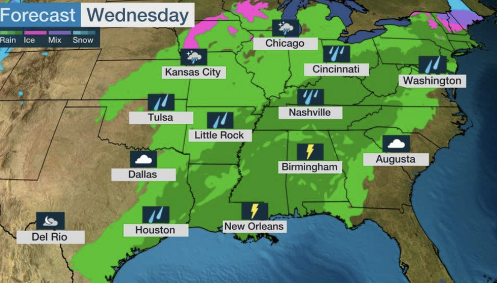
Storms threaten to bring one of the wettest periods in US history
|The Weather Channel
A powerful jet stream ploughing through moisture pulled up from the Gulf of Mexico will drive ‘relentless’ downpours, according to The Weather Channel.
Domenica Davis, meteorologist for The Weather Channel, said: “Rain and flooding, that’s what we’re dealing with for the south, and this is going to be the threat through the rest of the week and that flood threat is going to keep moving to the east, all across the south.
“It moves to the east on Wednesday, and even Thursday, and we are still dealing with more excessive rainfall right into Friday.
“All across the south, we are looking at some pretty big rainfall totals.”
US LATEST: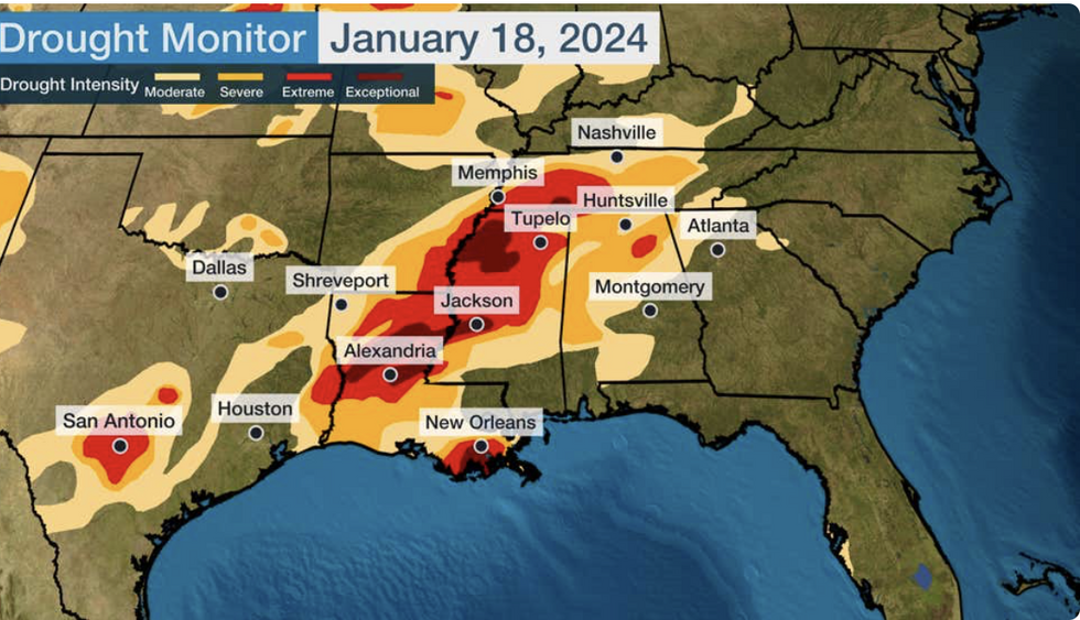
US weather: The rain will hit regions stricken by drought (The Weather Channel)
|The Weather Channel
Worst hit will be Mississippi, eastern Texas and Louisiana, where ground left bone dry from a recent drought will create dangerous runoffs.
Ms Davis said: “This is going to be important to help out the drought, and this is an area that is suffering very dry conditions, so we do need the rain.
“But all of this rain in a short period of time will lead to flooding.”
The barrage of storms is likely to be the result of a strong El Nino, a warming of the eastern Pacific which set in last year.
El Nino can affect weather patterns around the world, including wetter weather in parts of the United States.
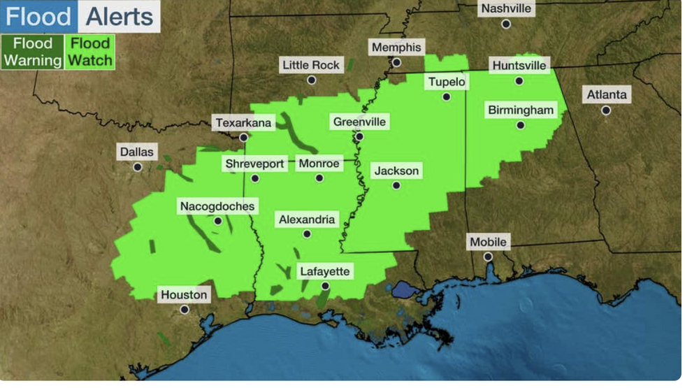
US floods: Weather Channel highlights regions most at risk of flooding
|The Weather Channel
Jim Dale, US weather correspondent and meteorologist for British Weather Services, said: “These storms are, in part, going to be driven by El Nino.
“El Nino is adding to the strength of the storms, and in turn, the very heavy rainfall that is associated with them.
“This is helpful in some ways as these regions have been hit by drought, and it will be a help if they go into another summer of drought.”
The National Weather Service (NOAA) said almost three inches of rain hit San Diego Airport on Monday, making it the fourth rainiest day in records going back 174 years.
Torrential downpours whipped up by storms hammering the west coast overturned cars and triggered evacuation warnings.
NOAA issues flood watch across the south
|NOAA
Southern states have been placed under a NOAA flood-watch advisory, while further north, freezing temperatures threaten snow.
Up to eight inches of rain will fall in the worst-hit regions before the end of the week, forecasters warn.
A NOAA spokesperson said: “Moderate risks of excessive rainfall have been issued for parts of the Deep South and Gulf Coast through Wednesday.
“Heavy rainfall could result in numerous flash floods.
“Freezing rain and snow will create hazardous travel and possible power outages from the Midwest through the southern Great Lakes region and into parts of the Northeast through Wednesday.”
‘Multiple’ low-pressure storm systems ploughing across southern states will collide with moist air creating a deeply unstable atmosphere, they added.
They said: “Multiple waves of low pressure advancing along a slow-moving front across the Lower Mississippi Valley will encounter a resurgence of moisture and instability from the Gulf of Mexico which will aid in the development of heavy showers and thunderstorms today through Thursday.
“Several inches are expected which will increase the threat of flooding across the South.
“The Weather Prediction Centre has issued a Moderate Risk of excessive rainfall across portions of these areas.”