


Britain is warming up for a steam-bath end to winter with temperatures this week rocketing ‘day by day’ to a sultry 65F.
A major shift in wind patterns sweeping the nation with tropical southerlies will push the mercury more than 10C higher than average.
Where the cloud breaks, ‘spring-like’ sunshine promises a national ‘mood switch’ as Britons take a long-awaited breather from the chilly downpours.
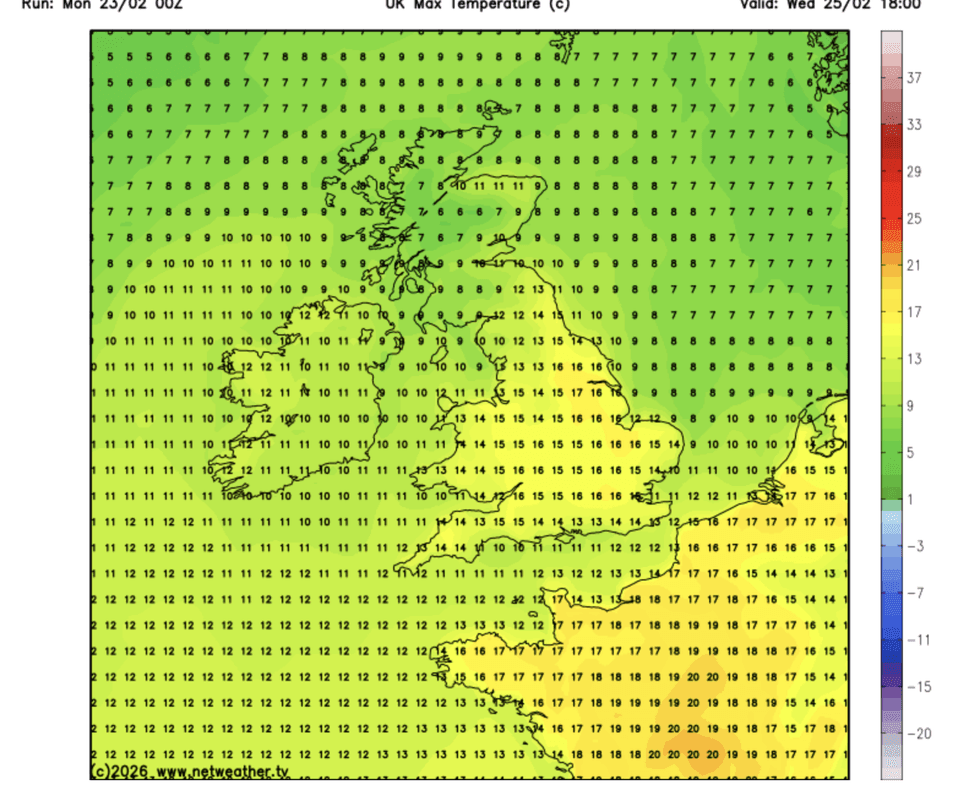
Experts, however, warn to make the most of it with the cold and rain expected to make a comeback at the weekend.Met Office meteorologist Craig Snell said: “Come Tuesday afternoon, we will start to see cloud break up, and it will feel very mild with temperatures easily into double figures, potentially up to 14C of 15C.
“It turns even milder on Wednesday as we drag in very mild air from the south, and we could see highs of 17C or 18C in the southeast.
“But it won’t last as temperatures begin to tumble away again as winds start to come back in from the west, and more spells of wet weather as we end the week.”
Southern counties will see the warmest weather this week although temperatures will lift across the country.
Even overnight, swathes of Britain will go from shivering in the sub-zero to nudging double-figure tropical nights.
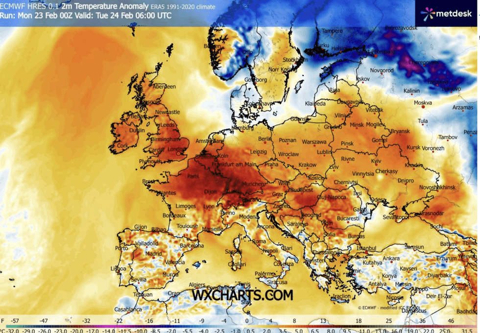
Southern counties will see the warmest weather this week
|WX CHARTS
Mr Snell said: “With winds coming in from the south, some places are not going to sink much lower than 10C or 11C on Monday night.
“The week ahead is set to be quite changeable but also mild for all of us.”
Rising temperatures are the result in part of a shift in weather patterns that have bought weeks of relentless rain.
A ‘blocking’ high pressure to the east, stalling rainy low-pressure systems to the west, will weaken and budge.
LATEST DEVELOPMENTS
Britons will receive a much-needed break from miserable conditions
| NETWEATHER
This will allow in westerly winds, and while there will be more rain, it will move across Britain swiftly instead of hovering for days.
Jim Dale, meteorologist for British Weather Services and co-author of ‘Surviving Extreme Weather’, said: “We are seeing an end to the blocking pattern that has been behind the stubbornly wet weather through the start of this year.
“There will still be rain coming into the west and the northwest, mainly north-western Scotland, but it will be quicker to move through.
“But with the westerlies, it will feel milder.”
Temperatures will peak mid-week, he added, before dropping ahead of the weekend with the return of northerly winds.
He said: “Temperatures will rise day on day, and we could see highs in the mid- or upper teens by the middle of the week.
“Where there are breaks in the cloud, it is going to feel spring-like, and this will trigger a mood switch of the nation after the bad weather so far.
“But it will turn colder again by the weekend.”
Met Office meteorologist Annie Shuttleworth added: “That subtle change from south-westerly to north-westerly winds is looking more likely for the second half of the week into the weekend.”