


Warm winds and storms ferried on a ‘supercharged’ jet stream will hit Britain with a week-long monsoon deluge.
The UK weather is about to undergo yet another overhaul, as temperatures rocket amid warnings of further widespread rain.
While the winter temperature record of 17C is unlikely to fall, thermometers could come close.
Met Office meteorologist Alex Deakin said: “It is pretty mild as we go into the week as milder air is coming in.
TRENDING
Stories
Videos
Your Say
“We are seeing temperatures get widely over double figures and into the teens, and if we get some brightness we could get into the mid-teens in some locations.
“It’s unlikely to threaten the winter high of 17C, but some places may not be far off.”
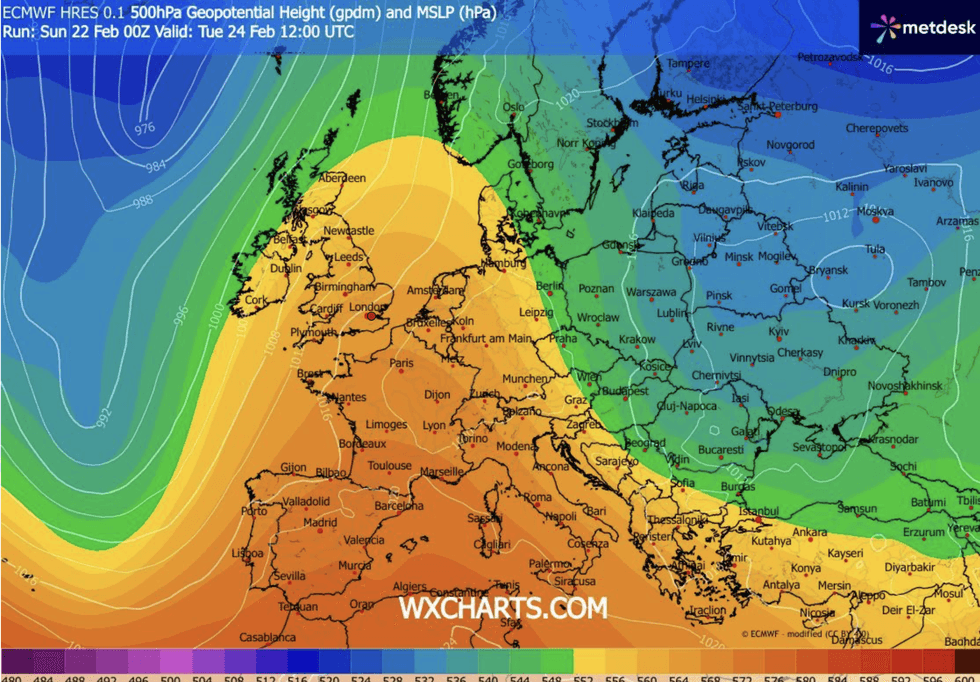
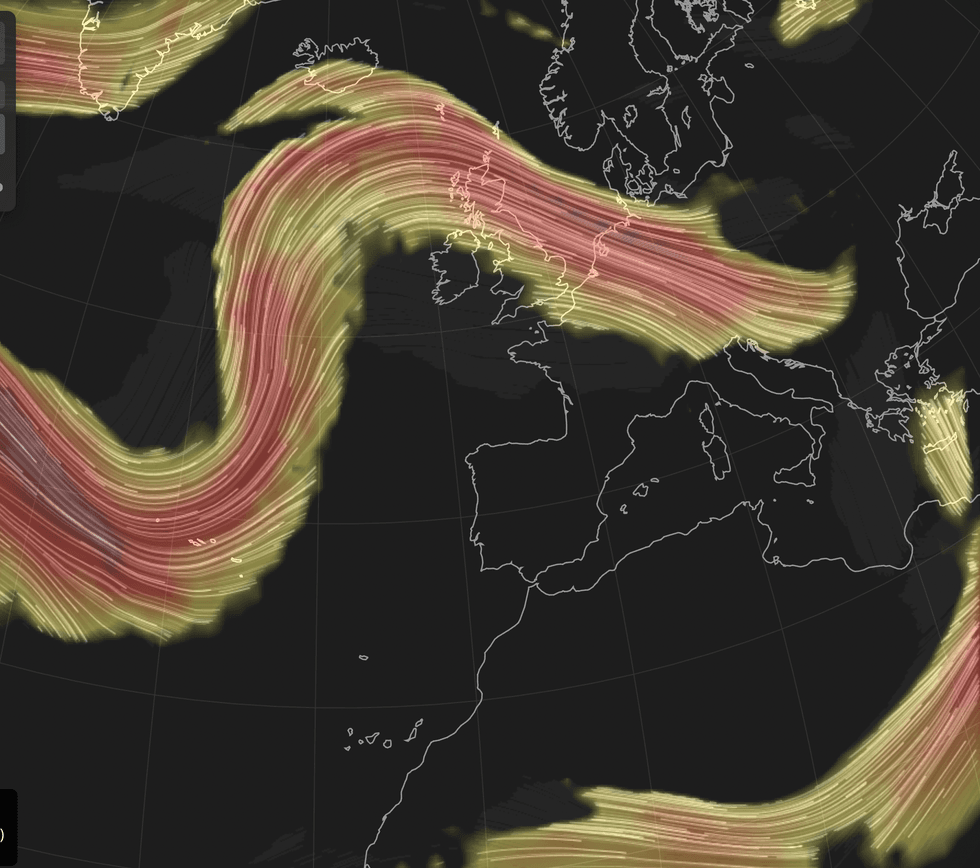
A jolt in the path of a ‘wavy’ jet stream will sweep in mild tropical winds from the southern Atlantic.
However, they will arrive laden with rain-bearing cyclonic weather systems driving further rainfall across Britain.
Despite the rain, temperatures will rocket
|WX CHARTS
While drenched western areas drenched will continue to face the worst of the rain, showers will become more widespread.
Mr Deakin said: “The jet stream remains wavy, and so we will see weather system after weather system coming in from the west or southwest, and that is why it is going to be milder.
“The jet stream has been pushed further north, and it is bringing low pressure systems our way.
“Not much changes through the next few days, even into the middle part of the week, and by then we could have a supercharged jet over the Atlantic.
LATEST DEVELOPMENTS
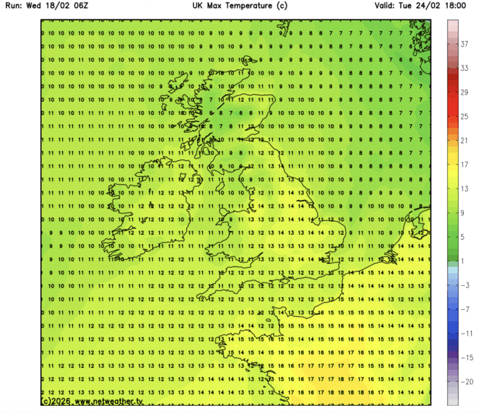
Parts of the country will hit the mid-teens
|NETWEATHER
“There is more rain to come but it is shifting to a different location.”
Despite the rain, temperatures over the coming days will head skywards with swathes of the country hitting the mid-teens.
Highs of 15C-plus are possible in the south by mid-week, with four days on the way of almost spring-like warmth.
Flooding will continue to be an issue across the West Country, where winter rain has triggered a ‘major incident’.
Britain is set for monsoon-like conditions
|NETWEATHER
Jim Dale, meteorologist for British Weather Services and co-author of ‘Surviving Extreme Weather’, said: “The majority of the rain is going to be in the west and the northwest, but there is a change on the way.
“It is going to feel much milder through the week, and day on day, we may see temperatures rise steadily.
“We expect highs in the mid-teens across the south, and further north slightly lower, but warmer than average for the time of year.”
But, one of the wettest winters on record could yet give way to a wet start to spring, he warned, with the Atlantic still in the driving seat.
He said: “We are going into what is traditionally a wet time of the year, despite the rainfall that we have had so far.
“And this means that there is likely to be more rainfall through the start of spring, which will continue to cause issues for parts of the country where flooding is a major issue.”
A Met Office spokesperson added: “Through the early part of the week, another Atlantic weather system will push in from the southwest.
“There is reasonable confidence that cloud and rain will arrive earlier on Monday than suggested by the [weather-forecasting] model.
“This means rain is likely to move into the southwest and Wales during Monday afternoon, spreading further northeast into Tuesday.”