


Storm Benjamin will smash through Britain tonight with a 24-hour thunder, lightning and hail-charged deluge.
Named in the past hour by the French Meteorological service, the storm is one of two to straddle the UK in a near 1,000-mile-wide pincer grab.
Southern regions are in the firing line for ‘big trouble’ as the region braces for 70mph gusts tonight into tomorrow.
Benjamin will usher in a ‘major change’ in the weather from calm to a potentially damaging and widespread storm.
Jim Dale, meteorologist for British Weather Services, said: “There could be big trouble with this storm as parts of the country face heavy downpours, thunder and the risk of hail.
“Storm Benjamin has today been named by the French meteorological service and will signal a major change after the calm start to the season, with much of the country looking at a very unsettled start to the week.”
Weather models show two low-pressure systems hurtling towards the UK, one to the north and one to the south.
It is Benjamin to the south, which has meteorologists sweating, arriving laden with torrential rain, winds and thunder.
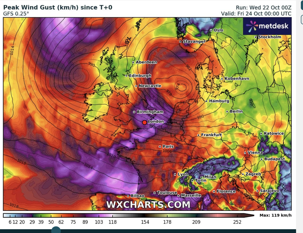
Southern regions are in the firing line for ‘big trouble’ as the region braces for 70mph gusts
|WXCHARTS
Benjamin will be the second named storm this year, although it has taken a title from Meteo France instead of ‘Bram’, the second in the UK’s autumn storm list.
Met Office meteorologist Honor Criswick said: “We will see some very unsettled weather into Thursday, with an area of low pressure pushing into parts of the southwest, and then likely pushing across the south.
“There is some uncertainty around the track of this area of low pressure, but the most likely scenario has southern and eastern areas the most affected with coastal gales and possibly severe gales across eastern coasts and some heavy rain with thundery downpours.”
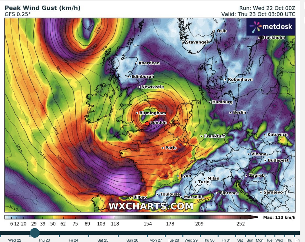
As is typical with violent storms, the cyclonic low may jump the jet stream, crossing from the warm to the cold side in a strengthening move.
LATEST DEVELOPMENTS:
Temperatures are expected to drop as the storm hits Britain
|WXCHARTS
Ms Criswick said: “An area of low pressure is skirting its way across the Atlantic and gets picked up by the jet stream on Wednesday.
“This moves to the left jet exit and the cold side of the jet stream, and when we see this set up, we can see some rapid deepening.
“There is some uncertainty around the track of this area of low pressure, but the most likely scenario has southern and eastern areas the most affected with coastal gales and possibly severe gales across eastern coasts and some heavy rain with thundery downpours.
“There will be quite a lot of rain, and this rain will be heavy at times, and also some fairly strong and gusty winds.”
With heavy rain, thunder and lightning will come hail, forecasters warn, in a prelude to plunging temperatures.
Highs of 16C in parts of the next couple of days will give way to lows below freezing and the risk of snow.
Temperatures ahead of the weekend will start to plunge, bringing wintry showers to high ground.
Mr Dale, meteorologist for British Weather Services and co-author of ‘Surviving Extreme Weather’, said: “There will be a risk of frost and ice, and to the north, over the tops of the mountains, snow.
“Temperatures will fall as northerly winds come in, and for the whole country it is going to feel much colder than it has so far this month.”
Our Standards: The GB News Editorial Charter