


Dashed hopes of a White Christmas are about to make a turnaround as Britain braces for a potential New Year snow blast.
Despite cold, easterly winds pushing temperatures widely to freezing or below today, chances of a winter flurry are down with the mercury at about zero.
Apart from the far southern coast, which may get a fringe dusting tonight, Britain will chalk 2025 up as another Green Christmas.
But Britons hoping to get sledges out before the end of the year may be in luck, with hints of heavy New Year snow.
TRENDING
Stories
Videos
Your Say
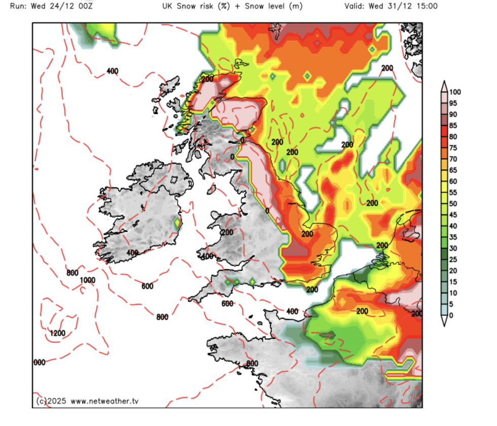
Weather models show swathes of the country facing a wintry deluge towards the end of next week.
Jim Dale, meteorologist for British Weather Services, said: “We have cold air moving over us at the moment, and this is going to stay in place with high pressure over the UK.
“As we move into January, there is going to be a greater chance of snow if we get moisture moving into the cold air.
“There is only a very small chance of seeing any snow on Christmas Day, but this chance increases as we move into the New Year.”
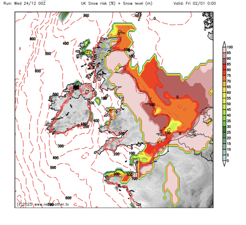
Heavy snow moves in for New Year
|NETWEATHER
Weather models, so far devoid of anything white, have suddenly emerged with a blanket of snow moving in from the east.
They reveal a high chance of heavy snow through the start of January across eastern counties, Scotland and parts of southern England.
Elsewhere, it is a dry, gloomy but bitterly cold picture as freezing winds start to creep in from the east.
While not a typical ‘icy blast’, temperatures through the coming days will widely sink to single figures or below.
LATEST DEVELOPMENTS:
Weather models show swathes of the country facing a wintry deluge towards the end of next week
|NETWEATHER
Met Office meteorologist Alex Deakin said: “It is going to turn quite a lot colder as we go through the Christmas period, and that is particularly across the south due to a brisk easterly wind.
“It will feel colder along North Sea coasts as the easterly picks up, and that is going to get stronger as those high pressures merge.
“It is going to be a mixture of cloud and sunny spells, with high pressure hanging around it won’t take much to provide quite a bit of cloud here and there, but I am quite hopeful that there will be some sunshine around on Christmas Day.”
A bitter wind chill will make it feel colder than -10C in parts of the country in the run-up to 2026.
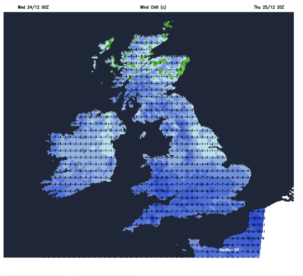
Windchill temperatures down to -13 in the far south coast
|NETWEATHER
This will be across southern coasts, which have the greatest chance of seeing the required one flake of snow for a White Christmas.
Deakin said: “The wind will make it feel close to, if not below, freezing, so there is quite a significant wind chill across the south coast.
“There is the possibility later in the day of seeing some showers across the southwest and with cold air in place, it may provide a bit of snow, making it technically a white Christmas.”
Our Standards: The GB News Editorial Charter