


Scorching sunshine will fizzle in a windy deluge as a barrage of cyclonic storms sweeps the tip of Britain.
Temperatures across Scotland and northern England will fall this week as gusts whip through from the Atlantic.
A north-south split will allow southern regions to cling to the hot weather while the north turns unsettled.
The change will be driven by a shift in the jet stream pulling a low-pressure storm systems across northern Britian.
Met Office meteorologist Alex Deakin said: “The position of the jet stream is sitting over the far north of the UK, and the jet stream steers low-pressure systems, and that is likely to be hanging out to the north of the UK.
“And the closer you are to the low-pressure system, the more likely you are to have outbreaks of rain.
“The most likely pressure pattern is with low pressure somewhere to the north of the UK on each day, and that generates more rain across the northwest of the UK, and with the winds coming in from the west or the southwest.”
It comes after the first heatwave of summer pushed the mercury this weekend to 33.2C in Charlwood, Surrey.
LATEST DEVELOPMENTS: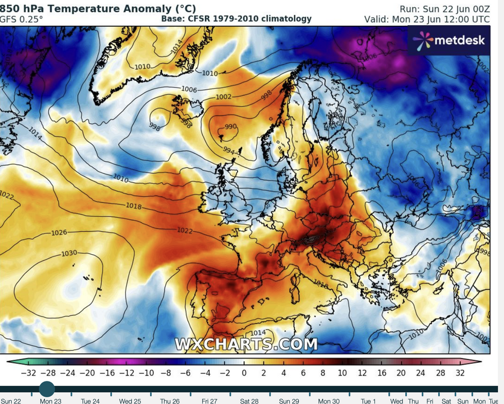
Cold air to sweep over Britain
|WX CHARTS
Sunday was expected to bring the peak of the temperatures, with most of the country feeling fresher this week.
Southern and southeastern regions will stay under the influence of high pressure, keeping the burners going.
However, sun-baked Britons can look forward through the coming days to a ‘more pleasant’ spell of summer sunshine.
Jim Dale, meteorologist for British Weather Services and social commentator, said: “It is going to feel more pleasant for many through the next few days, with the highest temperatures confined to the south and the southeast.
“There will be more of the chance of unsettled weather to the north.”
As the Azores High – a high-pressure dome that has driven the recent hot weather – retreats, rain will creep in from the west, he warned.
He said: “The Azores High has regressed, and with the shift in the jet stream, there will be more in the way of frontal systems coming through from the northwest.
“Here, we will see more of an Atlantic regime, while the rest of the country should stay pleasant through the week.”
As temperatures drop and the UK falls back into the grip of the Atlantic, volatile atmospheric conditions may spark the odd thunderstorm.
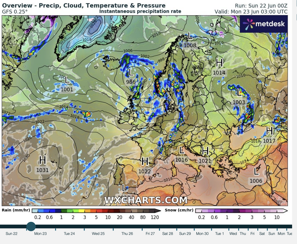
Unsettled low pressure clips the north
|WX CHARTS
Northern regions will be in the firing line to take the brunt of the unsettled U-turn, while the south stays drier.
Jason Nicholls, lead international forecaster for AccuWeather, said: “It will turn cooler across the country from Monday, and there will be the risk of showers as a front comes through.
“Some of these could be thundery and will move southwards through the start of the week.
“The south of the country, however, will stay generally drier and brighter.”
As temperatures drop from the mid-30Cs, experts warn that hotter starts to summer may become the norm.
A Met Office spokesperson said: “What was once a rare meteorological event is now becoming a recurring feature of the UK’s early summer climate.
“While we’ll continue to see natural variability in the conditions we see each year, the rise in 30C-plus days each June is a stark reminder of the changing climate and the need for resilience in the face of rising temperatures.”