


Torrential downpours across swathes of Britain, still reeling from Storm Goretti, threaten flood misery through the end of winter.
Persistent bouts of ‘slow-moving’ Atlantic weather systems will drench western regions ahead of the weekend, with Cornwall, the southwest and Scotland in the firing line.
Up to five inches of rain is forecast through the coming days, pushing rivers and groundwater levels to tipping point.
Met Office meteorologist Alex Deakin said: “There is quite a bit of rain around, and it could be heavy with gusty winds and some snow.
TRENDING
Stories
Videos
Your Say
“Winds are picking up everywhere, and that is going to be a feature of the weather throughout the week.
“There will be some snow mixed in over the hills, and the rain combined with a bit of snow melt and gusty winds providing some large waves means there is the potential for some flooding and some issues in the corner of northeastern Scotland.
“Rainfall totals are building up, and through the full week, the southern Uplands, parts of the east of Northern Ireland, Wales and southwest England could see quite a bit of rain building up over the next few days.”
Britain’s weather is currently dominated by a battle between Atlantic low-pressure storm systems and high pressure to the east.
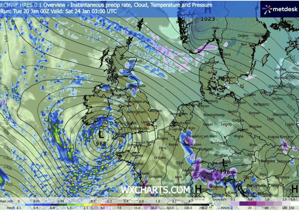
Low pressure hovers off the west coast
|WX CHARTS
As bands of rain push in from the west, the strengthening high will hold them at bay as they shower the western side of the country.
Wales, the West Country and Scotland face a messy week of heavy rain and wind, Deakin warned.
He said: “Low pressure systems are trying to push in, but never manage it, so low pressure is sitting to the southwest, but being blocked by high pressure to the east which is building through the week.
“The cold dense air is preventing the low-pressure systems from making much progress.
LATEST DEVELOPMENTS:
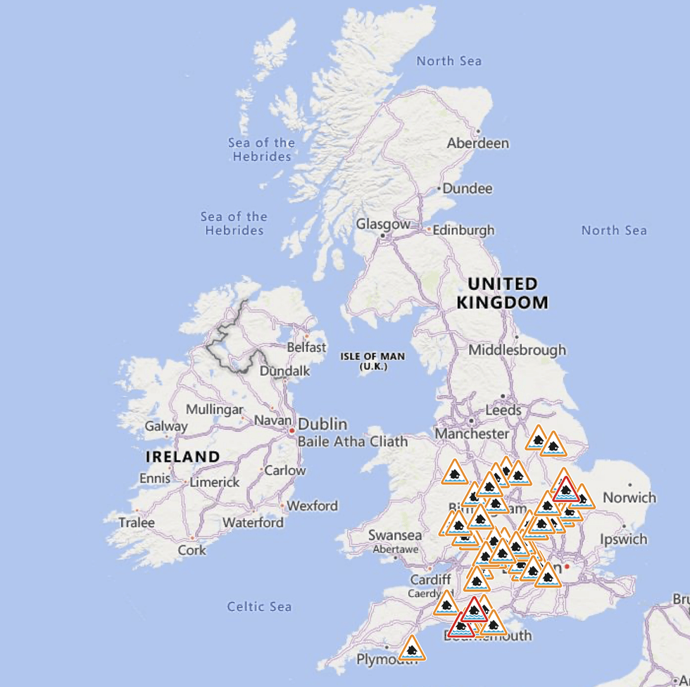
The Environment Agency has put out a raft of warnings
|ENVIRONMENT AGENCY
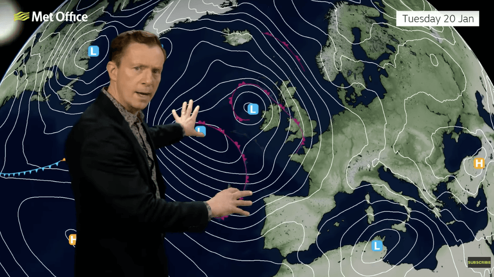
Alex Deakin warns of low pressure to the west
|MET OFFICE
“The winds will get quite brisk along the south coast and continue to feed in across northeast Scotland, and that is an area of concern as the rain builds up here.”
As the threat of disruption builds, the Environment Agency has issued a raft of flood alerts and more serious flood warnings across central and southern Britain.
A spokesman said: “Land, roads and some properties may flood and there may be travel disruption.”
Jim Dale, meteorologist for British Weather Services and co-author of ‘Surviving Extreme Weather’, added: “Western Britain, particularly Wales and the southwest, will be in the firing line for rain and showers through the rest of the week.
“There will be a risk of localised flooding as the rain totals build up ahead of the weekend.
“Britain is still in a battleground between high pressure to the east and the Atlantic lows coming in from the west.”
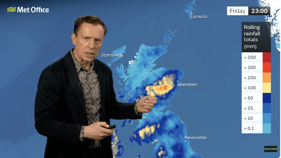
Alex Deakin warns rainfall totals are adding up
|MET OFFICE
As swathes of the country hunker down for wind and rain, the next looming threat is for the return of the cold.
Experts agree that next week could see easterly winds plummet temperatures and revamp the risk of snow.
Met Office deputy chief forecaster Steven Keates said: “While it does look increasingly likely that conditions will turn more widely colder into next week, the timing and extent of this colder air remains uncertain.
“There are variations between the different weather models, and although a few show very low temperature values, this is currently the minority.
“The majority indicate below-average temperatures from the east, but nothing too extreme at the moment.”