


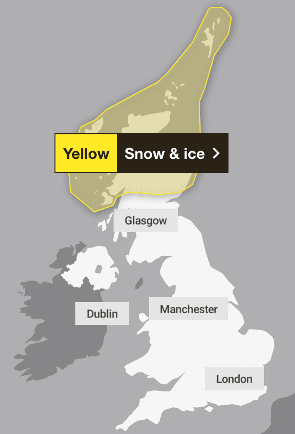
The Met Office has issued yellow weather warnings across Scotland as 20cm of snow looks set to blanket the region as 2026 approaches.
The warning will come into place at 6am on New Year's Day, lasting until 11.59pm, January 2.
"Frequent and heavy snow showers may lead to some travel disruption to begin the year," the Met Office said, adding that there is a high chance of icy conditions.
Warnings to disruption on roads, railway and air travel have been issued, while communities could become cut off and there is a small chance that power cuts will occur and other services, such as mobile phone coverage, may be affected.
TRENDING
Stories
Videos
Your Say
"Showers will turn increasingly to snow through Thursday as a strong, perhaps locally gale force northerly wind sets in," the weather agency said.
"Initially accumulations will mainly affect higher routes, but by evening some accumulations will start to build even to low levels.
"Given the strength of the wind some significant drifting of snow is likely."
Residents have been advised to plan routes and check for delays in what could be "dangerous" driving conditions.
The Met Office has issued yellow weather warnings across Scotland as 20cm of snow is set to blanket the region
|MET OFFICE
LATEST DEVELOPMENTS
"If driving, leave more time to prepare and check your car before setting off; make sure you have essentials packed in your car in the event of any delays (warm clothing, food, water, a blanket, a torch, ice scraper/de-icer, a warning triangle, high visibility vest and an in-car phone charger)," the Met Office added.
Locals were also advised to prepare for power cuts by gathering torches and batteries, a mobile phone power pack and other essential items.
Weather warnings are also likely to change in these conditions, so it has been recommended that those affected stay up to date with weather forecasts in the area.
The areas affected include: Angus, Perth and Kinross, Aberdeen, Aberdeenshire, Moray, Na h-Eileanan Siar, Highland, Orkney Islands, Shetland Islands, Argyll and Bute.
A Met Office spokesman said: "Showers will turn increasingly to snow through Thursday (New Year’s Day) as a strong, perhaps locally gale force northerly wind sets in.
"Initially accumulations will mainly affect higher routes, but by evening some accumulations will start to build even to low levels, with two to five, locally 10cm of lying snow accumulating by Friday morning.
"Above 200 metres some places could see 10-20cm of snow accumulate, and on the highest routes and hills, 30cm or more may build through this period."
A yellow warning is issued depending on how likely or how severe the conditions are.
The Met Office confirmed that this particular warning was for a very low likelihood, but a medium impact.
For example, disruptions to travel and potential impacts to daily routines could be considered as a yellow warning, whereas potential danger to life would be amber or even potentially red, depending on the likelihood.
Our Standards: The GB News Editorial Charter