


A bitter easterly wind sweeping an autumnal chill off the North Sea will put spring’s sultry start on hold.
Despite optimistic forecasts of widespread warm weather, Britons in parts of the country are back in winter coats as the mercury drops to single figures.
The culprit of the abrupt U-turn is the same stubborn high-pressure dome that triggered the freakishly hot start to spring.
But rather than edging south to draw in tropical gusts, it has settled north, opening the gates to the Arctic.
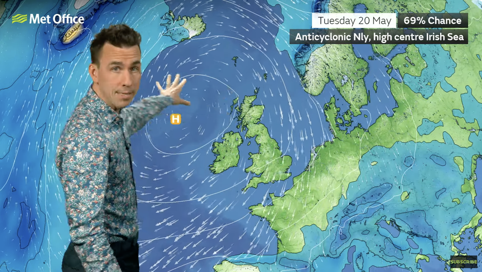
Met Office’s Aidan McGivern describes high pressure to the north
|MET OFFICE
Met Office meteorologist Aidan McGivern said: “High pressure is setting up shop just to the north of the UK, and that high pressure simply stays where it is, and it is not going anywhere for an entire week and perhaps even longer.
“But it doesn’t mean it is going to stay sunny and warm everywhere because we have an easterly wind thanks to that high pressure, and that is pulling in areas of cloud, fret and haar [fog] into eastern parts of the UK, and that easterly wind will bring a difference in temperatures.
“Very little changes day-to-day, and we will see cloudy conditions to start off with, but by the afternoon it is the North-Sea coast where the cloud will persist.”
A nationwide split through the weekend will bring the coolest temperatures to the east coast, he said.
But even inland, chilly Britons can hope only for highs in the low-20Cs – a far cry from the early May near-30C.
Northerly high pressure will hold fast into the middle of next week, keeping Britain trapped in a chilly gloom.
McGivern said: “Into the weekend, it is more of the same with perhaps a lot of cloud to begin with temperatures limited towards the east with 22C or 23C where we have sunnier skies towards the west of the UK.
LATEST DEVELOPMENTS:
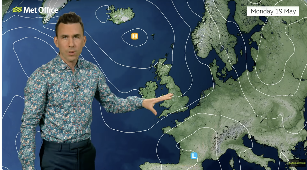
With the high now stuck to the closer to the Arctic circle, northerly winds are putting a hold on the heat
|MET OFFICE
“Monday into Tuesday and Wednesday it is very similar, and when you look at other computer models, they are all saying the same sort of thing.
“They all keep high pressure near the UK for Tuesday, and in fact into Wednesday, and up until the middle of next week, that situation where we have high pressure to the north is almost exclusively the one that is being predicted by computer models.”
Britain’s chilly blip comes after hopes of a near return to the hot weather that kicked off the month.
High pressure further south of the UK during early May rocketed temperatures in warm winds in from the Continent.
With the high now stuck to the closer to the Arctic circle, northerly winds are putting a hold on the heat.
But it is not a complete horror story, with western and southern regions this weekend likely to hit the low 20Cs.
Met Office meteorologist Honor Criswck said: “There is more of a northeasterly breeze along the east coast, and that is going to make things feel a little chillier here.
“But for many, across the west it is going to remain feeling warm.”
Despite cooler temperatures, the obstinate pressure set up bringing more dry weather will push parts of the UK closer to drought.
After one of the driest starts to spring on record, rain-starved regions will continue to parch.
Jim Dale, meteorologist for British Weather Services and co-author of ‘Surviving Extreme Weather’, said: “The dry weather in parts of the country which are now facing drought will continue to be an issue with no significant rain on the cards for the next week or so.
“This could become a problem as we go into summer, as it is this time of year that we rely on rainfall to fill the reserves.
“There is also a risk with the very dry ground that as temperatures rise, we will have ideal conditions for the spread of wildfires.”