


Summer will be held at bay by raging jet stream winds pumping Britain with storms supercharged with hail, thunder and cold winds.
Temperatures will nosedive through the next 24 hours with tomorrow likely to be the coldest day for weeks.
Heavy rain will plough in from the Atlantic as a churning storm off Northern Ireland is spun into a frenzy by the jet stream.
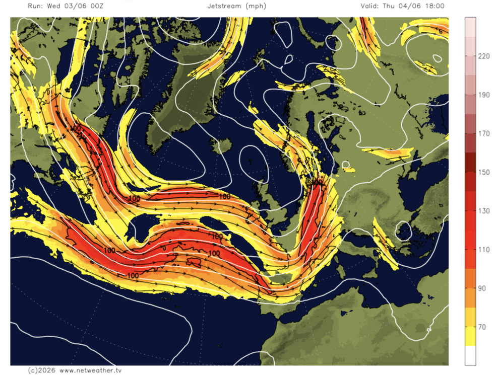
The rapid channel of air high in the atmosphere that is a primary steer for the weather has sprung into an unusually potent beast.
Met Office meteorologist Aidan McGivern said: “The next system will come in hot on the heels of the last one, with a stronger-than-average and more south-shifted than normal jet stream sending in low-pressure systems.
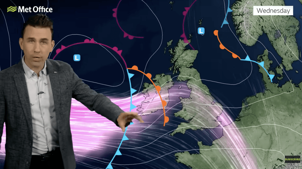
“Showers will rotate around an area of low pressure that is centred just off Northern Ireland and the west of Scotland, and there are longer spells of rain rotating around it.
“Thursday is an especially showery day with low pressure centred off Scotland, and quite a number of showers will move in.”
Heavy downpours will first hit northwestern regions before sweeping south by the end of the week.
Cold winds and explosive storms threaten to end the first week of summer with an ‘unpleasant dog’s dinner’.
Mr McGivern said: “Lots of showers will push into the south and southwest, so it is a right dog’s dinner by Thursday, and with a strong breeze, it is an unpleasant start.
“Showers will be lively with gusty winds, hail and thunder, and temperatures will be a degree or so down, with the coolest day of the week expected to be Friday.”
The grim start to the season follows a historic end to spring with roasted the UK in the hottest May temperatures ever recorded.
LATEST DEVELOPMENTS
Showers will be lively with gusty winds
|MET OFFICE
Daytime highs of 35C-plus simmered into tropical nights with thermometers hovering above a sticky 20C.
Met Office records reveal an average maximum May temperature of 21.6C in London with similar values across the country.
High pressure, which formed a sweltering heat dome over Britain, has receded to allow stormy low pressure to dominate.
A Met Office spokesperson said: “The prolonged warmth, which saw temperatures exceed 30C on multiple days, has now given way to a more typical early summer pattern driven by Atlantic weather systems.
“Low pressure will be the dominant feature through the week, tracking eastwards on a relatively southerly jet stream.
“This will bring a mix of rain, showers, gusty winds and cooler temperatures, replacing the settled and hot conditions seen recently.”
Heavy rain threatens flash floods in parts of the country as powerful thunderstorms erupt across Britain.
Jim Dale, meteorologist for British Weather Services and co-author of ‘Surviving Extreme Weather’, said: “Thunderstorms have the potential this week to be severe in parts, with the risk of flash floods where there are heavy downpours.
“It is going to feel cooler in the breeze.”