


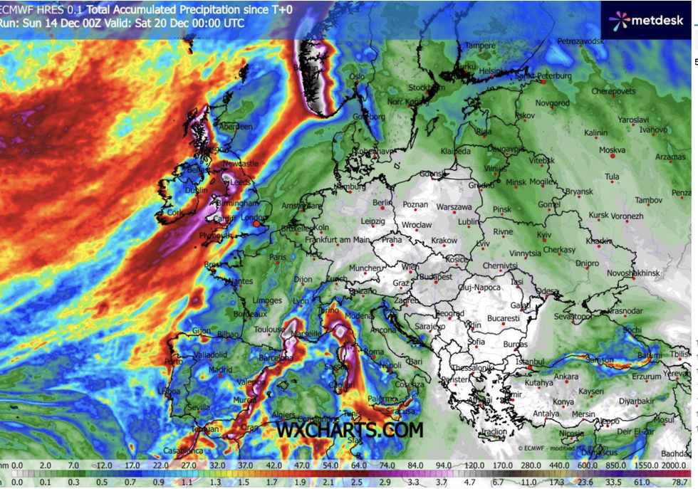
Almost two month’s rain threatens a Christmas flood disaster across half of the country while the other half parches.
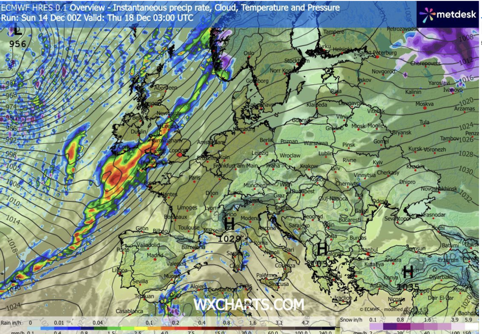
Storms ploughing in from the Atlantic threaten to dump eight inches of rain as sirens sound across western regions.
Eastern counties, however, will dodge all but the odd drizzle with water levels still low after the long, dry summer.
A raft of government warnings is in force through the start of the week as relentless bands of rain sweep Wales, Cumbria, Scotland and northwest England.
TRENDING
Stories
Videos
Your Say
Met Office meteorologist Greg Dewhurst said: “Rain driving in from the Atlantic for the next few days will make over 200mm of rain possible in places.
“Disruption is likely and flooding is possible in places with tricky travel conditions, although central parts of England and Wales is a largely dry picture.
“Through Monday, it is another wet day with rainfall totals building and rainfall warnings remaining, and the winds still coming in from the south so temperatures will be around 11C or 12C.
“The rain slowly pulls away during the evening, but it stays unsettled with further rain and strong winds at times.”
Bands of rain sweep into the west
|WXCHARTS
Southerly gusts will keep temperatures higher than average for the time of year, although cloud cover will dampen the glow, he said.
Atlantic winds will push a series of stormy low-pressure systems into Britain through the next 48 hours, with western regions bearing the brunt.
Met Office meteorologist Annie Shuttleworth said: “There is another system on the way through on Monday, and it will bring a spell of wet and windy weather particularly to northwestern areas, but most areas will see an unsettled day.
“Another area of low pressure pushes up to the northwest of the UK, and this is potentially an active one bringing some strong winds and wet weather on Monday.”
LATEST DEVELOPMENTS
Southerly gusts will keep temperatures higher than average for the time of year
|WXCHARTS
A brief respite will give way to yet another mid-week low with coastal gales whipping up by the weekend.
Shuttleworth said: “On Wednesday, we will see the return of low pressure, and by Friday low pressure systems to the north are bringing in westerly winds, so it is likely to stay pretty unsettled through the week, but it will remain fairly mild.”
Torrential downpours threaten disruption in the run up to Christmas with festive floods more likely than snow.
As parts of the country brace for inches of heavy rainfall, elsewhere lighter persistent rain poses a similar flood risk.
Jim Dale, meteorologist for British Weather Services and co-author of ‘Surviving Extreme Weather’, said: “Rainfall accumulations are going to become a significant issue through mid-month, and not just where we see that 200mm, but where rainfall is persistent but lighter, this will bring the risk of flooding over the next week or so.
“Another system comes through on Wednesday, again hitting the west of the country, and winds will pick up around the coasts.
“The rain is going to be an issue to the west of the country, mainly, but towards the east they are getting little to no rain and are still technically in a drought situation after the dry summer.”