


Multiple Met Office rain warnings are set to strike Britain in just a matter of hours, with those in the worst-affected areas told to expect flooding.
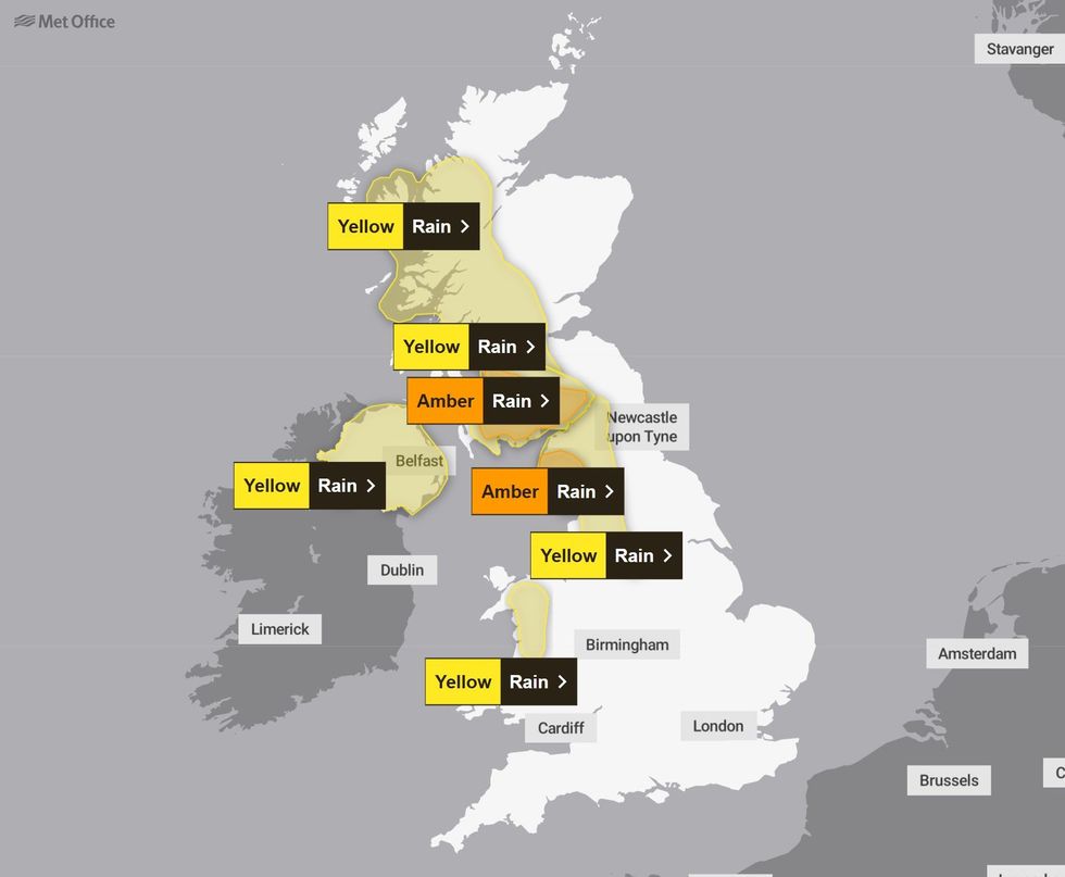
Two amber alerts and five yellow alerts will strike across the west coast of the UK in a continuous 300-mile line from just outside Sheffield to Ullapool.
The first of the warnings began over west and southwest Scotland at midday today, with the last of the alerts concluding around 6pm on Monday in northwest England.
In total, the warning area covers northwest England, west and southwest Scotland, Northern Ireland and parts of Wales.
According to the forecaster, heavy and persistent rain has already started becoming established over west Scotland, Northern Ireland and northwest England.
It predicts gusts of 60 to 70mph are possible along coastal areas in the west of Scotland.
The amber warnings, which have been issued for parts of Dumfries & Galloway and Cumbria will see particularly notable rain accumulations.
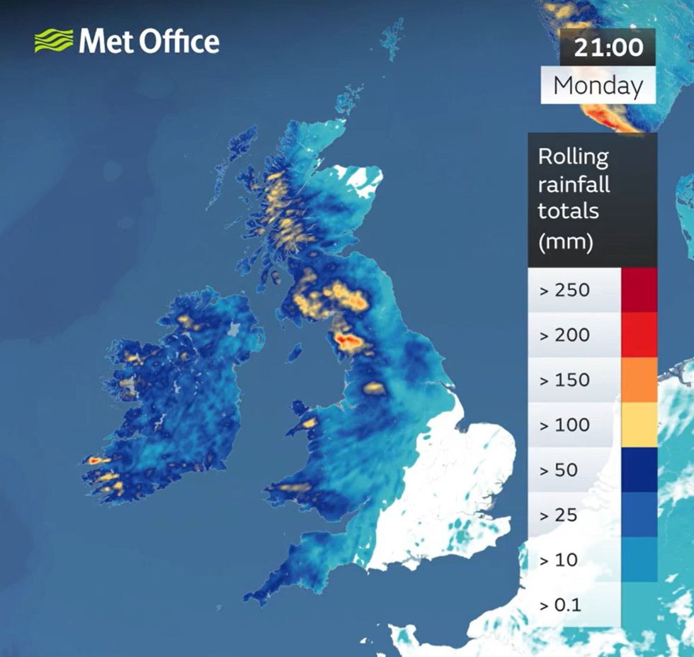
Some areas could see more than 200mm of rain – approximately two months’ worth – over 48 hours.
Met Office rain warnings will come into force across Britain in just hours
|MET OFFICE
More widely, totals of 40-70mm are likely, with over 100mm on higher ground of western Britain and up to 50mm possible over higher ground in Northern Ireland, the Met Office said.
Met Office Chief Meteorologist, Rebekah Hicks said: “The northwest of the UK is set for a very wet weekend, with persistent and heavy rain accompanied by strong winds.
“Rain will move in through Saturday morning and become established and slow-moving across central and northwest parts of the UK through the weekend.
“We have issued numerous severe weather warnings for rain, and it is possible that these could be updated so I’d advise people to keep an eye on the forecast and for Met Office weather warnings.”
LATEST DEVELOPMENTS:
Heavy and persistent rain is expected across the north and west over the coming days
|MET OFFICE
Jonathan Day, Flood Duty Manager at the Environment Agency, said: “Significant surface water flooding impacts are possible in parts of the North of England on Saturday, Sunday and Monday.
“There are also possible significant river flooding impacts in parts of the North of England on Sunday and Monday, with minor flooding impacts possible more widely across northern England over the weekend.
“Environment Agency teams are out on the ground, taking action to reduce the impact of flooding and support those communities affected.
“We urge people not to drive though flood water – it is often deeper than it looks and just 30cm of flowing water is enough to float your car.
“People should search ‘check my flood risk’, get free flood warnings, and keep up to date with the latest situation at @EnvAgency on X.”
Elsewhere, the southern half of the UK will be dry and bright, with light winds.
But where there are cloudless skies in the south of England, there could be patches of frost, mist and fog to start the day on Saturday.
Sunday is forecast to remain dry for many through the day, but there may be a band of rain slowly moving southeastward through Sunday night and Monday.
Looking further ahead, the Met Office says rain will cling on across the far southeast for a time on Tuesday.
Further wet and windy weather will move in on Wednesday as another area of low pressure approaches from the Atlantic.
Heavy rain will lead to flooding and disruption over the coming days ⚠️
— Met Office (@metoffice) December 13, 2025
All the latest warning info can be found here https://t.co/QwDLMfRBfs pic.twitter.com/haHIUmFxTe
In a long-range forecast from December 18 to December 27, the Met Office said: “Unsettled and generally mild at first with showers or longer spells of rain affecting the UK at times.
“Some heavy rain is possible anywhere, but it is likely to be heaviest and most persistent in the west and northwest, with sheltered parts of the east and southeast typically drier.
“Any snow will probably be confined to high ground in the north. Strong winds are possible at times with a risk of gales, especially along coasts and over higher ground.
“During the period, conditions are likely to become more settled, with rainfall amounts decreasing and drier weather becoming more prevalent.
“This may mean an increasing amount of overnight fog and frost, with temperatures overall dropping to around average, but it will be chilly if or where any fog persists.”
Our Standards: The GB News Editorial Charter