


Rain-swept Britain will stay in the washing machine for the next fortnight thanks to a ‘wall of ice’ over Greenland.
As experts promise an Easter respite from the foul weather, the forecast beyond the first week of April is back to wet and windy.
The culprit is a huge mass of cold air over Greenland dubbed a ‘wall of ice’, wedged in place by a powerful ‘blocking’ high pressure system.
Pushing the jet stream further south, it will thrust cold and warm together over the Atlantic to spawn a barrage of stormy weather systems.
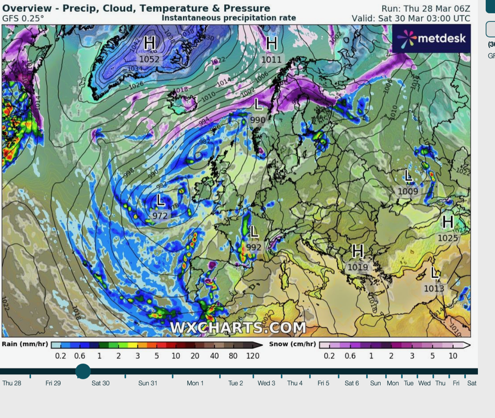
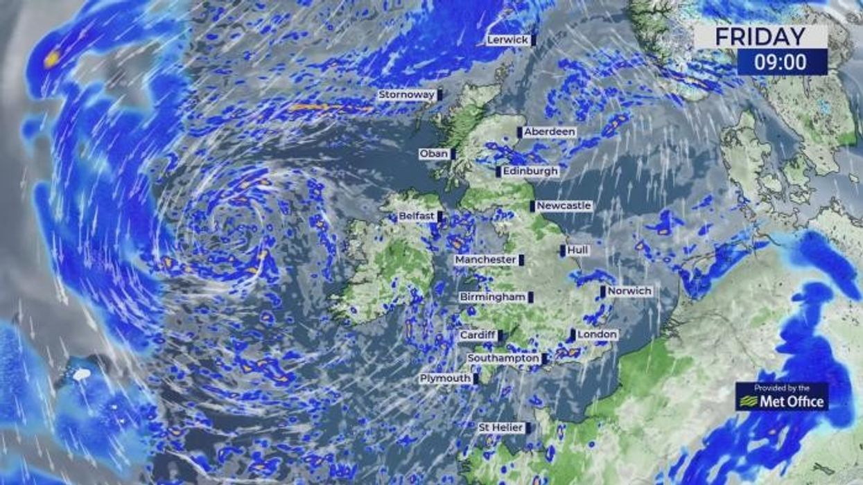
Isolated wintry showers will be a risk through the Easter weekend as bands of precipitation sweep into the UK
|WXCharts
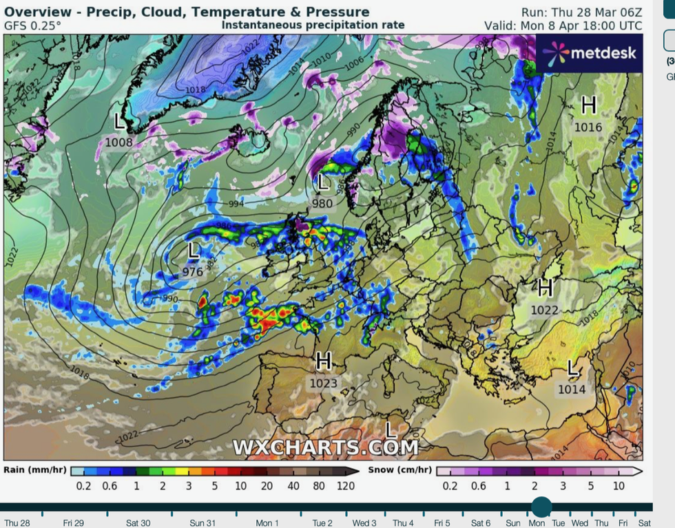
The Greenland high is expected to stay in place for at least the next 10 days to a fortnight, meaning little change in the unsettled weather.
Jim Dale, meteorologist for British Weather Services and social commentator, said: “Nothing is going to change until we lose the Greenland high, and there is nothing to suggest this is going to move for at least 10 days or longer.
“The unsettled weather is being pushed towards the UK the Continent, by a ‘wall of ice’ over Greenland, in effect, a huge mass of cold air that is shunting the jet stream to the south and allowing low-pressure systems to bring in these wet and windy conditions.
“In addition, the cold air to the north is meeting warmer Atlantic air from the sub-tropics, and this is creating the ideal conditions for lows to form which are then swept towards the UK by the jet stream.
“Although we would love to see a change in the weather during the start of April, this high-pressure system is worryingly present through the start of the month, which means more of the same.”
Lower-than-average overnight temperatures driven by Polar air smothering parts of the UK also threatens snow.
LATEST DEVELOPMENTS:
The unsettled theme will return next week as low pressure resumes its soggy onslaught
|WXCharts
Isolated wintry showers will be a risk through the Easter weekend as bands of precipitation sweep into the UK.
Parts of the country were left under a wintry blanked this week as snow fell across Cumbria, Scotland, Wales and even to the south of England.
The late taste of winter shows no signs of disappearing just yet, with cold weather on the cards after Easter.
James Madden, forecaster for Exacta Weather, said: “There is high confidence for further cold weather next week and during the first half of April.
“This is a gentle reminder that winter weather is still possible this late in the year, and over the coming weeks this risk will continue, perhaps even to lower levels than we have seen so far.”
Soaked Britons have been offered a glimmer of hope for Easter with rain to ease over the weekend.
However, the unsettled theme will return next week as low pressure resumes its soggy onslaught.
Met Office deputy chief meteorologist Dan Harris said: “The weather is expected to gradually improve following the widely unsettled spell of the past few days, with a fairly typical mix of spring-like weather across the UK.
“Tuesday looks mostly settled, between one area of low pressure responsible for Monday’s rain in the south or southeast, clearing to the east, and another low arriving from the southwest later.
“It will herald a further spell through early April of unsettled weather focussed particularly across southern areas; best chance of any more settled conditions, and probably colder conditions, will be across the north of the UK.”