


A duo of battling "giants" goaded by 200mph jet stream winds will plunge Britain into a week of storm hell.
In the wake of Storm Chandra, swathes of the country face torrential rain, snow and severe gales until the end of January.
A powerful jet stream fired up by a historic winter storm hitting the United States will drive cyclonic pressure systems into the UK west coast.
Britons are warned to prepare for flooding, travel disruption and power outages as brutal weather digs in.
TRENDING
Stories
Videos
Your Say
A raging war between the Atlantic and a huge anticyclonic high-pressure system over Scandinavia will keep Britain in the spin cycle.
Jim Dale, meteorologist for British Weather Services, said: “Storm Chandra on Tuesday will bring some very strong winds and heavy rain from the Atlantic, and this is going to be the theme for the next week at least.
“The continuous bands of rain coming in from the west are the stalling over Britain as two opposing giants battle each other, and on Tuesday that will bring very strong winds and stormy conditions.
“The unsettled weather will continue, with the Atlantic winning out rather than the cold, so for the next week at least, there is no signs of a real cold snap, but instead periods of wet and windy weather.”
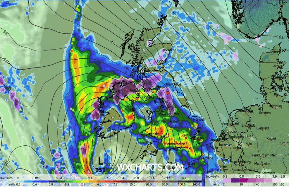
Storm Chandra is wreaking havoc across Britain
|WXCHARTS
Britain’s weather is in part coming under fire from the winter mega freeze gripping the United States.
Cold and mild air colliding over the country is fulling the jet stream as it conveyor belts low-pressure cells towards the UK.
The pattern is set to continue into the end of the month with the Met Office ramping warnings for wind and rain.
Met Office meteorologist Tom Morgan said: “The rest of January is set to stay very unsettled and wet with various areas of low pressure bringing some windy weather, too.
LATEST DEVELOPMENTS
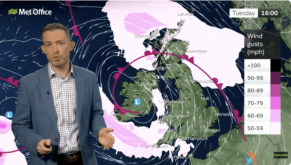
Tom Moran warns of incoming stormy weather
|MET OFFICE
“We have a very strong jet stream, and it is the jet stream that determines our weather, and through the next few days a very powerful jet stream will bring areas of low pressure towards the UK, and they are running up against a block of high pressure over Scandinavia bringing a continuation of the wet and windy theme.”
A deep low due to hit early today will bring travel disruption and the risk of flooding, he warned.
He said: “Tuesday is going to be a very unsettled day, and there is going to be a lot of surface water on the roads and very heavy rain.
“Further north, there will be a lot of heavy rain and hills snow, and there will be some strong winds particular towards the west.”
Jet stream core winds could hit 200mph through the week, the usual speed being around 130mph.
While the main threat will be from wind and rain, the higher ground of Scotland and northern England may catch a dusting of snow.
Met Office meteorologist Annie Shuttleworth said: “It is actually the rain that we are going to focus on, because we are expecting further heavy rain, and on Tuesday, it is places that are already saturated that are going to see more heavy rainfall.
“We are likely to see some quite strong winds with this area of low pressure, and so we don’t need the gusts to be that high for further impact.
“It is turning colder, and we will see an increased likelihood of snow, but it looks like it is going to be another pretty wet and windy week.”